Two pdf files, Beckenham and Beckenham Place one for the Park and one for the whole of Beckenham and some connected districts have information but may not have the latest edits.
Pat Manning has kindly permitted us to add her book THE CATORS OF BECKENHAM AND WOODBASTWICK to this website for interesting information on the Cators' family history in pdf format.
A Shortlands House History in pdf is also available via this link, compiled by Keith Baldwin, it adds some detail to the land transfers of the 18th and 19th centuries. This history will also be edited as the material is updated.Beckenham Place Park was opened as a public park in 1929 after being purchased from the Cator Estate by the London County Council in 1927. It was purchased to provide open space for people to enjoy in what was an increasingly urbanized area. It is the remains of a large country estate accumulated by John Cator (the younger) between the 1750’s and his death in 1806.
For a long time the park's original creation was dated to 1773 when John Cator purchased the land and rights of Beckenham Manor from Frederick St. John, 3rd Viscount St. John, 2nd Viscount Bolingbroke. However the story begins significantly earlier in the Manor of Foxgrove rather than Beckenham and is more complex than hitherto believed or explained. We have discovered or rediscovered material which both pushes back the beginnings of the park to 1760 and delays the date at which the whole park was established to 1785 or later. Perhaps the name “Beckenham Place” can be dated to 1773 or thereabouts, but the house was referred to as Stumpshill or Stump's Hill in letters sent by John Cator. When Cator bought Wricklemarsh at Blackheath in 1783 he was referred to as John Cator of Stump's Hill. For these reasons we have explored in detail earlier events that relate to the evolution of the park.
Several
local historians have mentioned Beckenham Place Park and a few have
written more about it. But it is now time to clarify, expand and
correct some
details. Also, to dispel some myths and look at some details which are
still vague or needing confirmation. This work takes the accounts of
Beckenham’s history written from the 17th century and reviews the
references to information relating to the Park and the area in which it
was created. Then we add to and amend the information from these
accounts with more recently discovered, rediscovered and re-assessed
information from various archives. The companion page about Beckenham
generally may be of interest to you. This park history also formed the foundation of our "A History of Beckenham".
The previous writers include:
John and Thomas Philipott 1659 History of Kent “Villare Cantianum”,
Edward Hasted 1778 first edition Topography and History of Kent and second edition in 1797/99,
Daniel Lysons 1796 Environs of London,
W.H.Ireland 1828 A New and Complete History of Kent,
Robert Borrowmans 1910 Beckenham Past and Present,
Rob Copeland 1967 Manors of Beckenham,
Nancy Tonkin and Eric Inman’s Beckenham circa 1990,
Eric Inman’s 1995 series of articles on the History of Beckenham Place Park written for the Friends of Beckenham Place Park,
Pat Manning 2000 Cators of Beckenham and Woodbastwick,
Pat Manning passed a copy of an account written by a later John Cator (1862-1944) written shortly before his death, which gives family insight but even here I would suggest that some details are legend rather than fact and even the Cators were not aware of some information.
Some if not all of these writers drew, as we do, on the works of their predecessors and contemporaries. Hasted refers to Philipott, Lysons to Hasted, etc. Sometimes fiction is written as fact such as we believe some assumptions referred to later in this account. But I also indulge in a few speculative scenarios based on available evidence. In 1830 W.H.Ireland wrote another complete history of Kent but draws mainly on Hasted with some timely updates i.e. describing the then owner of Beckenham Place and the park being embellished with infinite taste by its affluent owner (John Barwell Cator, the nephew of John Cator). Ireland may have hinted at answers to some outstanding questions regarding Cator’s acquisition of the mansion house site. I acknowledge the open source nature of some information which I would only have been aware of via the internet, catalogue searches, e-books, websites etc. at the same time asking researchers to be wary of some errors that still exist in several sources in print and online. With that in mind this work is intended to be open source and freely available subject to copyright restrictions of third party material.
Some information came to us from anecdotal and written information from visitors to the park or members of the Friends of Beckenham Place Park. Margaret and Malvin Mitchell have from time to time conducted various researches on different aspects of the park during their time in administering the Friends of Beckenham Place Park and the Friends Visitor Centre in the park. We have been ‘enlightened’ in some areas by the knowledge and opinions of others such as Ken White of Lewisham Local History Society. Sadly some of these people are no longer with us to proof read this account.
Some material in Bromley Historic Collections and county archives was at some time derived from other archives such as the British Library. Our recent rediscovery of some of this material has contributed toward our reassessment of the evolution of the park. Although some of the above writers knew of this material they may not have been so focussed on the park in order to analyse the content. The archive catalogues searched include: The British Library, The National Archive, National Library of Scotland (maps), Bromley Historic Collections, Surrey Archive, West Sussex Archive, etc. Some archives do not have an online catalogue i.e. Lewisham, Lincolnshire, etc. where we know some records are stored. Probably the Cator family have records that could enlighten us further.
The Internet has also revealed sources as books become available in e-book form and various archives become electronically indexed. Google books and other versions include: Philipott’s, Hasted’s, Lyson’s, and Ireland’s histories, Collinson’s letters, Memorial of Humphrey Marshall and John Bartram, Life of Dr. Johnson, Hester Thrale, Lady D’Arblay, Memoirs of George IV and Memoirs of William IV, etc.
We
aim to represent as accurately as possible the evolution of what is now
a public park in the ownership of a local authority (and acknowledge
that the local authority is or should be owned by its constituents and
the wider populace). Other information which can be authenticated is
always welcome and we would aim to prove the accuracy of our account.
We are still unravelling the various accounts which appear to have
inconsistencies.
Pat Manning of Beckenham Local History Society still publishes local
history books: 'The Cators of Beckenham and Woodbastwick' (2002) and
other publications. Also Niel Rhind's Blackheath Village and Environs
Eric Inman (in memorium) produced a series of articles for the newsletter of the Friends of Beckenham Place Park during the 1990's. We regarded his account as definitive for several years and his work is drawn upon here with updated information. He had recorded that Cator arrived at Stumps Hill prior to 1773 based on evidence at his disposal.
More recently I acknowledge Hortus Colinsonianus by Peter Collinson which emerged on the internet from the Linnaean Society and Bodlean Library.
Also the material sourced by Mother Mary Baptist formerly Bessie Taylor who wrote a thesis “Bromley, Beckenham and Penge from 1750” in 1967.
Although we challenge some details in these works we recommend for reading any or all of them for background information and interesting detail. Some are now out of print and only available from libraries and archives. Philipott’s, Hasted's, Lyson’s and Ireland’s works are now published on-line and several archives can be searched. Borrowman’s book is in Bromley Libraries and as he was church warden at St. Georges he draws upon interesting items from Parish Council records. Items from the Rob Copeland collection of material have also provided clues and material from Bromley Local Studies library. Resources have been researched at Bromley Historic Collections, Kent Archive Maidstone, The British Library, Portcullis House Parliament Archive Catalogue, the National Library of Scotland map archive and elsewhere.
Dated estate plans in the British Library and Bromley Historic Collections have enabled the analysis of landholdings by landlords at specific dates. This has allowed for discovering detail which is not in the earlier written records.
Other
writers who drew on Philipott’s and Hasted’s work are Daniel Lysons
(1796) and H.W.Ireland (1830). There are other publications drawing on
these works and some contain what appear to be errors and omissions. A
book about Bromley by E.L.S.Horsburgh challenges Philipott and hence
also Hasted and Lysons regarding Simpsons in Bromley so unless facts
are substantiated a pinch of salt should perhaps be taken with all
previous accounts.
Lyson’s
work was published after Hasted’s first edition but prompted a 2nd Hasted edition produced after
Lyson’s. Other works have become buried in the archives such as the Dr.
Gordon Ward collection in Kent Archive.
Since we focus mainly on the land and history of the remaining now public Park reading Pat Manning's "The Cators of Beckenham and Woodbastwick" explains the wider activities of the Cator family. Other publications about Beckenham, Lewisham, Sydenham and Blackheath may be helpful. The Beckenham History website https://beckenhamhistory.co.uk although valuable for details of other areas in Beckenham, is an example of some misapprehensions or generalisations regarding Beckenham Place. Beckenhamhistory.org does have an extensive gallery of photographs. However, we believe we have some updates here which correct some information in other publications. Although this timeline begins before the creation of the ‘Park’ it contains events relevant to understanding the evolution. I have added some Cator, Raymond and Burrell estate details to attempt to put some property purchases and exchanges into context.
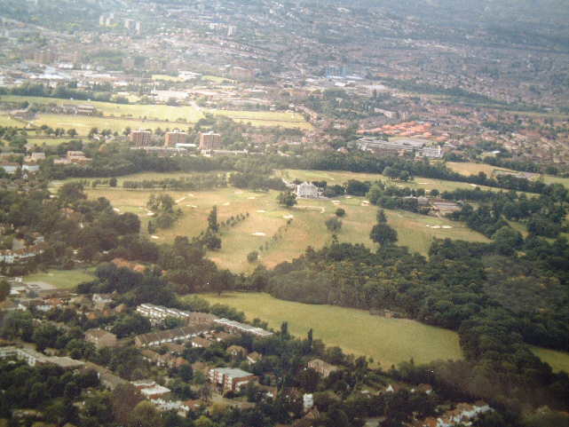
Aerial photo courtesy of Bill
Hodgson, circa 1992
A summary of the Parks creation
1623 - A map of the Manor of Beckenham is drawn which helps determine that the current park is not within that Manor
1720 - A map of Foxgrove Manor is drawn for the then landlord Lancelot Tolson which includes the area of the park, copied in 1766 for Jones Raymond of Langley
1745
John Rocque produces a map of London and surrounding area which shows a
‘messuage’ on Stumpshill, described as
Stoms Hill on his map.
1757 John Cator is described as buying land at Stumps Hill from Francis Valentine
1759
John Cator, Peter Burrell and Jones Raymond acquire an Act of
Parliament allowing them to exchange land. Cator owned Stone Farm
between Kelsey and Langley and several nearby sites.
1760 (circa) John Cator had acquired the site of the mansion and some other fields in the Manor of Foxgrove and builds a fine stately house by 1762.
1762
John Cator's father in law Peter Collinson describes John's house and grounds at
Stumps Hill
1766
- A map of the Manor of Foxgrove shows that the Park is almost wholly
within Foxgrove and John Cator already has some fields in his name.
1769 Andrews, Drury and Herbert’s map shows Cator's house with a similar footprint to the current mansion on the site of the Rocque ‘messuage’
1773 John buys the lands of the Manor of Beckenham from Viscount Bolingbroke but the purchase is fraught with problems until 1780, very little of Manor of Beckenham land becomes or remains part of the Park.
1777 John buys or exchanges more fields called Pill Crofts and Hop Ground adjoining his house property from Amy Burrell, widow of Peter Burrell II
1778
Edward Hasted publishes his first edition of The History and Topography
of Kent. First printed record of Beckenham Place. Some accuracy
questioned.
1785 John closes roads crossing his estate and diverts the Beckenham to Southend road enclosing (enparking) his ‘park’. The lake may have been constructed or extended at this time.
1793 John exchanges land with Peter Burrell IV, Lord Gwydir to consolidate his estate this may have had some impact on the size of the ‘Park’
1799 An Ordnance Survey map drawing shows the park and the house footprint without a portico
1806 John Cator dies and his nephew John Barwell Cator and family 'trustees' inherit and is believed to embellish the house and grounds with the portico and change to the lake outline.
1817 to 1933 A series of tenants occupy Beckenham Place (updated; first recorded tenant 1817)
1825 John Barwell Cator and trustees in the Cator family acquire a Private Act of Parliament which allows changes to the estates
1900-05 - Boys School, Craven College
1906-1933 - Norwood Sanitarium under Dr. Hare and Foxgrove Club Golf Course opened.
1927 – The London County Council decides to buy the park from the Cator Estate.
1929 – Opened as a Public Park
1933 – Golf course made the first Public Golf Course
1972 – Ownership passed to London Borough of Lewisham.
A “Short Story” account and timeline is also available on the Friends of Beckenham Place Park website but this fuller illustrated version is hoped to be more informative.
The history of Beckenham Place Park is still shrouded in much mystery even though several local historians have recorded many facts about the place. It has become a jigsaw puzzle of facts, assumptions and some guesswork.
A pivotal period in its history is between 1757 and 1785 and even later when John Cator the Younger (1728-1806) began to acquire the lands and manorial rights of a sizeable area around and including the current park. The site of the Mansion came into Cator's possession as early as 1760 but the whole current public park area did not until after 1777 and some parts possibly as late as 1795 although he had vast land holdings outside of the park area. Some of these holdings enabled him to exchange land with other landlords to construct a contiguous estate. After his death in 1806 and from 1825 onwards his heirs began a long period of leasing or selling off parts of the estate which we will explain later. The remaining, now public park, house and buildings, are the remnants of the estate. Sadly some of it much decayed, neglected, destroyed or altered.
It is now evident that the Public Park is almost entirely on land once belonging to the Manor of Foxgrove apart from a narrow strip alongside Beckenham Hill Road from the Manor of Beckenham. This was referred to by Eric Inman in the mid 1990’s but not fully explored or explained. John Cator acquired some land at Southend, Lewisham in 1757. He must have been purchasing land around the area for some time because in 1759/60 he exchanged other lands he had acquired around Langley Park in Beckenham for some parts of the Manor of Foxgrove from Jones Raymond of Langley and Peter Burrell of Kelsey long before the previously assumed 1773 dating of the mansion. This will all be clarified in the timeline later but mention of the previous owners of Foxgrove is relevant as it is the main location of the park.
Hasted's History and Topography of Kent, second edition published in 1797 records some if not all of the people through who's ownership the land constituting the park and surrounds passed. Current research reveals some possible errors in Hasted’s account but as he was publishing work related to the whole of Kent he can be forgiven. Ownership did not always imply occupation as houses, estates and farmsteads were leased. For example, the Burrells had interests in Surrey and Lincolnshire, The Raymonds in Essex, The Bolingbrokes in Battersea and Lincolnshire, the Cators came from Herefordshire and subsequently went to Norfolk. Rockinghams had estates in Yorkshire and Northamptonshire and became linked to the Sondes family/Lees Court estate in several parts of Kent. Some landowners may never have set foot on parts of their property. There are some errors in Hasted’s and perhaps all histories and I expect there are some here too but I attempt to be as accurate as possible.
I am always open to new information and corrections that can be substantiated and still conducting my own research. More recently, Keith Baldwin has contributed research clarifying and extending detail on some events. Checking the version number of this file will tell you if amended versions have been published. Errors exist in several histories i.e. Hasted has some transposed dates and names and others did not have access to some archives. Both Borrowman and Copeland comment that errors are possible and historians can only report what they find. I admit that errors on my part can occur here and I have tried to draw some indicative conclusions that may not be wholly accurate.
It
should be noted that some conclusions drawn by various people and some
leaps of faith may have slightly misconstrued some evidence. The lack
of full documentary evidence is frustrating although many other
archives hold evidence e.g. the papers of Hester Thrale, the letters of
Peter Collinson, memoirs of Doctor Samuel Johnson and James Boswell,
Memorials of John Bartram and Humphrey Marshall, Diaries of Fanny
Burney (Madame D'Arblay), Thraliana by Hester Thrale/Piozzi etc. etc.
Of late we have the advantage of several archives being opened to the
internet via online catalogues as well as several books being published
as e-books e.g. Hortus Collinsonianus, Memorial of John Bartram and
Humphrey Marshal, Memorial of George IV etc. Unfortunately, even in
this
digital age, not enough material is available or catalogued in enough
detail to make all evidence easily accessible.
You can conduct your own online research using keywords in various combinations: Cator, Collinson, Thrale, Johnson, George IV, Burney, Boswell and others from the text here but beware of the errors and misconceptions in some of the material which we challenge here.
The Cator family descent associated with Beckenham Place bearing in mind that other members of the family were involved in management of the estate as trustees, or under what we would call power of attorney.
John Cator the Elder 1703-1763 His retiring to Bromley may have influenced the family settling in Beckenham
John Cator the Younger 1728-1806 (died without issue) Acknowledged as the builder of family fortunes and Beckenham Place.
Joseph Cator 1733-1818 (John’s oldest surviving brother) his family branch became the landlords
John Barwell Cator 1781-1858, son of Joseph, instigated the move to Woodbastwick, Norfolk
Albemarle
Cator 1813-1868 lived for the most part in Trewsbury or Ireland
Albemarle Cator 1836-1906, his elder brother John Cator 1830-1859 died before inheriting and without issue. This Albemarle was of unsound mind in later life and others managed the estate affairs.
John Cator 1862-1944 would be the John Cator mentioned the conveyance of the park to the LCC
Later family heads were or are Henry Cator, John Cator, Albemarle Cator
The
backdrop against which Beckenham Place was created should be viewed
alongside the events and conditions of the times. Beckenham was a small
village within a rural setting of farms and estates. There were a few
large landowners with tenant farmers and workers, also, some
smallholdings and private houses, some of which were described as
mansions or great houses. With a small population recorded as 1,000 in
1801 which rose to 26,000 in 1901 development was slow. The large
landowners were either long term family inheritors or people who had
purchased estates as a means of ‘banking’ their wealth. However, the
estates did change hands fairly regularly and the landowners’ names are
also associated with estates elsewhere so Beckenham was not by any
means a sole family seat for many. The long term landowners
included the Leighs of Addington who inherited Foxgrove Manor, the St.
Johns of Beckenham Manor from circa 1650 who’s main base was in
Battersea, the Brograves of Kelsey and the Styles of Langley. The
Burrells arrived in the late 17th Century acquiring the Brograve property and the Raymonds in 1732 took over from the Styles.
Wealth accumulated from business was often invested in land purchase
which in turn generated rents and other income.
Often the absence of an heir led to sale of estates as with the Styles of Langley who descended into the Elwills, or heirs favoured other places and sold their Beckenham property as with Bolingbroke in 1773 and the Burrells in 1820, and indeed the Cators gradually from about 1808. The histories written by Thomas Philipott (1659) and Edward Hasted (1797) relate the chain of exchange of ownership but these also miss some fine detail. Other significant landowners were the Tolsons, Motleys, Austins, Batts, Pughs, Willis, Humphrey and Lethieulliers. Maps and land deeds discovered show the patchwork of fields and estates with ownership jumbled in some cases. Large estates were divided into farms with for example Langley being divided into 4 or 5 farms all but one being leased to tenants. In 1736 Thayers Farm and Elmers End Farm were owned by Thomas Motley who also owned a fine house and grounds in Beckenham village. Around this time the Lethieulliers owned Kent House Farm and the site of Clockhouse. A few generations later and the land was either left or sold to others.
Several if not all the large landowners had contact and involvement with either the South Sea Company or East India Company, sometimes both. These were investments and sources of income and wielded significant power. Often the landowners were members of parliament not necessarily for Beckenham but for other areas ie the Burrells for Haslemere and Cator for Wallingford and Stockbridge. Being a member of parliament and a member of the South Sea or East India Company enabled them to influence decisions in favour of their interests. Some smaller land or property owners had businesses such as Dying and Tanning in London or Southwark, just as the Cators would start with a timber business.
The 18th century was one of turmoil both domestically and internationally with wars between Britain and France, such as the War of the Spanish Succession, The 7 Years War, The war of American Independence and the later Napoleonic Wars. The social conditions bordered on the barbaric both domestically and internationally. Felons could be transported to the Americas up to the time of the American Revolution and to Australia thereafter or hung for quite minor offences. The working class, poor and slaves were all treated harshly. Felons could be transported into slavery and apprentices were indentured for 7 or more years into a situation of ownership by their masters. Although living conditions were more comfortable for the wealthy life expenctancy could be cut short by a plethera of diseases and local families had their share of premature deaths.
Though some claims have been made that the Cators as Quakers suffered persecution, that persecution often was only in the form of fines for not attending the recognized Church of England or for not paying tythes or taxes and it seems that the nonconformists could in most cases afford the fines levied upon them. Ironically after John Cator the Elder's death in 1763 the rest of the Cators embraced the Church of England as Cator's widow and several children were baptized. Hence, the family tombs in St.George's churchyard. Some comparisons brought up by this account show that Frederick St.John, Lord Bolingbroke entered into a subterfuge with Cator amounting to thousands of pounds with no penalty whereas someone stealing a couple of window frames was transported for 7 years and others sentenced to death for theft of low value goods. Earlier in 1720 several notable persons committed large frauds and embezzlements under the South Sea Bubble affair and in most cases quite minor financial penalties were applied.
Beckenham was one of many places easily in reach of London but away from the pollution and dirt of the City and hence a place to have a country house. Admiral Sir Piercy Brett moved into Clockhouse in the mid 18th Century and John Cator’s brother Joseph moved in after Brett’s death in 1882.
Frederick St. John had married Diana Spencer but his debts and broken marriage led him to dispose of estates in Battersea and Beckenham.
The Cators probably were regarded as middle class 'yeomen' in Hereford as landowners and perhaps John Cator’s later great wealth only raised him to the nouveaux riche. But the family followed the format for the time with the primo geniture male heading the estate and the younger sons entering the army, navy and church or maybe some business to seek their own fortune although the family were trustees of the estates. London then as now was seen as a place where fortunes could be made and was a magnet for people from the four corners of Great Britain and beyond. Those who attained wealth were prone to follow fashion in terms of their domestic and social arrangements. Cator had a desire for climbing the social ladder and some of his acquaintances seemed to either admire (Samuel Johnson) or despise him (Fanny Burney) for it.
Investing money in a landed estate which brought in rents from tenant farmers and house rents was akin to ‘buy to let’ as it is carried on today. Even the middle class and aristocracy often rented property as opposed to buying it.
The
Cators, although owning Beckenham Place and later Woodbastwick in
Norfolk often favoured other places to live and one of the Albermarle
Cators decided to move to Trewsbury while still owning Woodbastwick. It
seems both Woodbastwick and Beckenham Place were leased during this
period. At least two generations of Cators married wives from Irish
families and significant time was spent in Ireland with several
children being born there.
For some background I would recommend ‘London Life in the Eighteenth Century’ by M.Dorothy George, which is probably out of print, as being well researched and probably used since as source material by other authors.
Pre-history to the Medieval Period
Evidence in the landscape shows that geologically the area was under a shallow sea 54 million years ago in the Eocene period as in some areas the Blackheath beds or Harwich Formation of shingle emerge through the London Clay. In one area of the park there is a conglomerate (concretion) of the Blackheath beds which is shingle cemented together with lime and sand. In other areas the London Clay is on the surface covered with a thin layer of topsoil being leaf mould or silt deposits. The geology would affect the later use of the land and economy. Locally there have been brick fields utilising clay and sand, gravel pits and lime kilns all using the natural resources laid down geologically.
During the Mesolithic, Bronze and Iron ages there was probably occupation as although no definite remains have been found so far there are hill forts and earthworks within walking distance at Keston, Halsted and Westerham, also some mention of flint tools found near West Wickham.
During
the Roman occupation of Britain a road passed through the Beckenham
area en route from Lewes in Sussex to Londinium. Though no hard
evidence has been found in the park or close by it is projected by some
experts that the road cut across the corner of Beckenham Place Park
near the Foxgrove Road Lodge at the junction of Foxgrove Road and
Southend Road. Different projections for the route of the road exist
and as Beckenham has been redeveloped several times I would have
thought more evidence would have surfaced, literally. Also, althought
the road deviated to cross the north downs it is projected to have gone
straight up Spring Park at West Wickham which would have been a
challenge for loaded horse drawn carts of Roman goods. The suggested
area is now outside the public park and under an area of private
housing. Roman remains exist not far away at Keston, Titsey and
Orpington. In the area where the roman road is projected to have
crossed the park before the park was established there was a quarry or
gravel pit and a lane called Limekiln Lane maybe indicating that there
were lime rich deposits or chalk here. Whether these were part of the
Blackheath Bed conglomerate or underlying Chalk near the surface we
cannot say. I’m told the chalk would be about 100 feet/30metres below
the surface. As much of Beckenham has been redeveloped more than once
it is curious that no historic remains have been found. The Roman road
structure was said to have been mainly gravel and as the area is
largely of gravel composition then over time the road may have fallen
into disrepair, the course became obscured and diversions created
around areas which may have become impassable. Also we have to consider
the local waterways, although not considerable, would have required
crossing with bridges or fords and this may have caused the road to
deviate from the accepted Roman practice of building straight roads
wherever practical. One source suggests the road crossed what is now
Langley Park Golf course and may have gone through Kelsey Park. Some
local roads though not straight do approximately follow these lines.
Various landlords had roads diverted around their estates and the
various stages of settlement and farming could have erased or buried
many features. The course of the road is plain to see through
Edenbridge and several other places but does not seem to have survived
in any form through Beckenham.
The Ancient Pond in the park which is about 100 yards from the front of the mansion is so far undated but was there in 1785. We know from map evidence there was a building or farm predating the mansion on this site the pond may have been related to the previous buildings, or it may have been the result of excavating clay for brick making or may date back much further. What is most probable is that there is a spring at the edge of the pond as it is always full and old OS maps show other springs and ponds near the top of Stumps Hill. A small water-course was used as the Parish/Borough boundary between what is now Bellingham/Sedghill School and the Manor of Beckenham
Unfortunately, very little survives locally of any Ango-Saxon, Medieval, Tudor etc. One of the oldest structures is the lych gate of the church and that’s a bit like Trigger’s broom, 3 new heads and 2 new handles! It is said that parts of the Old Manor house survive in the facade and interior of the building there opposite the church which is now a restaurant. Even the church was rebuilt in the Victorian period after fire damaged the previous medieval incarnation but some old memorials remain. The Alms houses next to the church and the George Inn are dated to the 17th century. The Anglo-Saxon administration survives in the old maps as the Park is in the Hundred of Bromley and Beckenham which is in the bailiwick or Lathe of Sutton at Hone. The works of Thomas Philipott revealed an ever changing web of ownership, intermarriage, selling and transfer of properties all over Kent. In some cases estates were handed out by the Crown only to be seized again when some misdemeanour took place e.g. The Boleyn’s having Hever confiscated by Henry VIII after Anne Boleyn’s alleged adultery. The manors and estates around Beckenham are no less a case in point, some of which is explained in the following timeline.
The Reverend William Rose had a Georgian rectory built to an Adam Brother's design but that gave way to a town hall and now a branch of Marks and Spencer and its car park which cover the site.
Perhaps the George public house in the high street is the oldest most complete structure locally and that passed through the hands of the Cator Estate and is listed in the 1825 Act properties along with the Crooked Billet in Penge.
Those are some of the unknowns which await discovery of firm evidence.
1334 Lay Subsidy Roll Taxation record This source of information may not directly relate to the Park but could give some clues to the derivations of local names. In the list of names we find John and Ralph Stomeshulle from which could be derived Stumpshill, Cleyhurst is perhaps a basis for Clay Hill, Langele as the source of Langley and Eylmer for Elmer. Then it gets less obvious: ie Hauek for Hawk as in Hawksbrook? The Roll has 48 names for Beckenham paying a total of £7.30 in tax.
Some
of the names in the Lay Subsidy Roll are mentioned in Philipott’s and
Hasted’s histories, such as Bruyn and Langley. We are at the mercy of
other researchers who may find and publish other records bearing in
mind that information may be in old English or even Latin.
1369 Enfeoffment The Kings College Archive at Cambridge University has document from 1369 which is an enfeoffment for land including Foxgrove: Enfeoffment by Bartholomew of Burwash to Walter Parely, knight, William Steel, Wlliam de Wyndrove, clerks, Thomas Hungerford and John de Gildesburgh, of manors of Braundon (Warwickshire), Haydor (Lincolnshire), Grantchester and Barton (Cambridgeshire), Plumsted, Foxgrove, Hendon, Chedingstone (Kent), Burghersh, Byssh (Sussex), Kersatton (Surrey), Crakemersh (Staffordshire), Boxworth advowson (Leicestershire), hospital in St Peters Parva by Pouleswaif (London) and reversions of manors of Sibelithingham (Essex), Mildenhale (Wiltshire) and Bekeswell (Essex). The seal of Bartholomew of Burwash is attached. Enfeoffment is the granting of land in exchange for a pledge of service. Maybe to provide men at arms but I can only guess at the service to be provided.
From 1334 to 1700 Manor of Foxgrove
The remaining records show that up to the mid to late eighteenth century the area occupied by the present Beckenham Place Park was a patchwork of woods and fields straddling the Lewisham and Beckenham parish boundary. Most of it was part of the ancient Manor of Foxgrove. It was bisected by two public roads leading from Southend to Beckenham and Southend to Clay Hill (near Shortlands) respectively. This is illustrated by maps of 1766 and 1768 shown later.
Hasted says about Foxgrove (drawing on Thomas Philipott):
Bartholomew de Burghersh died seised of it in 1354:. (see the enfeoffment in previous paragraphs)About the year 1510, it came into the family of Baversea. Humphrey Baversea aliened it to Luke Hollingworth, who, about the year 1547, sold it to Sir John Olyffe whose only daughter and heir married John Leigh, Esq. of Addington, in Surrey. From him, it descended to Sir Francis Leigh, who died in 1711, having directed this and other estates to be sold. This farm was purchased, in 1716, by Mr. John Tolson, and descended to Lancelot Tolson Tilly, who devised it to Timewell Brydges, Esq. for his life, with remainder to John and Edward Brydges, of Wotton. In 1765, it was sold by the Brydges's to Jones Raymond, Esq. who died in 1768,(editors note: by this time Cator had acquired the site of the Mansion in 1760 and Raymond exchanged land with Cator in 1760 casting doubt on the 1765 date) having left this estate between Amy his sister, relict of Peter Burrell, Esq. and William and George Evelyn Glanville, Esqrs. the sons of Bridget, another sister. Mrs. Burrell, having purchased their share, became possessed of the whole. She died in 1789, when this estate devolved upon her son, the late Sir William Burrell, Bart. who sold it to his nephew, Sir Peter (now Lord Gwedir). Sir Peter Burrell exchanged it, in 1793, for other lands, with John Cator, Esq. who is the present proprietor.
But we find even this is perhaps a bit of a generalisation or even some form of misprint. Various old estate plans show land owned by Tolson (or Toulson) alongside land owned by the Burrells, the Tillys and others. The Wills of landlords throw some doubt on some details of Hasted’s account as will be indicated in the Timeline from 1716 to 1760.
Definitions: Seised; having possession. Devised; disposed of through a will. Aliened or alienated; transferred by sale or other means.
We should compare Hasted’s account with Thomas Philipott’s earlier account below from 1659 with the original spellings.
“Foxgrove is the last place of Account in this Parish (Beckenham), it had in elder times Proprietaries of this Sirname; for I find John de Foxgrove paid respective Aid for it in the twentieth year of Edward the third, at making the Black Prince Knight. After this Family succeeded Bartholomew Lord Burwash, and he held it at his Decease, which was in the twenty ninth year of Edward the third, Rot. Esc. Num. 44. and from him it descended to his Son Bartholomew Lord Burwash, who in the forty third year of the above said Prince, passed it away to Sir Walter de Paveley, and in his Family it remained untill the latter End of Richard the second, and then it was conveyed to Vaux of the County of North-Hampton, and there made its abode untill the latter End of Henry the sixth, and then it was alienated to John Grene Esquire, and he died possest of it in fourth year of Edward the fourth; and in this Family did the Title reside, untill the Beginning of Henry the eighth, and then it was demised to Beversea, and Humphrey Beversea, I find held it in the eighteenth year of Henry the eighth, and his Descendant passed it away to Luke Hollingworth, and he about the Beginning of K. Edward the sixth, sold his Interest in it to Alderman Sir Jo. Oliff of London, and he dying without Issue Male, Joan matched to John Leigh of Addington Esquire, was his sole Heir, and in Right of this Alliance, did it come down to Sir Francis Leigh late of East-Wickham; whose Widow Dowager the Lady Christian Leigh, is now in Possession of it.” His account only takes us up to 1659.
Subsequent to this, as Hasted recounts, Francis Leigh 1651-1711 directed that Foxgrove and other land at Plaistow be sold by his Will. But we find Hasted's description is a little confused according to evidence uncovered here. Hence, John Tolson bought the land, and it descended by complicated means to his nephew, Lancelot Tolson Tilly, who dying young, left it to his parents who in turn left it in parts to Lancelot Tolson Tilly’s widow Elizabeth who in her turn left her part to Joseph Grove her uncle. Another part was left to Deborah Brydges (married to Reverend Edward Timewell) and a third part to John and Edward Brydges. The timeline will explain more fully. For those interested in genealogy it’s a complex story and this branch of the Leigh family is connected but different to the branch at Addington. The wills and bequests of the Tillys certainly confuse me and I am discussing the processes with another researcher. It remains the case that some land acquisitions of John Cator cannot be dated other than by his assets listed in the 1825 Private Act of Parliament.
Expanded Timeline: earliest
records to the present
Thomas Philipott and Edward Hasted are perhaps the best sources for information up until 1700 with some comparison to Lysons Environs of London. Their works cover all of Kent so lack some fine detail but relate events buried in ancient documents. This work explores events mainly from the late 17th century with earlier material from Philipott, Hasted and various archives. Both Hasted's and Philipott's works have been challenged in some respects. Our other page about Beckenham has some earlier and additional references or refer to the pdf files in the introduction at the top of this page.
1066 - From the Domesday survey of 1086 we have a record of the Manor of Beckenham which at that time may have included what later became Foxgrove, Langley and Kelsey but as land held by the crown and church was not recorded in Domesday then those lands may have been held by either institution. Some land was possibly held by the 'villagers' or freemen described in Domesday.
1086 - From Domesday until later we only have some references to the Manor of Beckenham for which see our 'Beckenham' history page
1274 - First reference to the name Foxgrove in an inquisition.
1334-35 - The Lay Subsidy Roll mentions family names perhaps linked to current place names ie. Stommeshulle (Stumps Hill), Cleyhurst (Clay Hill). And Bruyn, Langele, Langley.
1369 - The Kings College Archive at Cambridge University has document from 1369 which is an enfeoffment for land including Foxgrove: Enfeoffment by Bartholomew of Burwash to Walter Parely, knight, William Steel, Wlliam de Wyndrove, clerks, Thomas Hungerford and John de Gildesburgh, of manors of Braundon (Warwickshire), Haydor (Lincolnshire), Grantchester and Barton (Cambridgeshire), Plumsted, Foxgrove, Hendon, Chedingstone (Kent), Burghersh, Byssh (Sussex), Kersatton (Surrey), Crakemersh (Staffordshire), Boxworth advowson (Leicestershire), hospital in St Peters Parva by Pouleswaif (London) and reversions of manors of Sibelithingham (Essex), Mildenhale (Wiltshire) and Bekeswell (Essex). The seal of Bartholomew of Burwash is attached.
Enfeoffment is the granting of land in exchange for a pledge of service. Maybe to provide men at arms but I can only guess at the service to be provided.
1479circa – William Brograve of Kelseys in possession of lands around Kelsey in Beckenham.
1484 – The Manor of Foxgrove is mentioned in Records of the Exchequer at the National Archive, Kew. Parties: Richard Middelton, Esq., Lady Maud Grene his wife, and Thomas Grene, Esq & Margaret Kyng, widow, farmer of the manor of Foxgrove in Beckenham; Place or Subject: The manor of Foxgrove in Beckenham (Bekenham), [Receipt]. County: Kent
1500circa – Nicholas Brograve (of Kelseys) is involved in Chancery cases concerning property.
1530circa - From Hasted’s history of Kent he relates that Thomas Philipott had recorded in his history of Kent that “Charles Brandon, Duke of Suffolk, son of Elizabeth Bruyn, by her second husband, resided in the manor-house of Beckenham as lessee; and that he entertained Henry VIII there, "with all the cunning pompe of magnificence, as he went to bestow a visit, at Hever, on his discarded and repudiated wife, Anne of Cleve"
For clarity this is the old manor house opposite St. George’s Church and not what we refer to as the Mansion in Beckenham Place. John Cator styled the house in the park as his Mansion because when he acquired the Manor of Beckenham lands the old Manor house had already been exchangedsold previously to the Burrell family by Lord Bolingbroke.
Hever had been the home of the Boleyne’s but after Henry VIII had Ann Boleyn or Bullen and her brother executed he confiscated Hever and subsequently rented it to his fourth and ex-wife Anne of Cleve. Occasionally Anne of Cleves gets confused with Ann Boleyn because of the Henry VIII connection. Philipott’s version is the earliest we have rediscovered at this time which describes Beckenham in any detail. The Anne of Cleves story cannot be confirmed so far but an interesting connection may relate to Langley where oak panelling depicting Catherine of Aragon was found and sold to the Philadelphia Museum of Art circa 1930. Humphrey Style of Langley has been described as a squire of the body to Henry VIII and this also cannot be confirmed.
Philipott writes of Hever: “Hever in the Hundreds of Somerden and Ruxley, had in elder Times a Castle, which was the Capital Seat or Mannor built by Thomas de Hever, who had liberty by the Charter of Edward the third, granted to him in the fourth of his Raign, not only to embattle his Mansion here, but likewise had Free-warren annexed to his Lands in this place. William Hever deceased without Issue Male, and left only two Daughters and Co-heirs; Joane married to Reginald Cobham of Sterborough, and the other wedded to Brocas, whence in Records it is sometimes called Hever Cobham and Hever Brocas, and when the Cobhams went out, the Bullens were the immediate Purchasers; for Geffrey Bullen purchased this Place, and his Grand-child Sir Thomas Bullen Knight of the Garter, and Earl of Wilts, lived here, who was Father to Anne Bullen, Wife to Henry the eighth; and as he had here his Habitation, so likewise he has here his Sepulcher, and lieth emtombed in Hever-church; but when his Son George Viscount Rochford, upon pretence of some black Crimes acted against the Majesty of Henry the eighth, fell under the Censure of High Treason; this upon his Attainder or Conviction was escheated to the Crown, and began to be reputed a Mansion of some Estimate, when Anne of Cleve for some Time lived here, and made it her residence; but, in Times subsequent to this, I find it eminent for nothing, till King James granted it to Sir Edward Waldgrave, whose Successor yet possesses it.”
This just needs a bit of clarification but of no impact on our history of Beckenham Place. However, maybe it’s an example of how information becomes distorted, confusing the two Anne’s associated with Henry VIII and Hever. Hevercastle.co.uk states: In 1540 Henry VIII married his fourth wife, Anne of Cleves. Henry’s decision to marry Anne was based on a portrait miniature painted by Hans Holbein. The marriage was made for political reasons but ended in divorce six months later. Henry VIII awarded her the honorary title of ‘The King’s Sister’, £500 a year, a sufficient household and two houses. In addition, he allowed her to lease a number of manors to enhance her status and income, including Hever, at an annual rent of £9-13s-3½d. Anne settled happily in England and became good friends of the King and Anne Boleyn’s daughter, the future Queen Elizabeth I.
Anne had Hever Castle until her death in 1557 but it is not known how much time she spent at the castle. However, there is a surviving letter written by Anne to Mary Tudor in 1554 signed ‘from my poore house of Hever’.
Henry VIII took Hever from the Boleyne’s or Bullens as Anne Boleyne had been accused of adultery with her brother etc.
1590 - The Will of Izarde Curtis or Curtys of Beckenham, widow of William Curtys, is reported as recording " my house and lande within the pische of Lewisham called Stumpeshill" (source: R.Reed) 'pische' is an abbreviation or spelling of 'parish' which is found in other wills. Whether this refers to property on the site of the current mansion is speculative but may be supported by indications of buildings on Rocque's map of 1745. At present it is the earliest written indication we have for buildings on or near the site. Frustratingly, wills and property deeds often lack any map or detail to allow for identification of land.
1613 – Several early maps of Kent are on record showing Beckenham identified by a church or manor house but the only other detail is Langley placed between Beckenham and West Wickham.
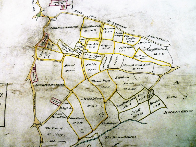
Matching
the plan against the Foxgrove Manor plan and more modern maps also
shows that very little Beckenham Manor land is in the current park. It
would seem that only the edge of Stumps Hill Wood was in Beckenham
Manor. The land to the left of the outlined section marked Sir Francis
Leigh is part of Foxgrove Manor which becomes Beckenham Place. The
Church and old Manor House are marked.
Courtesy
of the British Library © this is a section of the map excluding parts
near
Penge, Crystal Palace, Kelsey and Langley
Transcript of the map legend:
The Plot of the Manor of Beckenham with the Demesne Lands Woods Pastures Meadows and Brooks unto the same pertaining now used and belonging situate lying & being in the said Parish of Beckenham In the County of Kent. And is now the Manor Land etc. of Two Men as yet un-divided (that is to say?) Henry Snellyer (aka Snellgrave?) of the Parish of Beckenham aforesaid his own part) or Moiety. And Sir John Dolston (sic Dalston?) of the Parish of Dolston in the County of Cumberland Kt. the other part or Moiety As... is inscribed and plotted one Tenement or Farm and the Land unto the same belonging being also in the said Parish of Beckenham called the Abbey and is coloured about in Yellow. Being the said S. Henry’s own tenement and Land and now Leased out unto Richard Baldwyn of the same Yeo. All which said Manor and Tenement and the said several Lands etc. were at the Request of the said Sir Henry Snellyer. Measured and Plotted in the month of November in the year 1623. By Nicholas Lane. Supervisor.
T. Proudlove. TransferiRfit. 1768
Sir John Dalston is traceable on History of Parliament online. The land called the Abbey was between Penge and Rockhills (what is now Crystal Palace)
The
descriptions of how the Manor of Beckenham descended through various
landlords
differ widely between Philipott and Hasted's accounts. They can both be
read online. If Hasted carried out further research based on
Philipott's earlier account then we may take it as more accurate but
perhaps both need consideration along with reference to Lysons.
More modern sources challenge all three accounts.
1639 - Henry Snellgrave dies, grandfather of the Henry who will sell his part of Beckenham Manor to the St.Johns. His will is lengthy and describes the manor and advowson of the church, leaving income from his lands to his eldest son Thomas for his lifetime but also then leaving the manor to his grandson Henry by Thomas.
1642 - Oliver St John dies, who is said to have purchased part of Beckenham Manor from Sir Patrick Curwen or Curwin (d.1664), MP for Cumberland.
1643
- During the Long Parliament under Charles I, Sir Patrick Curwen and
Sir George Dalston were Royalist MP's who were disabled (excluded from
Parliament?) in this year for their Royalist loyalties. Both MP's for
Cumberland they had a long association the families being connected by
marriage and whether their presence in
Beckenham was to have accommodation close to Westminster during their
time as MP's remains a possibility. But more likely is the inheritance
of their part of Beckenham Manor descended via the Tyrrell family.
1644 - LEIGH, Sir Francis II (1590-1644), of Addington, Surrey. and East Wickham, Kent dies. He is the Sir Francis Leigh identified as holding Foxgrove Manor by Thomas Philipott (see 1659 below) also see History of Parliament online. He is the Francis Leigh indicated on the Beckenham Manor map as when Proudlove copied the map he did not update the Foxgrove landlord/s for 1768.
1648 – Surrey Heritage record: Receipt from Henry Snelgrave of Beckenham, Kent, to John Evelyn of the Middle Temple for £2250, the consideration money in a bargain and sale of 13 Jul between Snelgrave and John, George and Richard Evelyn.Witnessed by Robert Abbott, scrivener, his servant Robert Cleton [Clayton] and Thomas Snelgrave. Endorsed as being a mortgage of the manor of Beckenham for three years. With note by William Bray about Abbott and Clayton. [HMC p.678a].
John Evelyn is the diarist of Sayes Court Deptford. We might assume that the subsequent sale to the St. Johns would be to facilitate repayment of the mortgage. This may make me re-assess the records about the ownership and rejoining process of Beckenham Manor? ref 6729/1/32. However, Evelyn's diary records him purchasing another manor from his brother which he sells later in the year and he also visits another of his properties. Similar transactions occur at other times in his diary. He also records meeting King Charles I and the activities of the 'Rebels' meaning the Parliamentarian/Cromwellian troops. So its perhaps surprising that during this time of political and military turmoil that the business of land transactions carries on as normal. Although we may consider that some transactions are brought about by people wanting or needing to realize capital as many Royalists choose to migrate. Evelyn himself spends a lot of time in France and Italy over this period.
This
is however a documentary proof of a transaction.
Evelyn's
diary https://archive.org/details/diaryofjohnevely01eveliala/page/244
"this Mannor as I said before, being annexed to the patrimony of Thomas Tirrell, Humphrey Tirrell his Grandchild to whom it descended, passed away one Moietie of it in the thirty fifth year of Henry the eighth to Ralph Warren, and the other to Henry Parke; Warren alienated his Proportion not long after to Bradbury, from which Family about the latter End of Q. Eliz. it came over by Sale to Serjeant Gent, who gave it in Dower with his Daughter to Sir George Dalston of Cumberland, who in our Memory conveyed it to Sir Patrick Curwin of the same County, and he some few years since sold his Interest in it to Sir Oliver St. John of Batricksey in Surrey, who upon his Decease gave it to his Son then Mr. Walter, but now upon the Death of his Nephew, Sir Walter St. John Baronet, the other Moitie by Joan sole Heir of the abovesaid Henry Parke, came to be the Inheritance of Mr. Robert Leigh descended out of Cheshire, whose Successor about the latter End of King James alienated it to Sir Henry Snelgrave, from whom it descended to his Grandchild Mr. Henry Snelgrave, who not long since passed it away to Mr. Walter, now Sir Walter St. John Baronet, who lately hath exchanged the whole Mannor, for other Land with his Brother Mr. Henry St. John."
I
should repeat, the surviving public park contains very little of the
Manor of Beckenham, only a small part near Beckenham Hill and Calverly
Close. I suspect some of the larger oak trees are surviving boundary
markers between the two Manors, Beckenham and Foxgrove. The mention of
Sir John St. John as landowner on maps later into the 1730’s may cast
some doubt on the actual landowner or occupant of Beckenham Manor
within the St.John family but we have to follow their family tree and
lifespans. As Hasted made some errors it is worth
checking or at least pointing out the map evidence. Or it may be that
John St. John was occupant or tenant while Henry St. John was landlord.
The records in Surrey Archive for 1648 and 1651 listed here, are
evidence of the purchase from Henry Snelgrave of the one moietie by or
through the Evelyns which
contains the manor house, fields and advowson of the church to the sale
to Walter and Henry St. John.
Although the generation of St.Johns of Walter and Henry was extensive,
thirteen children in all, only seven survived past 1650, four of whom
were male. One Oliver St. John who was father to at least two of the
female line which married into this branch of the St. John's was a
Parliamentarian and whether politics played a part in the St. John's
acquiring Beckenham Manor is an outstanding question. But we find St.
Johns on the paternal side being Royalist and the previous landlords of
Beckenham Manor, Sir George Dalston and Sir Patrick Curwin/Curwen were
also Royalist members of Parliament.
Hasted says of the St. John's: Of this family was that ancient branch of the St. Johns, seated at Stanton St. John, in Oxfordshire, which it is probable came first to possess the lordship of Bletsho about the time of Henry VI.'s reign, Sir Oliver St. John then marrying Margaret, sister and sole heir of John de Beauchamp, knt. of Bletsho, a junior line of the Beauchamps of Powick, by whom likewise Lydiard Tregoze, the antient inheritance of the Beauchamps, came into this family. From the eldest of their sons, Sir John St. John of Bletsho, descended the St. Johns, earls of Bolingbroke, now extinct, and the present lord St. John of Bletsho. And from Oliver their second son, of Lydiard Tregoze, descended the present lord viscount Bolingbroke and St. John. He was, anno 2 king Charles I. created lord St. John, baron Tregoze of Highworth, in Wiltshire; and next year obtained of the king the manors of Battersea and Wandsworth, in Surry. He died without issue, in the 6th of king Charles I. by which the dignity of baron Tregoze became extinct, and John, his nephew, the son of his eldest brother, Sir John St. John, became heir to this estate, as well as to that of Lydiard Tregoze, and was first knighted, and then created a baronet, on May 22, 1611, being the 17th in precedency by creation. He was a zealous royalist, having three of his sons killed in the civil wars, fighting for the king. By his firft wife, Anne, daughter of Sir Thomas Leighton of Feckenham, in Worcestershire. He had several children, of whom Oliver, the eldest son, (d.1642) purchased the moiety of Beckenham of Sir Patrick Curwen, and died in the life time of his father, having married Catharine, daughter and coheir of Horatio, lord Vere of Tilbury, by whom he had Sir John St. John, bart. who died before he came of age, unmarried, and was succeeded by his uncle, Sir Walter St. John, in the title of Baronet, and in his estates at Lydiard Tregoze, Battersea, and Wandsworth, and in the moiety of this manor of Beckenham and advowson of the church, of which, having before purchased the other moiety, possessed now the entire fee of them. He died at his seat at Battersea, in 1708, and was interred there leaving an only son Henry, who was on July 2, in the 2d year of king George I. created baron St. John of Battersea, and viscount St. John, and died about the 90th year of his age, in 1742, and was succeeded in the possession of this manor and advowson by Henry St. John, visc. Bolingbroke, his only son by his first wife Mary, second daughter and coheir of Robert Rich earl of Warwick. By his second wife, Angelica Magdalene, daughter of George Pillesary, a French officer under Louis XIV. he had three sons and one daughter; of which sons John, the second, will be mentioned hereafter, as continuator of the male line; the other two died unmarried.
Comparing Philipott, Hasted and the St John family tree it would seem that Hasted could be the more correct. This gives some grounds for reinvestigating the events.
1651 – Surrey Archive: Confirmation of bargain and sale (in return for purchase money) 1) John Evelyn of Middle Temple, George Evelyn of Wotton and Richard Evelyn of Baynards, esqs 2) Walter and Henry St John of Battersea, esqs.Moiety of manor of Beckenham, Kent, and of advowson; also manor house and certain named fields.[This may be a stray from the Evelyn archives introduced by William Bray] -ref LM/351/11
John
Evelyn is the famous diarist of Sayes Court, Deptford. George and
Richard are his brothers. Evelyn's diary of the period records some of
his land dealings, see 1648. This description containing mention of the
church advowson and manor house indicates this is the primary part of
the manor. The other moiety may have been the outlying parts near what
is now Crystal Palace and other fields. When we view the original
document and get field names we may be able to identify the land in
question. John Evelyn spent most of 1651 in France according to his
diary and perhaps his eldest brother George completed the dealings.
1659 - Thomas Philipott writes his “Diligent Survey of the Mannors of KENT: Entituled, VILLARE CANTIANƲM.” Information is later extracted by Edward Hasted for his Topography and History of Kent and Lysons’ Environs of London. (spellings in this tract are as they appear in the publication).
This is Philipott’s passage regarding The Manor of Foxgrove: (repeated from earlier)
“Foxgrove is the last place of Account in this Parish (Beckenham), it had in elder times Proprietaries of this Sirname; for I find John de Foxgrove paid respective Aid for it in the twentieth year of Edward the third, at making the Black Prince Knight. After this Family succeeded Bartholomew Lord Burwash, and he held it at his Decease, which was in the twenty ninth year of Edward the third, and from him it descended to his Son Bartholomew Lord Burwash, who in the forty third year of the abovesaid Prince, passed it away to Sir Walter de Paveley, and in his Family it remained untill the latter End of Richard the second, and then it was conveyed to Vaux of the County of NorthHampton, and there made its abode untill the latter End of Henry the sixth, and then it was alienated to John Grene Esquire, and he died possest of it in fourth year of Edward the fourth; and in this Family did the Title reside, untill the Beginning of Henry the eighth, and then it was demised to Beversea, and Humphrey Beversea, I find held it in the eighteenth year of Henry the eighth, and his Descendant passed it away to Luke Hollingworth, and he about the Beginning of K. Edward the sixth, sold his Interest in it to Alderman Sir Jo. Oliff of London, and he dying without Issue Male, Joan matched to John Leigh of Addington Esquire, was his sole Heir, and in Right of this Alliance, did it come down to Sir Francis Leigh late of East-Wickham; whose Widow Dowager the Lady Christian Leigh, is now in Possession of it.”
Hasted could the report the events of the next 150 years but we can dispute a few details later in this timeline.
1671 – A list of benefactors to the Parish of Lewisham lists: “William Bond, A house at Stump’s Hill, from which nothing is now received. To the poor of Lewisham and Southend “ (source: Lysons, Environs of London). We cannot say if this is a house on the site of Beckenham Place or one near it. The maps of Beckenham and Foxgrove manors indicate a strip of land which lies between the northern part of the two Manor’s lands and another reference mentions ‘woodland between Foxgrove and Beckenham Manors.
1674 - Hugh Raymond's date of birth. He later becomes owner of Langley Park, Beckenham and father of Jones Raymond who will become owner of all or part of Foxgrove Manor much of which eventually becomes Beckenham Place Park. His family came from Saling in Essex and he is referred to as Hugh Raymond of Stepney, Saling and Langley. He becomes a ship’s captain with the East India Company and a director of the South Sea Company. He is later implicated in the South Sea Bubble affair. His story is interesting and deserves more investigation. Several records are in the British Library.
1688 - Peter Burrell I of Beckenham purchases Kelseys mansion and land from a descendant of the Brograves. (source: Hasted). Kelseys is an estate of which part will become Kelsey Park, Beckenham, another public park in the remainder of a private estate. His descendants will acquire parts of Foxgrove Manor circa 1760 through marriage to Amy Raymond, Jones Raymond’s sister, at least until they exchange it with John Cator.
1690
- A Chancery Case Short
title: Burrell v Brograve. Plaintiffs:
Peter Burrell merchant of London. Defendants: John
Francis Brograve. Court of Chancery: Six Clerks Office: Short
title: Burrell v Brograve. Plaintiffs:
Peter Burrell merchant of London. Defendants: John
Francis Brograve esq. Subject: Sale of an estate: Kelsey,
Beckenham, Kent ; Hayes, Kent and Bromley. This would take some
unravelling as the Brograves had several tenants and intermixed with
family names such as Bygrave an Bygrove who may have been related.
(source National Archive).
1692 - Peter Burrell II of Beckenham born, he will become Peter Burrell I of Langley through marrying Amy Raymond (daughter of Hugh Raymond, sister of Jones Raymond). Peter Burrells I, II, and III of Langley can be traced through History of Parliament online as they were all MP's and held various posts. Some confusion is likely as there were four Peter Burrells in Beckenham from the late 17th until early 19th century.
1699 - The birth of Amy Raymond, daughter of Hugh Raymond of Langley, she would become Mrs Amy Burrell and later as Peter Burrell II's widow hold ownership of Foxgrove Manor lands within the park.
The Years 1700 to 1800
This century sees several substantial exchanges of ownership of land in and around Beckenham and elsewhere eventually connected with Cator and the park from the mid-century. The exchanges are due to purchases and sales, inheritance by bequest and some straightforward exchanges of land. There is a background of social interaction which I will refer to but generally the protagonists are written about elsewhere and internet sources can be sought to expand on their stories. Primarily John Cator the Younger creates the park from 1760 and his social and business contacts explain something about the man. But we start from the birth of his father, John Cator the Elder.
1703 – John Cator the Elder (sometimes spelt Cater or Catter) is born in Ross on Wye. They are a Quaker family and their records are in Friends Meeting House registers. His father is a glovemaker, Jonah Cator and there is a modest amount of land owned by the family. He would later live in Southwark and own the timber business. He will become John Cator the younger’s father in 1728 and it is John Cator the younger who will establish Beckenham Place through several land purchases and exchanges from 1757 until his death in 1806. John Cator’s impact spreads from parts of Lewisham, Sydenham, Beckenham, Bromley, and elsewhere in Kent, Surrey and Essex.(Pat Manning’s “The Cators of Beckenham and Woodbastwick” has more details)
1706 - Jones Raymond is born on the 6th November, baptised on the 29th, the son of Hugh Raymond and Dinah/Dynah (nee Jones), he will become landowner, if only for a short time before his death, of parts of Foxgrove Manor and some of what would later become Beckenham Place Park under John Cator the Younger.
Jones Raymond will become a director in the East India Company eventually selling a ship to the Royal Navy which would take part in the Anson voyage to the Pacific which made Anson an immensely rich person through capturing a Spanish treasure galleon. Ironically, the expedition was crewed by sailors from the Naval hospital most of whom would perish on the voyage one way or another. An interesting connection will be that Admiral Piercy Brett who will occupy Clockhouse at Beckenham/Penge borders is a lieutenant on one of Anson’s fleet of ships. And Clockhouse is subsequently bought by Joseph Cator, brother of John Cator the younger.
Hasted mentions two ‘Jones Raymonds’ ie the first one having a son of the same name, but records show there was only the one who died in 1768.
1708 - Sir Walter St. John 3rd Baronet (Lord of the Manor of Beckenham) dies at his home in Battersea. (source; Hasted). Henry 1st Viscount St. John inherits the Manor of Beckenham. It should be noted that in some cases landowners may not have resided in the area. The St. Johns were from Wiltshire with homes in Battersea and Walworth, Bolingbrokes had estates in Lincolnshire and elsewhere as did the Earl of Rockingham and Sondes families (Kent). Some of them were members of parliament of held positions at court and in government so would want residences close to London or Westminster. As previously mentioned, a map of 1736 shows John St. John as either landowner of occupant of parts of Beckenham Manor.
1711 – Francis Leigh of Hawley, Sutton at Hone dies. He is landlord of Foxgrove Manor and several other places but may have been in some debt. His affairs seem in some disarray and his estate is left in the possession of executors of his will. He requests that any remainder after paying his debts, bequests and funeral expenses go to his eldest son also named Francis. The Foxgrove Manor gets sold to John Tolson. Hasted and others had said that Francis requested his estates be sold which didn’t really explain the situation. Hopefully a fuller account of the situation will emerge via records of the Court of Chancery but these are numerous. Later Gazette press releases in 1716 explain that Foxgrove is sold to pay creditors.
1712
– John Tolson purchases Foxgrove Manor presumably from the executors of
Francis Leigh’s will but there is room for doubt. See 1711. Some
clarification is needed as Tolson
leaves unspecified land in Bromley in his will in 1713 but see also
1727
Lancelot Tolson. Foxgrove is mentioned in Chancery Court cases in 1716
in association with paying Francis Leigh's creditors. There is some
question as to whether John Tolson bought Foxgrove or was it his
brother Lancelot Tolson. John
Tolson's mention of a messuage in Bromley could relate to the Plaistow
land which appears on a 1720 map which is subsequently copied. We have
a small gap in substantiating evidence here.
1714 – Bromley Historic Collections record: Covenant to levy fine of 1 messuage, 1 stable, 1 barn, 1 orchard, 1 garden and water yard 15/04/1714 Crabb Grow (8 acres); woodland (2 acres) lying between the manors of Beckenham and Foxgrove, land (1 acre) occupied Thomas Hughes; cottage, orchard yard backside occupied Thomas Stoute and cottage yard backside occupied Richard Steele, at Clay Hill, Beckenham Samuell Adgate of Bromley, yeoman, Thomas Matkins, Citizen of London, joiner, and Elizabeth his wife, and Robert Sutton of London, barber Chirugeon, and Mary his wife. To Stephen Colstone of Southwark, Surrey, plumber, and William Wicker, of Beckenham, yeoman. ref.303/1
It would be tempting to identify the Woodland as the strip of land roughly between the mansion and Beckenham Hill ie Stumpshill Wood. ‘Between’ the manors could mean almost anywhere. See the later Foxgrove and Beckenham Manor maps overlain which show an area between the two. Also the 1785 road diversion plan which I have attempted to identify with possible field names and the 1760 Act of Parliament to exchange land between Cator and the Raymond/Burrell family. It wasn’t unknown for fields to be renamed and there is 46 years gap between this and the 1760 Act.
Crabb Grow or Grove is on the Beckenham Manor map along what is now Bromley Road toward Clay Hill and does become Cator’s at a later date.
Covenant
to levy a fine is part of a buying and selling property process. It
implies one party had not held up his side of the bargain.
Chirurgeon is an archaic spelling for Surgeon.
1716
– Foxgrove Manor which
is
believed to have changed hands in 1712 is subject of a Chancery
case settling
the proceeds of the sale to pay Francis Leigh’s creditors. Sir Francis Leigh of Hawley, in
Kent, on his death in 1711 left
his estates to executors including Viscount Lord Cheyne and William Longueville of Inner Temple to dispose of and settle any
remainder after his debts, bequests and funeral expenses on his eldest
son also named Francis.
They
apparently did not act on the will leaving it to Francis’s wife named
Frances to settle. Whether as executrix she sold
Foxgrove to John Tolson prior to his death in 1713 or it was sold to
Lancelot Tolson about 1716 is subject to confirmation. Nevertheless,
Lancelot Tolson held it at
the time of his death in 1727 and he had been left land by his brother
John.
1718 – The death of Peter Burrell of Kelsey, the first of the four Peter Burrells associated with Beckenham. His son inherits Kelseys, Peter Burrell 1692-1756
1719 - Peter Burrell (the second) is recorded as buying a number of fields seemingly to consolidate his estate. The fields have been identified on the 1735 Burrell map as being around and between the pre-existing estate. The fields named in the document are Wellers, Leasons, Stirt, Little Down and Longs (source: Kent Archive, research K.Baldwin)
(document) appears to date from
about 1720 which appears to read
Wollers 2.5 acres bounding Bromley to Beckenham highway to the south,
lands late of St John West and those late of Lady Leigh North &
East. The vendors
were Thomas Davies of Wapping surgeon, Christiana Davies wife of
William Davies & Thomas Davies of St Dionis Backchurch his only son
and heir in the first part, John Russell of Gosburton Lincolnshire
clerk eldest son of John Russell late of Wapping clerk who survived
Samuel Nicholls late of Wapping woollen draper second part and Peter
Burrell third part £930 also including Little Downes 1a Upper Leazons
7.5a late occ Widow Kempsall, Brenan? Field 1.5a (west of lane leading
to Peter Burrell’s and abutting his land) occ Roger Brown, Longs late
Reuben Musgrave now occ John Walford and Stirt 29a occ Robert Fox –
indenture 1718 for 21 yrs.
1720 - An estate plan of Foxgrove Manor is drawn by surveyor John Holmes. (source: British Library). Though the plan only survives as the redrawn 1766 version by Proudlove (see 1766) it implies that fields and plots aren't much changed. Another map of neighbouring land, Lodge Farm 1720, is in Bromley Historic Collections, showing the landowner on the Foxgrove side as Mr Towlson (Tolson - spellings were often variable and phonetic). I assume the 1720 Foxgrove map was drawn to identify Tolson estates and if it survives may be in some undiscovered archive.
This
is part of the 1776 copy which shows the same landlords as
the 1766 but is easier to read. It does not however illustrate the
outlying parts of the estate of Stone Farm, Plaistow, parts near
Langley and Elmers End etc.
Courtesy
of the British Library, Foxgrove Manor extract
1721 - An inventory is taken of all Hugh Raymond's assets, both business and domestic, to do with the South Sea Bubble affair. The British Library has various records such as: "A True and Exact particular and inventory of all and singular the lands ... and personal estate whatsoever which H. Raymond was seised or possessed of, upon the first of June, 1720 ... Made and delivered pursuant to the late act of Parliament. Together with the abstract of the same ". The officers of the South Sea Company are forced to compensate shareholders, a complex subject that cannot be adequately covered here but Hugh Raymond survives with enough assets to be able to purchase Langley Park in 1732. He will become indirectly associated with the story of Beckenham Place. Hugh Raymond did not own any of Langley at this time but is resident of Saling in Essex, Wapping and Stepney with extensive property assets. Hugh Raymond was also a ship’s captain with the East India Company and other connections with the EIC will become apparent. He had also been a director in the South Sea Company. The Raymond family had extensive estates in Essex and elsewhere.
1723 - Amy Raymond, Hugh Raymond's daughter marries Peter Burrell II of Beckenham and Kelseys who will style himself eventually “of Langley”. The 'Peter Burrells' become confusing as there are four of them associated with Beckenham. Beginning with Peter Burrell of Beckenham (1649-1718), Peter Burrell I of Langley(1692-1756), Peter Burrell II of Langley (1723-1775), Peter Burrell III of Langley(1754-1820) made Lord (Baron) Gwydyr in 1796. Some sources will number them I to IV. History of Parliament online is again a good source of information about them and offices they held etc. This marriage is about 9 years before Hugh Raymond purchases land in Bromley. I believe the links via the East India and South Sea Companies brings the families together.
1723 - A map of Peter Burrell’s estate is drawn by J.Pidduck, copied by Robert Borrowman for his book of 1910. Borrowman copied the map from another copy made in 1829 which was in the Hoare family documents.
The original has just been rediscovered at the Knepp Castle estate in Sussex, the home of Sir Charles R. Burrell, Bt. Possibly relating to the Peter Burrell/Amy Raymond marriage settlement several plans were drawn in 1723. All the properties in this map are south of Beckenham with little or none in the Manors of Beckenham or Foxgrove. By marrying Amy Raymond the Burrells came into line for inheriting Langley Park and parts of Foxgrove later. We know of two maps of 1723 which exist in the British Library of a property near Penge Common and of Woolseys Farm at Clay Hill under the Burrells.
With
thanks to Sir Charles Burrell Bt. of Knepp Castle, East Sussex
who is a direct descendant of William Burrell, a brother of Peter
Burrell of Langley. William Burrell is recorded on the 1769 Andrews,
Drury and Herbert map as residingat Kelseys
 Part
of Borrowman's copy alongside the original at
Knepp Castle
|
 |
1727
– Lancelot Tolson leaves land he inherited from his brother John Tolson
in trust to his nephew, Lancelot Tolson Tilly. This includes Foxgrove
Manor, Stone Farm etc according to Hasted. (This farm was purchased, in 1716,
by Mr. John Tolson, and descended to Lancelot Tolson Tilly, who devised
it to Timewell Brydges, Esq. for his life, with remainder to John and
Edward Brydges, of Wotton. In 1765, it was sold by the Brydges's to
Jones Raymond, Esq. who died in 1768) But John Tolson died in 1713 and had
land in Bromley which was most likely Foxgrove at the time of his
death. The
ownership through the Tolsons and Tillys is complicated not least by
the fact that offspring died before parents and sometimes intestate.
However, studying the wills of the Tolsons and Tillys shows that
land was left by Mary Tilly in three bequests, see 1743. The account by
Hasted leaves some questions not
least the date of 1716 which does match the Chancery Court case
concerning the disposal of Foxgrove by Francis Leigh’s executors to pay
his creditors but that would imply that Lancelot Tolson purchased
Foxgrove, perhaps to extend property his brother John purchased before
1713.
1728 - John Cator the elder marries Mary Brough as recorded on 11th February (source: P.Manning and Ancestry.co.uk). We can now access the Quaker meeting house record via online heritage sites (Ancestry.co.uk). This marriage takes place at the Savoy and Westminster meeting house. John Cator (the elder) is described as a Timber Merchant and so is his father-in-law John Brough of the Parish of St. James, Westminster. John was only in his 20’s and whether he had his own business is questionable, perhaps working for the man who becomes his father in law. Pat Manning records that he had his business on Bankside in 1741. John Cator’s father Jonah is described as a glover late of Ross, Herefordshire also a Quaker. Looking at ancestry records, Ross was an epicentre of Cators, sometimes spelled Cater or Catter. Some Cators were following the established Church of England and others Quakerism, whether they were all the same extended family is a good question. Bearing in mind that the subsequent John Cator of Beckenham Place and his family, although raised as Quakers, were buried in C of E churchyards it seems that changing faith or mode of worship was not uncommon. Though early Quakers were fined for not attending Church and persecuted along with other non-conformist religions, I haven’t found any record of corporal or capital punishment unless one looks at Quakers in America, some of whom were executed by Puritans. As the officially recognized Church of England ran some of the functions now performed by Local Authorities via Parish Councils then avoiding paying money to the church via tithes was perhaps a bit like not paying your council tax and reminiscent of the poll tax demonstrations of more recent times.
Note other spelling ‘variations’ such as publickly. Also, the Quakers followed a different calendar with the year commencing on 25th of March.
Early Friends/Quakers objected to the names of the days and months in the English language because they were of a non-Christian origin. Sunday was called as such by the Saxons because it was the day they sacrificed to the sun. Monday was the day they sacrificed to the moon; Thursday was the day they sacrificed to the god Thor; and so on. Quakers thought it inconsistent for Christians to continue using the names of heathen idols. In an effort to distance themselves from these references, they created their own calendar terms using numbers, which seemed to them to be the most rational approach. Days of the week were known as “First Day” for Sunday, “Second Day” for Monday, and so forth. They used no other names but these, either in their spoken conversations or in their letters. Similarly, the months of the year were known as “First Month” for January, “Second Month” for February, and so forth. If you were a Quaker, you were expected to adopt these practices in your daily life.
Hence, the 2nd month in this record is the month of April (see text).
1728
- John Cator the younger is
born in March to John Cator the elder and Mary Brough (1703 - 1764).
Recorded in Quaker Meeting House registers under Southwark Births, John
Cator the elder (father) identified as of the Parish of Lambeth, Surrey
being
a resident of Bankside? Just outside of Southwark or not yet resident at Bankside is
yet to be confirmed.
John the
younger is
often referred to as being born in Ross-on-Wye which is erroneous
according to this record and perhaps a mistake as the father, John
Cator the elder was from Ross but had become a timber merchant either at Bankside Southwark by this time or working for his father in law. The records show that the birth
took place before the marriage and this it seems was more common than
generally accepted. Indeed, the only methods for monitoring population
growth were from baptisms and burials known as the Bills of Mortality.
Not everyone was baptised and probably not all deaths resulted in a
church burial.
The Quaker records are considered as one of the non-conformist
religions. The Wikipedia entry regarding Bills of Mortality states: It
must be noticed that the record is of christenings, not births; hence
the figures do not include the births of Quakers, Dissenters, Jews,
Roman Catholics, etc.
1732 – Hugh Raymond of Saling and Stepney purchases Langley Park Estate, sold by Edmund Elwill according to Hasted. The Styles, Elwills, Raymonds and Burrells all have memorials in St. Georges Church, Beckenham. Included in the sale of the Elwill/Styles estates is Simpsons Place which was adjacent to Bromley town. Langley straddles the Parish boundary between Beckenham and West Wickham.
1733
– John Cator’s (the Younger) brother Joseph is born. Recorded in St.
Saviours Parish Southwark at the Monthly Meeting of Southwark: Union of
Southwark and [St John] Horsleydown, Friends Meeting House. (from
Quaker records). Joseph will be the father of John Barwell Cator who
inherits Beckenham Place and its estates after 1806 and other siblings
who will be trustees of the estates. Horsley Down is an area of
Southwark/Bermondsey near Tower Bridge.
1735 – Another map of the Burrell estates in Beckenham and Penge reproducing detail from the 1723 map but dated 1735 drawn by John Pidduck. Recently (2019) discovered at Knepp Castle, Sussex the home of Sir Charles R. Burrell, Bt. whose branch of the Burrells descended from Peter Burrell and Amy Raymond via their younger son William who married Sophia, the daughter of Sir Charles Raymond and Sarah (nee Webster). The map is interesting as it records the arrival of Col. Hugh Raymond, spelled Raymund on the map and Penge is spelt Pench, onto the Langley estate which he bought from Sir John Elwill. The map also shows land belonging to Tolson or Toulson and Tilly. This land or much of it will come into the possession of John Cator giving rise to the interwoven patchwork of ownership which would enable later exchanges to consolidate estates. Other detail on the map shows Kelsey with a formal square lake and more detail that could only be related in a small book.
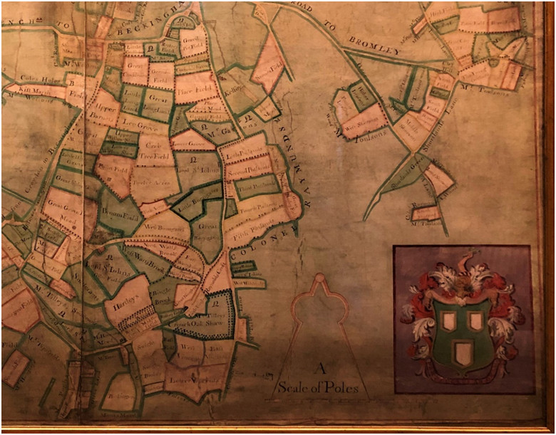
A section of the map from Knepp Castle, courtesy of Sir Charles R. Burrell, Bt. ©
1735/36 - Peter Collinson (John Cator's eventual father in law) meets Carl Linnaeus (Carl von Linne) on Linnaeus’s only recorded visit to England and they become lifelong correspondents on botanical and other scientific matters. An association has been made between Cator, Collinson and Carl Linnaeus the botanist, assuming that Linnaeus contributed to the landscaping of the park. We have gathered evidence regarding relevant dates of birth and death as well as age of the individuals and known movements of Linnaeus indicating this was very unlikely if not impossible. The originating reference to such an event seems to be in Robert Borrowman’s "Beckenham Past and Present" but I believe this to be a confusion arising out of the Collinson/Linnaeus connection. Linnaeus's son later visits London in 1781 in the time of John Cator and we are investigating whether they met. No evidence has emerged so far despite some material relating to Linnaeus the younger being discovered at the London Linnaean Society. Peter Collinson did communicate regularly with Linnaeus by letter. Linnaeus's only known visit to Britain was in 1735/36 when he met Collinson among many others, long before Cator then aged 7 married Collinson's daughter or created Beckenham Place. Collinson enabled Linnaeus to collect various plant specimens and collections. On Collinson's death his books and papers were passed to John Cator and thence inherited by John Barwell Cator, who then enabled them to be copied by the emergent Linnaean Society of London. One of many interesting exchanges Collinson had with Linnaeus and others was the speculation as to where swallows went in winter. It was even thought they might hibernate under water and they discussed experiments to see if this was true involving putting swallows in or near barrels of water. Collinson also discussed electricity with Franklin and the migration of people to America and its impact on the Native Americans. He was a Fellow of the Royal Society and contributed to the establishment of the Foundling Hospital. Having originated from a family home in Peckham he moved to a house inherited via his wife at Mill Hill and established his garden there. It is now the Mill Hill School; see the Mill Hill Society for further information.
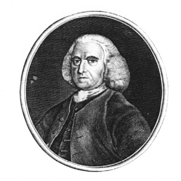
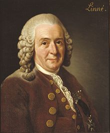
Peter Collinson (1694-1768) Carl von Linne (1707-1778)
1736 – Wm. Brasier produces a map of the estates of Thomas Motley’s Farms at Elmers End, Thayers Farm near Clockhouse and a dwelling house in Beckenham on the cross roads of what is now known as Thornton’s corner. Neighbouring landowners are indicated. Thayers Farm is alongside the site of Clockhouse which would become the place of birth of John Barwell Cator who inherits Beckenham Place in 1806. The Clockhouse site is shown as belonging to the Lethieulliers in 1736. The Cators will later be owners or neighbours of these lands but the map answers some questions about ownership, field patterns and buildings. Other landowners shown are The Hon. John St. John (parts of Beckenham Manor), Samuel Pugh (part of the High Street where he had a mansion) and several borders with the Burrells. The map is also a work of art in its drawing and embellishments and an example of surveyors’ and draughtsmans’ skills. (source; Kent archive).
1737 - Hugh Raymond of Langley, dies and his son Jones Raymond inherits Langley Park, Simpsons Farm and other extensive properties in Essex. Hugh Raymond had purchased Langley Park in 1732 (source: Hasted, Burrell map etc.). The name Jones is derived from Hugh's wife’s maiden name. Her father Samuel Jones was also in the EIC, another ship’s captain. We recently find heritage record evidence that Hugh’s wife’s name was Dinah(Dynah) Jones and Samuel Jones was her father. Again, referring to Hasted's entry for Langley Park can explain detail but we may revisit the history of Langley in a separate account. Jones Raymond is also involved with the East India Company becoming a director. About this time, Peter Burrell was deputy governor of the South Sea Company of which Hugh Raymond was a director. Hasted’s record of the history of Langley would have us believe that Hugh’s son Jones also had a son named Jones but this is an error. I can only find record of one ‘Jones Raymond’ supported by evidence from St.George’s church memorials and birth and death records via Ancestry.co.uk. The memorials to the Raymond’s are in St. Georges Church, Beckenham, Hugh’s is pictured here. Hugh Raymond was, as well as being an EIC ships captain, ship owner and director of the South Sea Co, he became a Colonel of the Tower Hamlets' Militia for the defence of London and had a house on Tower Hill. He was also listed as being on the board of St. Thomas’s Hospital. Some of his letters regarding the day to day business of the EIC can be found in the British Library. His nephew Sir Charles Raymond is the subject of more detailed biographies. Land in Hugh Raymond’s possession on the Burrell 1735 map is annotated “Colonel Raymond” or sometimes spelt Raymund. Some time later William Burrell will marry Sophia, the daughter of Charles Raymond (Sir) and the descendant of that line Sir Charles Burrell, Baronet now occupies Knepp Castle in Sussex. William Burrell is shown as occupying premises near Kelseys on the 1769 Andrews and Drury map.
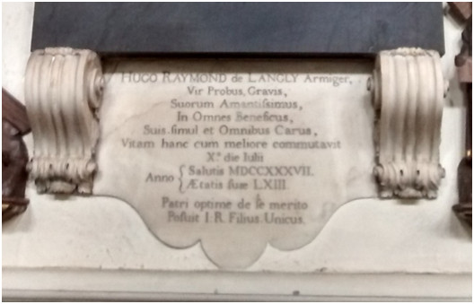
1739 - The Foundling Hospital: After 17 years of tireless campaigning, Thomas Coram finally received a Royal Charter from George II enabling him to establish his Foundling Hospital. Peter Collinson is one of the supporters of the Hospital established to address the problems of orphans, abandoned children, poverty and infant mortality. This was no immediate solution to problems but eventually led to improvements. As an illustration of living conditions in the 18th century, and even the 16th and 19th, it is enlightening. No direct link to the park but there was a small workhouse in Beckenham for the locally impoverished. For a long period people were associated with the Parish of their birth and if found in poverty in another parish were returned to their 'home' parish for poor relief. Some court records show rehabilitation orders for removal of people to home parishes. I recommend "London Life in the 18th Century" by M.Dorothy George if you can get a copy for a description of poverty, working conditions, housing and mortality.
1741 – Lancelot Tolson Tilly (LTT) dies. He had inherited Foxgrove among the estates of his uncle Lancelot Tolson who had no other heirs. LTT dies young and in his will he leaves his estates to his parents Joseph and Mary Tilly it seems because he is not expecting a long life and in the will he states that he has not acquired estates in Banstead from his father in law Gabriel Bestman in accordance with his marriage agreement and hence does not leave estates to his wife Elizabeth Tilly nee Bestman. However Joseph Tilly dies the same year and Mary Tilly also dies not long after, see his mother’s will of 1743 and his wifes will of 1748 by which process the estates appear to descend to Joseph Groves, Deborah Timewell (nee Bridges) and brothers John and Edward Bridges. The relevance is that Cator acquires a lot of these estates in later purchases and exchanges which in turn he exchanges some of with the Burrells.
1742 – Henry St. John, 1st Viscount St. John dies, the Manor of Beckenham is inherited by Henry, 2nd Viscount St. John, 1st Viscount Bolingbroke (ennobled with that title in 1712). See Wikipedia and History of Parliament online for more information on the St. Johns/Bolingbrokes. The family seat was in Wiltshire. Their estates were also in Battersea where there was a residence. There is no evidence of them occupying Beckenham Manor as a home and maybe they were absentee landlords although their land in Penge was in the Parish of Battersea. Some St. Johns are buried in St Mary’s Church, Battersea indicating that the residence was some distance from Beckenham Manor.
Henry 2nd Viscount St. John, 1st Viscount Bolingbroke
1743 – This passage explains how
some land became part of the
park or was part of exchanges to extend the park:
27 Aug: Mary Tilly nee Tolson dies, niece of John
Tolson 1670-1713 Gent of Staples Inn London though from Bekesbourne
Kent (and Lancelot Tolson his brother of Plaistow, Bromley), widow of
Joseph Tilly and in
her will Foxgrove land in Bromley, Beckenham and Lewisham that was
held in the Tolson family since 1712/16 becomes divided as she leaves
Stone
Farm and Plaistow to her widowed daughter in law Elizabeth Tilly (see
1748). She
leaves Foxgrove Farm and woodlands in Bromley, Beckenham and Lewisham
to Deborah Timewell a kinswoman married to Edward Timewell of Chigwell,
Essex, but the conditions of the Will state that if Deborah dies
without issue (which she did in 1752) then the property goes to her
brothers John and Edward Bridges, other kinsmen. The link to the
Bridges family is via Sir John Roberts of Bekesbourne, Kent who had
four or five daughters one of whom married into the Bridges and another
into the Tolsons. Another bequest of a farm at Wadhurst goes to
Nathaniel Tilly of Shepton Mallet, Somerset. As the Bridges brothers
inherit Deborah did not have surviving children. The brothers later
sell their parts of Foxgrove to Jones Raymond.
Also, in this year 27/7/1743 presumably before her death Mary Tilly grants the following lease: Originally part of Foxgrove: 14 yr lease from Michaelmas 1743 Mary Tilly to St John Humphrey woodlands named Lewisham Land Wood, Barnfield Wood, Clayhill Wood, Cold Shaws Wood, Bushey Picketts, Bushey Acres, Crooch Oat Shaws, Southerlands Woods, Tootswood, Kingswood, Bromley Wood, The Willows, two pieces Morris Wood – 200a late occ Lancelot Tolson Tilly. (Bromley ref 728/1/3)
St.John Humphrey is shown as a landowner on the various maps, possibly related to the St.Johns by some previous marriage.
The two Morris Wood and Lewisham Lands are on the Foxgrove maps and shown as Morrisswood East and West and Lewisham Lands which is now Summerhouse Wood. Rocque calls the whole area Langstead Wood on his map but I now question his source of information as Langstead Lane on his map is shown as Lagg Street Lane on the Foxgrove map of 1766.
The three pieces of land along with the rest mentioned in the lease come into the possession of John Cator. Barnfield Wood, Bushey Picketts, Bushey Ten Acres are in his exchange with Jones Raymond and Peter Burrell in 1759/60.
When the lease expires in 1757 it matches a time when Cator is acquiring land in Beckenham.
1745 - Rocque's Map is published showing about 10 miles around London including the park area. Note the houses or farms on Stoms Hill which would predate the Mansion. Some buildings on Stumps or Stoms Hill make us curious about any pre-existing buildings. Certainly there was a house or farm near the Mansion which is illustrated on the Road Diversion plan, of which more later. The detail in Rocque's Map and some of the names are perhaps questionable. Rocque has Stoms instead of Stumps Hill and Langstead Wood is called Morrisswood or Lewisham Lands on estate plans. Rocque’s use of the name Stoms Hill reminds me of the Stomeshulle name in the 1334 taxation list? Also the road should run more north/south than it does east west on his map which might be regarded as schematic rather than accurate? As he was mapping all of London and its surroundings some short cuts and errors are likely. See the comparison with the Andrews and Drury map of 1769 later on which shows Cator’s house on the site of the buildings indicated in this Rocque map. The will of Izarde Curtys of 1590 refers to his property at Stumpeshill so occupation and buildings predating the current mansion is most likely. If we take Rocque’s map and the Drury map as reasonably accurate then perhaps earlier building remains are under the mansion forecourt and on the opposite side of the drive through the park.
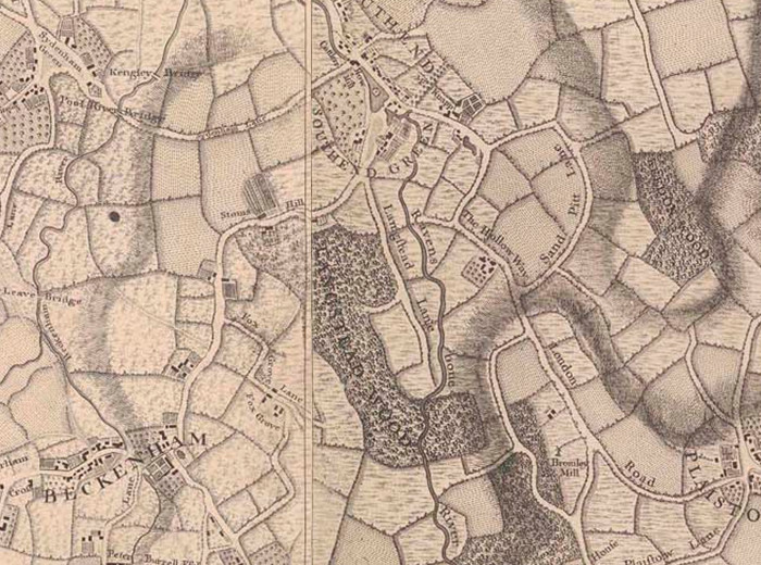
I’m sticking my neck out a bit here but the buildings between Stoms and Hill are the site of the Mansion, supported by the evidence of the Andrews, Drury and Herbert map later on in 1769. The small building just to the right of “Stoms Hill” could be the Home Farm. The buildings just above and left of Fox could be the Farm shown on the 1785 road diversion plan. Southend Road and Beckenham Hill do not exist at this time, the road shown is now the drive through the park.
John Cator’s brother Samuel is born, he will perhaps be the least fortunate of the Cator brothers. Although intended to takeover the family timber business he decides on a different course for his life.
1748
– Elizabeth
Tilly nee Bestman dies, she had inherited part of Foxgrove Manor (Stone
Farm and Plaistow) from her mother in law Mary Tilly. Her uncle Joseph
Groves inherits Stone Farm and the land at Plaistow from her. Elizabeth
was Lancelot Tolson Tilly’s widow. Foxgrove Farm and woodland was left to Deborah Bridges (married
to Timewell)
by Lancelot Tolson Tilly’s mother Mary Tilly nee Tolson. If Deborah died without issue then
John and Edward Bridges
should inherit. See earlier entries for the
procession of land ownership from Leigh to Tolson to Tolson Tilly and
to Groves. All the result of no direct heirs to leave property to
either
through no issue or early death hence the property of Foxgrove Manor
becomes divided between more distant kin. Groves already owned substantial
other property as do the other beneficiaries of the Foxgrove bequests.
1748 - The Cator timber business recorded as John Cator and Son at Mouldstrand Wharf, Bankside, Southwark. (source: Pat Manning). It may be of some interest to know what became of the timber business of the father in law, Brough of Westminster. Did both businesses continue or did Brough’s become John’s via any means. I find a John Brough occupation Sawyer married at Ratcliffe Stepney, and residing in Lambeth, dying in 1732
1749 - Peter Collinson moves from his house in Peckham to Ridgeway House, Mill Hill. Though seemingly a long way from Cator's home at Southwark it must be remembered that Collinson had a business in Gracechurch Street, London and both families probably met at Quaker gatherings. The Meeting House in Long Lane, Southwark is a likely venue although Devonshire House in Bishopsgate is another possibility as it was the venue for John Cator and Mary Collinson’s wedding. Whether any association had formed by this time is unknown. The subsequent marriage of Collinson’s daughter to Cator identifies Collinson as of Gracechurch Street so it seems he resides at both Mill Hill and Gracechurch Street much in the same way as Cator comes to reside at Beckenham and Southwark and later the Adelphi on the Strand. Collinson’s gardens at both Peckham and Mill Hill gain a reputation much respected in horticultural and botanical circles. He supplies plants to several high ranking people and is associated with Joseph Banks and Solander who accompany Captain Cook on his round the world voyage.
1749 (or 1751?) - Frederick, 3rd Viscount St. John, inherits the Manor of Beckenham and and the title Viscount St. John from his father John St. John. The title Viscount Bolingbroke is inherited from his uncle Henry in 1751 with estates in Battersea. There is perhaps some confusion to be clarified here as Hasted’s account is meandering and earlier maps of 1736 show John St. John as landlord of at least parts of Beckenham Manor. Many aristocrats had more than one title and sometimes changed names when intermarrying or inheriting estates. This can add some confusion to tracing events. Although it seems Bolingbroke did not own much land which is now in the park apart from a couple of plots, his sale of the extensive Beckenham Manor lands to Cator did allow Cator to become 'Lord of the Manor' after 1773, but without any title other than Esquire.
Frederick 3rd Viscount St.John, 2nd Viscount
Bolingbroke
1751 - Death of Henry St. John, 2nd Viscount St. John, 1st Viscount Bolingbroke. His titles will pass to Frederick St. John.
1753
- John Cator the younger of Southwark marries Mary Collinson, daughter
of Peter Collinson FRS, merchant and botanist on the 30th
August. The ceremony takes place at
The Quaker Meeting House, Devonshire House, Bishopsgate, London, it is
recorded in Quaker marriage records. The guests and family members are
listed on the document which is viewable in Ancestry.co.uk. The
marriage settlement document is in Surrey Archive whose catalogue
states that no property is mentioned in the settlement. There is more
about John and Mary in the ‘Additional Information’ separate
publication/file although apart from some passing remarks not much is
said or known about Mary. Hester Thrale later records ‘Mr Cator, his
wife and a niece, Miss Collison (sic)’ visiting her at Streatham.
Collison is a variation of the spelling of Collinson and this would be
Mary’s brother’s daughter. Although Hester Thrale and others record
some conversations with John Cator nothing is recorded by way of
conversation with Mary Cator. Whether this indicates a shy or quiet
disposition or maybe snobbery on the part of Hester Thrale and others
is to be pondered upon.
1753 – John Cator’s youngest brother William is born. “This is to certify the birth of William Cator son of John Cator (the Elder) was registered in the books of Horsley Down Meeting, London, the 18th day of the first month called January 1753” and is dated October 26th 1770.” There is reference to a William Cator as Cornet ensign 2nd Lt August 2 1769, who resigned April 3 1772, Madras in the book of Officers in the Indian Army by Dodwell and Miles. (source: Pat Manning). William will later make some fortune with the East India Company, become an owner or partner in a brewery business but , try to return to India with the East India Company when his brewery business fails but he is killed by French privateers near Calcutta. (some source material in Westminster archive and a Will with Canterbury Prerogative Court).
1756
- Peter Burrell I of Langley (1692-1756) dies and properties are
inherited by his widow Mrs. Amy Burrell. This may include some of the
parts of Foxgrove Manor which are now in the park but they seem to come
to her later via her brother Jones Raymond. Also his son Peter Burrell
II of Langley Park inherits other properties, this needs clarification
as estate plans show properties in the names of both Peter Burrell (II)
and his mother Mrs Amy Burrell. Peter Burrell I had been Sheriff, Kent
1732-3; director, South Sea Co. 1724-33, sub-governor 1736- d.; director R. Exchange Ass. 1726-38.
His position with the South Sea Company was after the Bubble affair and
after his marriage to Amy Raymond which may have enabled his entry into
the company through Hugh Raymond.
Peter Burrell’s
Will mentions his properties at Beckenham and a house at Covent Garden.
1757
- John Cator buys lands at Southend (source P.Manning from records at
Kent Archive).
"The property of Francis Valentine whose ownership was demonstrated by
the inclusion of a family tree. John Cator paid £1000 on 25th November
1757 for a messuage, outbuildings, yard, garden and several pieces of
land at Southend, Lewisham."
Subsequent research into the Valentine family tree, wills and property reveals that Francis Valentine the elder d.1736 had extensive properties including The Bell in Bromley, The Kings Arms at Farnborough and a Red Lion at Southend. (The Red Lion disappeared or got renamed) One of his grandchildren inherited the Green Man at Southend and whether the Red Lion changed name is an interesting question. Cator exchanges the Green Man with the Forsters of Southend later in 1794 but this purchase from Francis Valentine the younger could be any of the land around Southend Green as it was then called, which was left to the sons and daughters of Francis Valentine the elder.
It now seems unlikely that this is the Stumps Hill land on which the house is built but it is the earliest record of John Cator and Southend. Moving records onto databases might not have the same detail as old card indexes and we cannot find the record at |Kent Archive online. It might be part of ‘Manorial deeds’ records at Kent Archive. However £1000 at that time seems a lot of money unless it was for a substantial amount of land i.e. “several pieces”. Certain areas not covered by the Foxgrove or Beckenham Manor plans might have been part of this purchase. As Cator was acquiring land in several divers places and many landlords had widespread disconnected plots under their ownership several scenarios are possible.
What we do find later in 1794/95 is that John Cator seems to be the landlord (owner not publican) of the Green Man at Southend and a bakers and some cottages. See 1794/95 for more detail. He exchanges these with John Forster for a Mill and other property. Cator estate maps of 1833 and 1869 show land at Southend as part of the estate but not necessarily ‘emparked’. The term ‘emparked’ indicates added to parkland and probably fenced off from general access.
1757 - Frederick Viscount Bolingbroke marries Lady Diana Spencer, daughter of the Duke of Marlborough. The marriage is accompanied by a complex marriage agreement assigning trustees to Bolingbroke’s estates and guaranteeing Diana an income from the estates. From my cursory delving into the reports of subsequent court cases it would take a law professional to come up with an understandable summary of the subsequent events. See 1773 Cator’s purchase of the Manor of Beckenham. And the dissolution of Bolingbroke’s marriage to Diana Spencer
Lady
Diana Spencer, later Diana Beauclerk
when remarried after her divorce from Bolingbroke in 1768.
Also
in 1757 - Viscount Bolingbroke exchanges the Beckenham 'Old' Manor
House and grounds opposite St. George's Church for Woolsey’s Farm at
Clay Hill with Peter Burrell II of Langley, the son of Peter (I of
Langley) and Amy Burrell. As
Peter Burrell I had died the previous year perhaps Woolsey’s Farm was a
legacy and the manor house was seen as an attractive exchange? I
haven’t found any record of any Bolingbroke’s residing in Beckenham,
being more of an absentee landlord, and the house may have been
becoming a liability for maintenance or not fetching any income whereas
a farm would bring rents? The
Burrell’s did spend at least some time in Beckenham with various
members occupying Kelsey, Langley, Houses in the village and were
buried in
the Church or churchyard.
Bromley Historic Collections archive has this record:
1/2 August 1757 Lease and release and exchange of property between Right Honourable Frederick Lord Viscount Bolingbroke, Baron of Lydiard Cregote (should read Tregose?), Wiltshire and Viscount St John Baron Battersea of Surrey (1st part) and Peter Burrell of Beckenham, Kent, esquire.
The first parties (one person with several titles) assign the mansion house known as the Manor House at Beckenham, Kent with 8 acres of land to Burrell, in exchange for a messuage called Woolsey's Farm and lands and woodland in Beckenham. (Bromley Historic Collections). Roughly 65.5 acres. Burrell got Mansion 8acres, Great & Little Downs 17a abutting to the north Beckenham to Bromley Road, to the south Peter Burrells Garden, west a meadow called Court Mead and east Stone Field occ Peter Burrell. Also Court Mead 12a occ Peter Burrell including a capital messuage. Great and Little Downs may be what are both labelled Court Downs on the Beckenham Manor 1768 plan.
So the subsequent purchase of Beckenham Manor land and ‘Lordship’ in 1773 by Cator, excludes the manor house site opposite St. George's Church. This is probably the driving force for transforming Stumps Hill into Beckenham Place for Cator as ‘Lord of the Manor’.
The Cator estate plan of 1864 excludes the Old Manor house site and any land south of Beckenham High Street and Bromley Road. By 1809 The Old Manor house becomes the property of Henry Hoare before the Burrell estates in Beckenham are sold in 1820.
Woolseys Farm was at Clay Hill near Shortlands, I estimate it to have been where Downs Bridge Road runs from Albemarle Road to Bromley Road. It is on an estate map of 1723 in the British Library. The map states it is in the occupation of H. Fox though difficult to read because of the condition of the map. We latterly think it is the site of Shortlands House, now Bishop Challoners School.
1757-1765? – This is a complex time of land purchases and exchanges. About this time or as part of the 1760 Act of Parliament Cator may have acquired parts of Foxgrove Manor. W.H.Ireland states “It (Foxgrove) passed through several hands and became divided in three parts, the woodlands and store farm were purchased by John Cator”. This most likely is the manner in which Cator acquired the plots on the Foxgrove Manor plan of 1766. Margaret Mitchell suggests ‘store farm’ may be a misspelling of ‘Stone Farm’ which we know Cator had possession of about this time, adjacent to the Kelsey estate. That is confirmed by Hasted’s earlier account which Ireland misreads or is a printing error. As a point of interest Stone Farm appears to have been relocated sometime between the 1766 Foxgrove plan and the 1868 surveyed OS map. It seems the Burrells having acquired the earlier farm from Cator demolished it to extend their grounds at Kelsey and moved it to the corner which is now opposite the Chinese Garage and is a parade of shops.
We now know that Mary Tilly’s lease to St.John Humphrey in 1743 expires in 1757 and this looks like it prompts her heirs to sell Barnfield Wood, Bushey Piggot and Bushey Ten Acres to Cator which he exchanges with the Burrells. Also it looks like he purchases Morrisses Wood East and West along with Lewisham Lands woodland shown on the 1766 Foxgrove map as being within the area of what would later be the Park.
Hasted’s entry for Foxgrove explains that Foxgrove Manor was divided thus:This has errors but in essence Foxgrove was divided. Lancelot Tolson Tilly died before his wife and his parents. He left estates he had inherited from his uncle Lancelot Tolson to his parents Joseph and Mary Tilly. His mother Mary Tilly nee Tolson outlived his father and she left the estates in several parts. For our purposes the mother, Mary Tilly nee Tolson divided the estates, see 1743.
But then Hasted confuses the death of Peter Burrell with Jones Raymond and surmises that Jones Raymond had a son also named Jones which is not the case. However, this may be the point at which ‘the woodland’ becomes Cator’s Stumps Hill property and he acquires Stone Farm as well in 1761 from Joseph Grove who had inherited from Elizabeth Tilly.
We might assume that the Foxgrove Manor map of 1766 which shows lists of fields in the ownership of Jones Raymon is the result of the purchase from the Bridges/Brydges brothers of Wooton, Kent. Hence it shows land held by Cator and Bolingbroke from Cators earlier purchase from Joseph Grove or exchanges with Raymond and Burrell in 1759/60.
1759-60 – A Parliamentary Private Act from the Parliament archive online catalogue
http://www.portcullis.parliament.uk. John Cator exchanges lands in Beckenham and Lewisham with Jones Raymond and Peter Burrell II (1724-1775). This may include the land on which the mansion stands at Stumps Hill but needs more research or evidence to come to light, However, the transcript of the Act made by Mother Mary Baptist (1967) throws some light on it.
"An Act for exchanging certain Messuages, Lands and Hereditaments, in the Parishes of Beckingham (sic) and Lewisham, in the County of Kent, Part of the Estate late of Hugh Raymond Esquire, deceased, for other Lands and Hereditaments in the said Parish of Beckingham, belonging to John Cator the younger, and for settling the Lands so taken in Exchange to the same Uses, as the Lands given in Exchange stand limited, and for enabling Jones Raymond and Peter Burrell Esquires, to grant Building Leases of other Parts of the Estate, late of the said Hugh Raymond."
Essentially the Act states that the properties of Jones Raymond, Peter Burrell and John Cator are so intermixed so as ‘to render the possession and enjoyment of the properties inconvenient’ and the other interested parties consent to the exchanges.
This evidences that John had considerable land holdings already by the age of 31 and whether ‘hereditaments’ means he inherited some of it remains a question or is just a catch-all legal phrase. But the text of the act refers to John’s “Estate and inheritance” of land. The mention of Lewisham here draws attention to the fact that the land is on both sides of the Parish boundary. The map in the British Library attributed to 1780 shows some of these lands in the Langley and Kelsey area ie. called Barnfield Wood, Bushey Pigott and Bushey Ten Acres which can be traced on the map. Another map copied from a 1735 version has emerged from Kent Archive showing Bushey Ten Acres and Barnfield Wood. Cator transfers to Raymond and Burrell; Several woods or wood grounds in Beckenham called Barnfield Wood, Bushey Piggott and Bushey Ten Acres. Barnfield Wood Road now runs alongside Langley Park Golf Club.
John Cator acquires Lower field, Middle, Upper and Pond field, Barne Field and Orchard field. Let to Thomas Watford. Staceys with yards gardens and appurtenances and three fields called the Delvins and peartree barn and mill field in occupation of Thomas Selby. These can mostly be identified from maps as being around the Langley area but Delvins may be fields shown on the Beckenham Manor map as being the Delves which are bounded by the name Sir Francis Leigh which is a hangover from when Foxgrove was held by the Leigh family. And on the Foxgrove maps shown as Cator with Ld. Bolingbroke either side. That tempts me to believe the site of mansion was among these fields. The description of fields like upper, middle, lower, barn and pond are so common for different parts of estates that a definitive identification is difficult. Stacy's or Stacey's was at Pickhurst Green identified on a Jones Raymond/Langley Place map circa 1750 (undated but after Hugh Raymond's death and before the 1759 exchange)
Of direct interest here is that property within the boundaries of the now public park were acquired from Jones Raymond and the Burrells.
More can be said about the 1759/60 Act thanks to the writings of Mother Mary Baptist (formerly Bessie Taylor) of Coloma College, West Wickham. As part of a thesis in 1967 she copied out large tracts of this Act and the later one of 1825. From her records we can get a better idea of the extent of the Cator properties and the intentions of the Acts. I have to admire her fortitude in hand copying the detail from what is probably a difficult to read handwritten 18th century document.
It would appear that the Will of Hugh Raymond having left bequests to persons beside his direct heir Jones Raymond and directing how the estate should be preserved required an Act of Parliament to permit exchanges of property with Cator. A similar process would be required later by the heirs of John Cator in 1825.
Frustratingly we cannot absolutely identify where all these plots were, but can guess at some which must be on the 1766 Foxgrove Manor plan in Cator’s name and most likely include the site of the mansion. Whether it is either of the: messuage let to Thomas Watford is a tantalizing conundrum. Stacy's is found to be next to Pickhurst Green. However, the 1785 road diversion plan shows fields enclosed by the old road through the park and the new road which becomes Southend Road and Beckenham Hill Road. If we note the orientation of the map to point north then three fields could be Upper, Middle and Lower, there is the ancient pond in Pond Field, Barne and Orchard fields could be around the buildings which could be those let to Thomas Watford. If this is correct it would extend the property in Cator’s possession around his new house and date it to 1760.1760 – Viscount Bolingbroke petitions for a Private Act of Parliament to permit him to dispose of family estates in Kent and elsewhere. This will presumably later facilitate his sale of Beckenham Manor to Cator and Bolingbroke will sell Battersea estates to the Spencer family. Whether the same Spencer branch as his soon to be ex-wife Diana could be researched.
1760/62 - John’s father retires in 1760 and passes the business to him. At the same time Samuel Cator, John’s brother is taken into the business as a 7 year apprentice (source: Will of J.Cator the elder). Cator begins to build the house on Stumps Hill as recorded in the comment by Peter Collinson in his “Hortus Collinsonianus”. I’m inclined to believe the mansion site is on one of the plots exchanged with Jones Raymond in the 1759/60 Act of Parliament. Cator would have lived here and at Southwark. Considering his other property in the area its also possible he had other accommodation locally but no evidence has turned up.
1761
– Joseph Grove who had inherited Stone Farm in Beckenham and Plaistow
in Bromley from his niece Mary Tilly (see 1748) sells to John Cator:
meadow, pasture and woodland called The Stone Lands in 4 pieces, Half
Acres, Hawkesbrooks and East Decoy Croft.
At least some of these are near Kelsey and Langley but will form part of the lands Cator exchanges with the Burrells later in 1793. The Tolsons/Tillys were owners of Foxgrove Manor and other lands from about 1714. Cator pays £2400 for the purchase. From Bromley archive (researched by Keith Baldwin) Bromley Archive record has this: 23/12/1761 Joseph Grove of Richmond Surrey to John Cator £2400 meadow pasture & woodland called the Stone Land 4 pieces, Half Acres, Hawkesbrooks, East Decoy Croft, 2 pieces East Weblands, West Decoy Croft, 2 Bowling Green piesces or the Five Jurys, 3 called Bromley Lands & passage from Bromley Lands to Smithfield, 2 pieces called Smithfield, 2 called Great & Little Shortlands, Hop Garden, the droveway leading from Little Shortlands to May Hill, May Hill otherwise Malefield, Highfield, 2 called Wall Riddens certain pieces late in possession of St John Humphrey formerly Joseph King containing 9.3.5 and also woodland called Chaulks Wood total 160a estate of John Tilly to Lancelot Tolson Tilly to Joseph Tilly to Mary Tilly – Elizabeth Tolson Tilly to Elizabeth Tilly to Joseph Grove in occupation St John Humphrey but late Thomas Bassett.
Most of these sites can be identified on the 1780 ‘Burrell’ map from the British Library which shows plots in Cator's name. The effect of these purchases will be that Cator extends his estates and reorganises via later exchanges.
A question which arises is whether Cator had previously bought land from Grove which he exchanged with Raymond and Burrell a year or two earlier or had he inherited some land from his father John Cator the elder.
1762
– Peter Collinson records in a letter his visit to John's house newly
built on Stumps Hill. (maybe visiting his now pregnant daughter?).
It is now established that John Cator certainly came to live at the
house on Stumps Hill much earlier than 1773 as there are records of him
buying land in the area in 1757 and exchanging land with Peter Burrell
and Jones Raymond in 1759. John Cator's famous botanist father in law,
Peter Collinson speaks of his purchasing a fine estate and building a
house in letters dated 1761 and 1763. So we now know that the original
house dates to 1760-62 as the most recent revelation is a note by
Collinson in his Hortus Collinsonianus (catalogue of his plants) in
which he says:
"Sept. 17, 1762, went, for the first time, to visit my son-in-law, John Cater (who married my daughter), at his new-built house, now finished, at Stump's Hill, half way (on the south side of the road) between Southend and Beckenham, in Kent, began in the spring 1760, on a pretty wooded estate which he had then purchased. The plantations about it, all of his own doing, I found in a very thriving condition, and when grown up will adorn so stately a house, in so delectable a situation, and make it a Paradise. In his woods grows the native English Chesnut spontaneously. P. Collinson, F.R.S."
Then the publisher of this catalogue, Lambert says :When I visited these grounds, in 1812, I was much struck by the remarkably healthy appearance of many fine trees, including, as nearly as I can recollect, Cedars, Exotic Firs, Liriodendrons.
Though this map is part of the 1766 Foxgrove Manor estate plan, it seems to show a building above the 't' in “Cator's” near the top right of picture. Collinson’s comment about woods could refer to the other ‘Cator’ plots on the map and possibly the Morriss Wood East and West and Lewisham Lands sites as they are not listed as Jones Raymond’s. It’s also possible that Cator owns land north of the road if the 1757 purchase of a ‘messuage’ was the one on the Rocque map showing buildings either side of the road, or from the 1759 exchange with Raymond and Burrell. Some elements remain unconfirmed. Sweet Chestnut certainly grows in both of what are now called Stumpshill Wood and Summerhouse Wood.
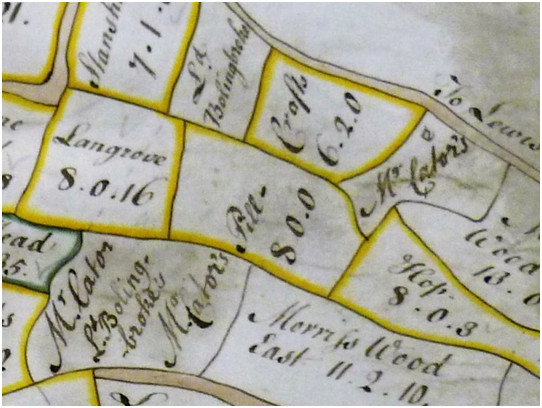
Courtesy of British Library©
The architect for the building has been a puzzle and remains so. An article in the Friends of BPP newsletter no.33 describes the ‘candidates’ for the design. It is reproduced in the Additional Information section of this history under “The House on Stumps Hill”. Briefly The ‘biggest’ name that gets a mention is Robert Adam. Other contenders are: George Gibson Jnr., who built St Mary’s Church in Ladywell and Stone House, 281 Lewisham Way, Loampit Vale opposite Lewisham College. Richard Jupp and most commonly suggested Robert Taylor who built Danson House (listed Grade 1), Danson Park, Bexley is not considered to have the same style as displayed in Beckenham Place. Although his name has come up several times in the past, he is no longer thought a serious contender. Henry Holland, who may have built Langley Farm. Holland in collaboration with his father-in-law ‘Capability’ Brown constructed Benham Park, Berkshire in 1775. The style does have many similar elements to Beckenham Place, but is this again because this style was prevalent at the time or did Holland oversee the work here, as his family did settle in this area?
To refer back to the land exchange of 1759/60 and “3 fields called Delvins”, the three plots in the map above with “Mr. Cator’s” may be those fields as the plot “Ld Bolingbroke’s” is annotated as Delves/Delvin on the Beckenham Manor plan. Bessie Taylor had much the same thought.
1762 - John Cator's father retires to Bromley (source: Pat Manning). It is said he had a house in Bromley and maybe some property as in his Will the following year he mentions rent from his houses and land left to his wife. Could it have been left to John the younger on his mother’s death or did John manage it among some of his exchanges? John certainly had some land in Bromley Beckenham borders and whether he purchased it all or inherited some has not been discovered. But now I’m wondering about the possibility that John the elder may have moved into property his son had purchased. Why? because in John Cator the elder’s Will below, he describes John Cator the younger as an astute businessman having improved his wealth and having ‘greater ability than I’. John Cator the Younger had taken over the timber business in 1760 and was left the business and the house on Bankside. The evidence of property to exchange in 1759/60 and the map attributed to 1780 but perhaps earlier show that John the younger had several properties that his Father and Mother could have moved into. No evidence has emerged of where John the elder resided though it may have been for a short time if he retired in 1760 unless he resided in Bromley while still running the timber business prior to 1760.
1762
- Edward Timewell dies, widower of Deborah Bridges. In his will he
leaves property to his brother in law Edward Bridges being some
inheritance from Mary Tilly via his wife. I am inclined to
believe that all the Foxgrove land had been disposed of to the Raymonds
and Cator, but some doubt remains expecially as the Foxgrove Manor map
has land outlined in a bold line being woodland left to Deborah
Bridges/Timewell.
1763 - A daughter Maria (also referred to as Mary) is born to John and Mary Cator. 1763 is also the year in which Cator’s father died and his mother is said to have come to stay with him but her later abode at the time of her death is recorded as Bromley. John the younger had been given the timber business and a house at Bankside back in 1760 when his father retired. His father’s Will settled in 1764 leaves substantial sums to his children i.e. £1500 to John’s brother Joseph who is in Jamaica at the time of the Will. John also gets the land owned in Ross, Herefordshire. John Cator the Elder’s Will mentions rents from his houses and land left to his wife which is another clue to the potential extent of John senior’s accumulated wealth. The will is witnessed by Richard Stapeles a farmer of Bromley and Thomas Staples his brother a tallow chandler. John junior is requested to act as father to the rest of the family and take his younger brother Samuel into the timber business as apprentice and then partner. Samuel’s death date has recently been found to be in Jamaica where he was employed as a customs official and the timber not pass on to him. Some historians have said Cator inherited considerable wealth but it seems that though he had ‘a leg up’ through the family business his net worth increased considerably during his lifetime. However, documents refer to John junior’s ‘hereditaments’ which implies he inherited some other property which might include some in his name on the 1780 Burrell map.
After John Cator the Elder's death his wife Mary Bough is baptized into the Church of England along with some of her children. As John Cator the younger and his brothers and subsequent members of the family are buried at St.George's it appears the whole family abandoned Quakerism or the Society of Friends.
The daughter Maria who dies in 1766 is buried in the tomb in St.George’s churchyard but John’s father’s burial is unknown but if he remained a Quaker it would have been in a Friends burial ground such as Long Lane, Southwark. Some sources on Ancestry.co.uk claim he died in Somerset, it remains a mystery.
This reference is interesting but not of great consequence to the history of the Park. “Found a skeleton in the Cator cupboard. Joseph Cator was married as a young man to Sarah Villers from Coventry but he ran off to Jamaica and left her in the lurch. This was from A2A on line by typing in Cator. Some solicitor’s papers were handed in to the Warwickshire Record Office concerning a bond taken out by John Cator of Bromley dated 1762 for £2,000 to guarantee that son Joseph would not claim against the executors of the will of Thomas Villers since Sarah Cator was a beneficiary. It is not a PCC (Prerogative Court of Canterbury) will and the Warwickshire Record Office is undergoing a refit at the moment but I should like to see the will!” (source: P.Manning)
1763 – In June Peter Collinson writes to John Bartram in America “Pray look, where grows nearest, some Azaleas, Kalmias, and Rhododendrons, for my son-in-law, who has lately bought a fine estate, and built a noble house, and made extensive plantations, and is quite cracked after plants, has plundered my garden all he can, and looks with such a longing eye on what remains, that unless thou sends me a box of those plants to keep all quiet—for my own son is so ardent to keep what I have—that I shall have something to do to manage my two sons. They are so fond of plants, and take such care in planting in proper soil and situation, it gives me entertainment to see their ingenuity and emulation. But my son CATOR deserves encouragement; for when he married my daughter, about ten years agone, he scarcely knew an apple tree from an oak ; but by seeing often my garden, and conversing with me and his brother, is now resolved, if he can, to rival us. In his new, fresh soil, plants thrive finely. I wish thou may pick out what I mean : being much engaged, can add no more, but that I am thy sincere friend, P. Collinson.”
This is perhaps an indication as to why Cator was protective of his estate in his Last Will and Testament although as far as I can make out his land at Stumps Hill may only have been as little as about 40 acres in 1763.
This example of a land exchange outside of the Beckenham Place area, next to Kelseys, between Cator and Burrell illustrates how property deals were conducted..... 25/26 March 1763 Lease and release of a piece of land called Stone Mead in Beckenham, Kent, containing one acre and two rood from John Cator the younger of Southwark, Surrey, merchant to Peter Burrell of Beckenham, esquire in exchange for land called Gatton's Mead, containing 2 1/2 acres in Beckenham. (Bromley Historic Collections). Lease and release was a means of exchanging property and avoiding tax and was later prohibited.
Stone Mead is found on the Foxgrove manor map adjacent to Kelseys and very close to the site of the lake in Kelsey Park, if not the actual site. This evidences that Cator had already acquired Stone Farm from Joseph Grove.
Gattons Mead is a small fields with 1.0.2 and 1.1.8 acres on the south side of Stone Farm. For clarification, land was measured in Acres, Roods and Perches. An acre is 4840square yards. There are 4 roods to the acre (1210 square yards) and 40 perches in a rood. Potential confusion can arise because a perch can also be called a pole or rod. But A.R.P is often seen on old estate plans and even some early maps or just shown as, for example, 4.2.6 as in the map above. I guess one can see that the 1.1.8 plot is approximately a quarter of the adjacent plot.
Below: Stones Farm with Gattons Mead shown to the left. Can this detail be used to date the ‘1780 Burrell Map’ to be closer to 1763? Stone Farm is referred to as Barnfield House under Cator’s ownership.
Image courtesy of British Library©
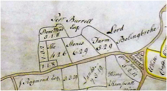
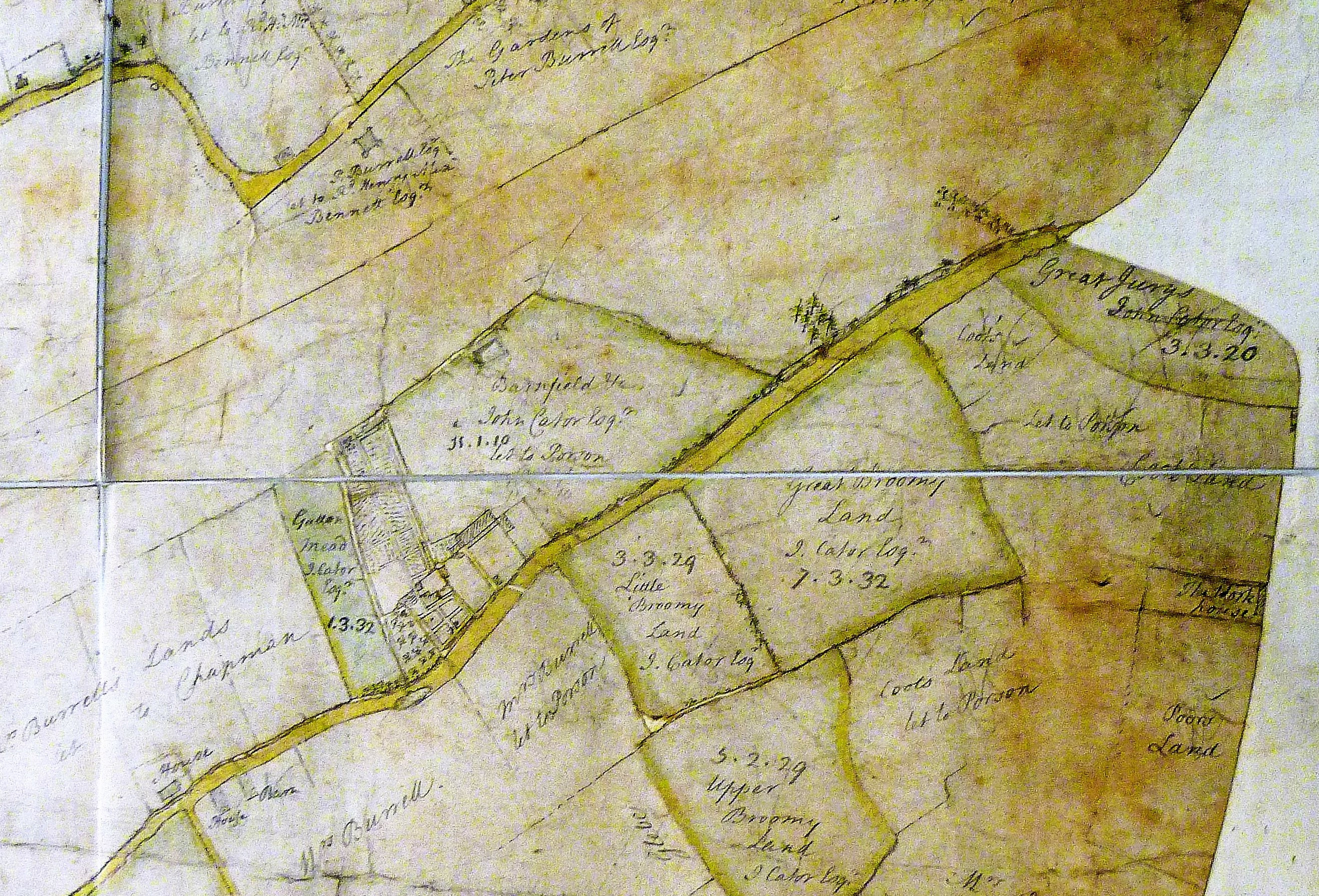
1764 – Joseph Grove dies, who had been left parts of Foxgrove estates at Plaistow, Bromley and Stone Farm etc in Beckenham via the Tolsons and Tillys which is believed to include Foxgrove Farm. He leaves the Plaistow part of Foxgrove estates to a nephew Groves Wheeler and in the will he mentions a mortgage “due to him from Mr. Cator at Christmas”. It is unclear what land the mortgage relates to but could be the land identified on the 1766 Foxgrove map including the Stone Farm mentioned under 1761. We may never know the full story but maybe this adds some substance to Cator’s activities in property dealing. John had exchanged part of Stone Farm with Peter Burrell a year earlier so had acquired Stone Farm from Grove a before that. Joseph describes Plaistow land as being under lease to Mr Davison who is seeking a longer lease of 100 years. The Plaistow land later becomes Plaistow Lodge.
1765 - Hasted states Foxgrove Manor was purchased by Jones Raymond from John and Edward Brydges of Wotton (should read Wootton/Kent) in 1765, but Raymond and Burrell were exchanging land with Cator in 1760 some of which is believed to be in Foxgrove manor so the date of 1765 is questionable. The Brydges were absentee landlords having inherited from a local relative but the Raymond’s appear to be ‘local’ landlords describing themselves as “of Langley” since their acquisition of that estate and having family members buried in the local church. More could be said about the Timewell and Brydges families which are intermarried, Deborah, Edward and John Bridges or Brydges are siblings and Deborah had married the Reverend Edward Timewell who outlived her, becoming owner of the woodlands, being her part of Foxgrove. The Tolsons are related to the Bridges by the marriages of two sisters of the Roberts family of Bekesbourne, Kent. The evidence that the park predates 1773 supports the likelihood that Hasted’s dates aren’t 100 percent reliable. Bearing in mind how difficult we find it to piece together events with the aid of the internet and modern means, Hasted’s task was even greater.
1765 – John Cator’s sister Mary marries Joseph Sparkes of Bromley. If not already then he will become a director of the East India Company thus strengthening the ties of the Cators to the EIC. Some time later a grandson of Joseph and Mary Sparkes will find a position in India as a judge. The Sparkes sons George and Henry are left bequests in Cators Will in 1806. It turns out that it is a complex facet of the Cator estates and Pat Mannings book addresses the Sparkes connection. See 1806 to 1825 timeslots.
1766 – John and Mary Cator’s daughter Maria dies in infancy. John's sister Ann also dies after a long illness (source: P.Manning). Many infant deaths were attributed to 'fever' but diseases such as measles, dyptheria, whooping cough, smallpox, scarlet fever, typhus, cholera, typhoid were all common, attributable to poor hygene, or not effectively treatable until well into the 19th century and beyond.
1766
– The Manor of Foxgrove estate plan is transcribed by Proudlove from a
1720 version. That earlier version has not surfaced...yet, which was
probably drawn up for the Tolson family. This updated transcription
shows plots owned by John Cator, Jones Raymond and Lord Bolingbroke.
The plan covers not only the area directly in and around the park but
some plots quite isolated in Elmers End, Kelsey, Langley and elsewhere.
It was drawn to indicate the Jones Raymond possessions hence the legend
of field names and acreages with other landowners indicated instead of
some field names.
Despite some unclear confusions of land transfers up to this point we may take it this reflects the situation in 1766 with no significant changes until after the 1776 version (see 1776). Also see 1777 where Cator exchanges other land for the fields named Pill Crofts here with Amy Burrell.
The land within the Foxgrove Manor which became the park was only the northernmost part but the more southerly part of Foxgrove Manor remained associated with Foxgrove Farm. Hasted and Ireland refer to the division of Foxgrove and Cator acquiring Stone Farm and woodlands. Whether the ‘woods’ may be Morisswood East and West, Lewisham Lands and/or the plots bounding the small ‘Bolingbroke’ section. Margaret Mitchell points out that ‘store farm’ in Irelands account is a misprint for ‘Stone Farm’ which is on the 1766 plan but adjacent to what is now Kelsey Park.
We know John Cator owned Stone Farm from the circa 1780 “Burrell” plan.
John Cator added some land to the park purchased from the Forsters and Francis Flower of Southend in Lewisham and probably the Earl of Rockingham who is identified on the Foxgrove Manor plan. The records of this area are more difficult to trace but the Rockinghams and Sondes family and Lees Court Estate possessed land at Mottingham, Lewisham and Bromley.
Estates were not always contiguous areas of land but very divers holdings often being the odd field, wood or farm. Intermarriage was one way these widespread estates accumulated. It seems John Cator acquired his early land acquisitions as they came on the market. The death of an estate holder might prompt the heir to sell some unwanted sites as we see later with John Cator’s heir, John Barwell Cator. The maps often raise as many questions as they answer.
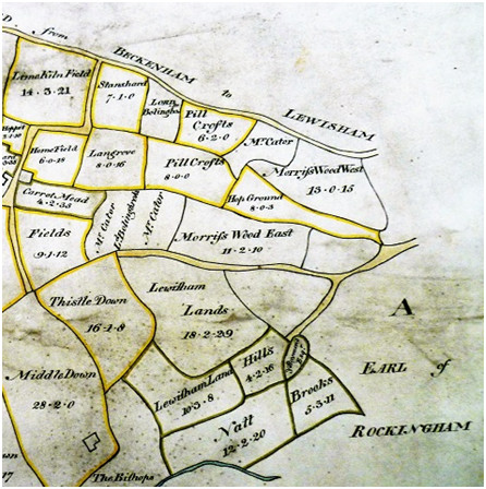
British
Library©
This
cropped image shows the area mainly within the Park. Mr Cator at the
top is the site of the mansion, The Lord Bolingbroke pieces are called
Hicks Field and Delves on the Beckenham Manor map, Thistle Down is now
called Crab Hill, Lewisham Lands is Summerhouse Wood, Lewisham Land
Hills is Railway Field and adjoining woodland, Natt and Brooks are The
Common by the river. Small parts of Earl of Rockingham may be on the
Common and backing onto properties in Brangbourne Road.
On the 1766 map Cator's land is surrounded by the holdings of Jones Raymond. The Hop Ground, Pill Crofts etc outlined by a dark line and yellow colouring are listed as Raymond's. It may be that plots not heavily outlined near Cator's are already his property. As the 1757 Southend purchase mentioned ‘several pieces of land’ and the 1759/60 Act named parts of Foxgrove Manor maybe Morrisswood East and West are Cators because they are not listed as belonging to Jones Raymond in the legend. I estimate the plots with Cator’s name plus Morrifswood East and West to be about 40 acres. But Cator’s plots are divided in any case because Jones Raymond owned Hop Ground (more research is needed). The Lord Bolingbroke annotation between two ''Cators'' plots is clarified on the Beckenham Manor plan as being a small plot owned by Bolingbroke but leased to someone else (Sir Francis Delves). So there was a jumble of ownership and occupation. Also few buildings are indicated on these plans so Rocque’s map is an indicator of where buildings may have been.
Some field shapes are recognizable to this day. Thistle Down is the modern day Crab Hill field and Lewisham Lands is most of the woodland (Summerhouse Wood). Lewisham Land Hills is Railway field and adjacent woodland. Natt Brooks is Summerhouse Field and the Common.
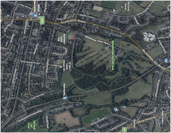
A bit more can be said about the Foxgrove Manor plan as it depicts lands owned by Jones Raymond. It also depicts lands owned by the Burrells and Lord Bolingbroke as well as Cator. Some fields are outlined yellow to show they are Jones Raymond's and a list at the side shows field names and acreages. Some plots are just named without an owner indicated i.e. Lewisham Lands 18.2.29 (18 acres 2 roods 29 perches). 2 plots called Morrisswood west and east bound the hop ground and may already be Cator's. The part annotated 'A' Earl of Rockingham is indicated as being grazed by oxen (12 great beasts of Foxgrove). This part is believed to have been a marshy area by the river probably no good for agriculture.
The road which is now the drive through the park is the boundary of the Foxgrove Manor and partly of the Beckenham Manor lands, but it seems some of the land along the western side of the road is not in either manor, possibly being Forster Estate/Lewisham Manor and Flower House property.
The description Lewisham Lands denotes land in Lewisham Parish which was or would be acquired by Cator. Lewisham Land Hills and Nat Brooks are owned by Jones Raymond as indicated in the legend below. The small lozenge shaped plot is believed to be a sandpit on the river floodplain. No buildings are drawn, only boundaries and enclosures. In my reading of the various maps it seems the line between Hop Ground and Morriss Wood East is the line of the stream in the park going back almost to Foxgrove Farm before it was straightened as part of the golf course landscape. It would make sense for a stream to be a boundary line. The Lord Bolingbroke plot by the church can be related to the Beckenham Manor plan (under 1768) as fields named the Pound, Church and Broom next to the church. Another plan of about 1780 of Burrell's holdings in Langley does show more 'habitation' as it was drawn for the purpose of recording leases and leaseholders. Some plans may have been drawn for marriage settlement or the Will of a landowner i.e. Jones Raymond dies 2 years after the 1766 plan. Or may be related to the sale of property or land tax assessment.
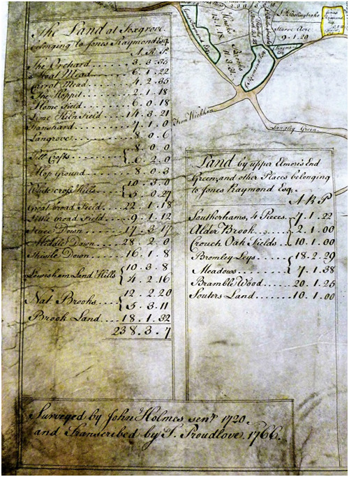
Images courtesy of British Library©
1768
- Jones Raymond of Langley dies with no issue or direct heir so his
possession of Foxgrove Manor is left to his sisters (Amy, Bridget and
Dynah) but seemingly the other sisters devise or sell their interest to
Amy Burrell who is Jones Raymond's widowed sister from her marriage to
Peter Burrell. Some lands appear in the name of Mrs Burrell or Peter
Burrell (II of Langley) on estate plans. The Burrell's already owned
other lands in Beckenham, Bromley and Penge such as Kelseys'. Jones
Raymond’s other property and Langley Park also passes to Amy and Peter
(II) Burrell. It was common for intermarriage between land owning
families. There were at least two marriages between other members of
the Burrells and Raymonds families. The Burrells had become 'of
Langley' rather than 'of Beckenham' or ‘Kelsey’ perhaps reflecting the
grandeur of the estate.
Jones Raymond's memorial plaque is in St. George's
Church is dated March
23rd 1768
The Raymonds and Burrells probably never lived in Foxgrove manor house which was more of a farm. The house was partially moated perhaps reflecting that it was an older more fortified property at one time, maybe a bit like Ightham Moat. In any case the house and moat are now lost forever. The Will of Jones Raymond in the Prerogative Court of Canterbury may prove interesting reading for those inclined to struggle through it. Mention is made of several of his relatives and their bequests.
The British Library have some documents from the East India Company with Jones Raymond’s name and signature. He was appointed a new director of the EIC in The Gentleman’s Magazine of April 1739. “A Voyage to the East Indies” John Henry Grose published 1766 states that Jones Raymond was still a named director of the EIC in 1755. And also later in 1757 in The London Chronicle.
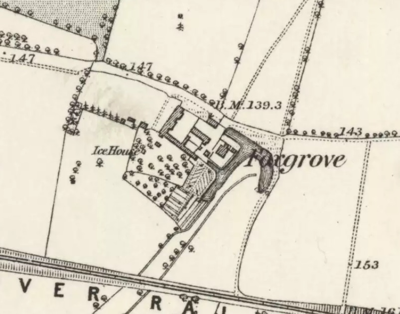
Foxgrove
farm/manor house 1865 OS map, note the Ice House
(from National Library of Scotland)
1768 - The Manor of Beckenham map or plan (below) is redrawn and transcribed by T. Proudlove from a 1623 plan. The plan is in The British Library. The two parts of Beckenham Manor had been reunited under the St. Johns (see 1623). With the Foxgrove Manor plan of 1776 below it it is possible to fit the Bolingbroke land next to the church with Church Field and Broom Field in the plan below and see how a piece of land is unaccounted for by both Manors. This plan raises a question as to why the Manor opposite the church is not annotated as belonging to Peter Burrell from the prior exchange in 1757.
The
date of the plan, 1768, matches the date that Frederick St. John sought
a divorce from his wife, Diana Spencer, daughter of the Duke of
Marlborough. Diana had been assigned Beckenham Manor land as part of
their marriage settlement and apparently the land returns to
Frederick's possession in return for a financial settlement with his
now ex-wife Diana who subsequently marries Topham Beauclerk.Viscount Bolingbroke and Diana Spencer are divorced by Act of
Parliament. The estate plan of Beckenham Manor may relate to the
separation settlement. Or as Bolingbroke reputedly had financial
problems he may have been considering a sale of the estate. It seems
Diana Spencer was awarded £800 per year from the estates of
Bolingbroke, a considerable sum at the time and different sources will
value it differently but £1 in 1750 may be equivalent to £180 to £240
today. So Ms. Spencer may have been receiving the equivalent of about
£1.4 to £2 million p.a. Bolingbroke had earlier in 1763 sold
Battersea parts of the St. John estates to the Spencer family.
This book available online has a good account of the divorce.
"Dr Johnson's Friend and Robert Adam's Client Topham Beauclerk". Some references describe Beauclerk as as much of a ‘cad’ as Bolingbroke, being an abusive husband with questionable cleanliness.
Reproduced by kind permission of the British Library © Shelfmark(s): Cartographic Items Maps 188.k.3.(4.)
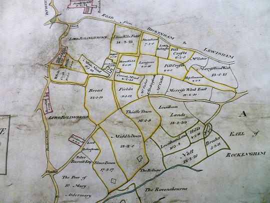
Reproduced
by kind permission of the British Library ©
On the above plan Beckenham Place would eventually occupy the bottom left corner outside of the Beckenham Manor boundary. The plan is orientated with North at the bottom and the road running down from the church is the road which runs through the park from approximately just above Hicks Field. Hicks Field, Sir Francis Leigh is written above Delves plot which is marked as Lord Bolingbroke’s on the Foxgrove plans as is Hicks Field. This is another example of the mixed ownerships and of how if a plot belonged to another landowner it was described as 'Lord Bolingbroke' or 'John Cator' and the field name omitted.
Sir Francis Leigh is indicated as a landowner of the areas not in Beckenham Manor but in Foxgrove Manor, but by 1768 The Leighs had sold this area to the Tolsons and it became divided as explained in earlier points on the timeline ie 1716 and they in turn divided and disposed of it to Jones Raymond, Lord Bolingbroke and John Cator. Although the ‘Bolingbroke’ parts may have already belonged them on the 1623 version if only it was in existence..
The only part of Beckenham Manor within Cator’s Beckenham Place may be the left edge of ‘The Lawn’ and ‘Spring Park’ which seem to be the curve of Stumps Hill Wood. Maybe the ancient oaks along the edge of Stumps Hill Wood are manor boundary markers. After Cator’s death much of that part was sold in the 19th century for building. A few large houses were built and possibly after wartime bomb damage some were demolished. The current Calverly Close estate occupies much of this section. The map extracts below show how the curved edge of woodland matches with ‘Spring Park’ and the bottom edge of Spring Park follows the old parish boundary between Beckenham and Lewisham Parishes.
1768 – Kent Archive has this record but unfortunately any
plans are missing. See 1780 map reference as the map perhaps should be
dated to circa 1768 as a draft line is on it for a road diversion.
Part
of highway leading from Beckenham to West
Wickham,
from north end of Langley Pond Mead Hedge in Beckenham, southwards
across avenue of capital messuage of Amy Burrell, widow, late of Jones
Raymond, Esq., called Langley House, and thence south-eastward towards
Langley Park, and thence south-westward between lands of Amy Burrell
called Red Lodge Farm to north-west
corner of Wickham
Green in West
Wickham,
295 rods [1,622 & 1/2 yards] long, 20 feet wide, to be diverted by
Amy Burrell to new line from the beginning of the old highway, through
Hawks Brooke Lane, thence westward towards farmhouse occupied by Job
Floyd near Langley House, thence southward, through fields of Amy
Burrell called Upper Ridleys, Walnuttree Field, James's Fields, Further
Field and Barn Field to Beckenham - West
Wickham
road
at wheeler's house and shop, occupied by Thomas Hewman, 304 rods [1,672
yards] long, 20 feet wide.
Part of footpath in Beckenham and West Wickham, leading westward from messuage of Amy Burrell in Beckenham called Brewhouse Farm, across the above highway and the avenue, thence southward, through Four Fields belonging to Red Lodge Farm, called Ockfield, Conduit Field, James's Field, and Orchard Field, and oat by a stile to the above old highway near Wickham Green, 260 rods [1,430 yards] long, 3 feet wide, to be diverted as above.
Below: Part of the “1780” perhaps showing the 1768 road diversion. The kink in the road across the avenue of trees is around Langley Place house and Cator has two fields adjacent to it. A letter from William Burrell to his brother Peter mentions their mother Amy Burrell complaining about the old road needing regular repair.
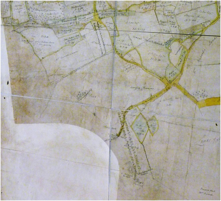
(courtesy of British Library©)
1768 – Is also the year in which John Cator first stands for parliament
at Gloucester but is defeated.
1769
- John Cator was certainly living at Beckenham Place in 1769 for his
house is clearly marked on a map published by Andrews, Drury &
Herbert in that year. He may well have come to live here soon after his
marriage in 1753 but now we know from Collinson that he certainly built
a house by 1762. Peter Collinson writes to Benjamin Franklin about
being on the eve of his daughters wedding 12th August 1753. John Cator
retained property at Bankside, Southwark near his business until 1794.
The Andrews map shows a building with a rounded bay at the rear as is
the construction of the mansion but no projecting portico at this time
nor a lake in the grounds. The scale prevents much detail being drawn
but the record of other landowners is interesting and a clue to further
investigations at various archives. The map does appear to be
inaccurate is some respects and also similar to the earlier Rocque map.
I guess the scale and accuracy are far below what was later achieved by
the Ordnance Survey.
The Rocque map is further below for comparison and as the road
alignment is almost the same on both maps 'it may be' that Rocque shows
buildings either side of the road on or near the site of the mansion
prior to the 1760/62 date of the building of the mansion. Investigation
of the land around and opposite the mansion, under the current car
park, might reveal some remains. Speculation probably based on these
maps has been that the mansion is on the site of a previous building or
is an alteration of it. If Cator bought an existing 'messuage' of
buildings and land he may either have demolished and rebuilt in a
fashionable design or altered the building. We may never know the full
story.
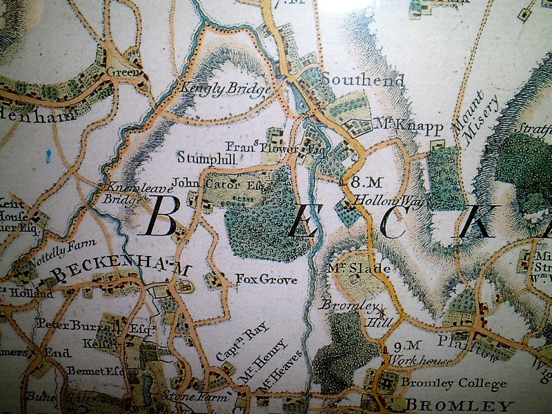
1769
Andrews and Drury
1745
Rocque
1769/70 – Viscount Bolingbroke leases the Manor of Beckenham to Mrs Margaret Hare which will present John Cator with difficulties later on when he ‘buys’ the estate in 1773 without Bolingbroke revealing his prior leasing of the estate. Some effect of this may impact the parts of Foxgrove Manor identified as belonging to Bolingbroke on the 1766 and 1776 plans. Mrs Hare pays Bolingbroke £3000 and expects rents in return of £500 per annum. Bolingbroke apparently makes one payment but then omits to pay further instalments. We used to call that ‘dodgy’.
1772/80 - John Cator is elected MP for Wallingford. This will be his longest period in the House of Commons (History of Parliament online)
1773 – John Cator purchases the Manor of Beckenham from Frederick St.John, Lord (Viscount) Bolingbroke who had inherited the estate and Bolingbroke title in 1749/51 from his uncle. The purchase price was £19,688 and Cator transfers South Sea annuities to that value to Bolingbroke’s and his trustees. Bolingbroke signs over the annuities or dividends from the South Sea Stock to a Mr. Boldero, maybe to pay off other debts?
This purchase of the Lordship of the Manor of Beckenham in 1773 from Lord Bolingbroke confused the date of John Cator coming to live in the area and the date of Beckenham Place for many years with many references still citing 1773 as the date of the building.
John’s house at Stumps Hill was adjacent to the Beckenham Manor lands and this may be the date when he decides to refer to his house as the mansion or Place since the old manor house in Beckenham was never in his ownership. I presume that from map evidence, that included in the sale, Bolingbroke land in Foxgrove Manor was also acquired by Cator. Bolingbroke also had property around Kelsey and Langley which it seems also came to Cator as part of the purchase and may have included land up to what is now Crystal Palace which is shown on the Beckenham Manor map of 1768. We have to compare the whole of the 1766 Foxgrove Manor plan which also covers Kelsey and Langley though in little detail, and the 1768 Beckenham Manor plan with the 1780 Burrell plan which shows a lot of property in the name of Cator which had been Bolingbroke’s.
It may be that Cator altered the Beckenham Place building at this date but no definitive evidence has emerged. Cator obviously occupied and had effective ownership of some of the land surrounding his home long before this and indeed did not acquire the Lordship of the Manor of Foxgrove until 1793 in a land rationalisation deal with his then neighbour Peter Burrell III (Lord Gwydyr 1754-1820). That is not to be confused with the Private Act recorded in parliamentary archives describes some land exchanges in 1759 with the Peter Burrell who was Lord Gwydyr's grandfather.
The purchase of land from Bolingbroke was less than straightforward as subsequent court cases in Chancery and Kings Bench demonstrate which involved the transfer of land and obligations to third parties i.e. Bolingbroke’s wife Diana Spencer had rights to income from the estate for her use. Mrs Margaret Hare had lien on part of the lands as Bolingbroke had leased the estate to her for £3000 on the basis he would rent it back for £500 per annum presumably so that he could raise some funds. However, he only paid her one years rent and defaulted on the rest. (see Internet searches). 'Hare' is shown as the owner of some fields on various estate plans outside of the park area. Another subsequent court case in 1780 was between one Goodright who was a lessee of Mrs Margaret Hare and Cator. Cator did not acquire full occupancy and control of Beckenham Manor until 1780. Presumably the problems with the occupation of the land did not affect Cator’s right to be called ‘Lord of the Manor’ but that is unclear. Bolingbroke's reason for selling the land seems to be related to the dissolution of his marriage to his wife Lady Diana and his financial problems from his dissolute lifestyle. He had a reputation for gambling and general excess. He also sold family estates in Battersea to the Spencer family around this time.
There are some similarities in the obligations of landowners in that the Wills of their forebears specify limitations on the disposal of property in that if land is sold it should be replaced by other property for the same uses. This is the motivation for the various Acts of Parliament to permit what are effectively changes to the terms of Wills. (This is my amateur view having looked at some of the court records and Acts).
Mrs Margaret Hare sues Cator for her right to rents from land. Cator sues some of the trustees ie Lord Pembroke. See 1780 and 1787 for some more information.
So when Cator bought the Beckenham Manor estate it seems not knowing that other parties had some 'lien' on either land or income from land as Bolingbroke did not reveal it to him. The details in case records are complex and in legal jargon but make some interesting reading. It seems the cases dragged on until about 1787 with Cator seeking recompense from Bolingbroke’s trustees. Perhaps a lawyer may offer us a simplified summary of the related cases concerning Mrs Hare, Boldero, Cator and Bolingbroke. In any case the various land transfers, purchases, and presumably management of the estates took up much of Cator's time.
The following is an extract from:
"Reports of Cases Argued and Determined in the High Court of Chancery ..., Volume 2"
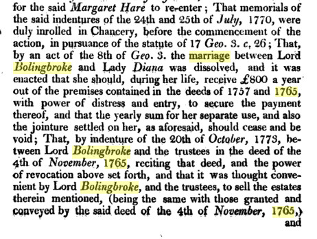
This extract from 'The Law Library - published 1841 indicates that Bolingbroke may have been fraudulant in the sale of the estate....
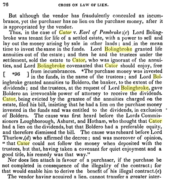
There is a certain irony here in that Bolingbroke was not censured or prosecuted for his deceit while petty felons were being transported or hanged for crimes involving much less monetary value.
1775 – Peter Burrell (III) dies, son of Amy Burrell she outlives him and the estates eventually pass to her grandson, yes, another Peter Burrell who will become Baron Gwydyr.
1775 – June, Mrs Thrale mentions Cator in a letter to Dr. Johnson. They apparently were on a river trip together in barges. Although this account is primarily about the evolution of Beckenham Place Park this is as good a place as any to put some anecdotes about Cator. Samuel Johnson described his as rough and manly, independent understanding and does not spoil it by complaisance. Hester Thrale marked very low on several social aspects but her husband appointed him joint executor of his will, guardian of his children and had several business and social associations with him.
Fanny Burney had little regard for him it seems, considering him to be an incessant talker on any subject and observing the following.
However, delving into the writings of Fanny Burney, Hester Thrale/Piozzi and even Samuel Johnson reveals a preoccupation with trivia and to me seems to show people with too much time on their hands, obsessed with social standing. Even so, we are left with only third party opinions of Cator who was by all accounts just doing what many of his contemporaries were doing then and is true today, guarding their own fortunes.
1776 – John Cator is recorded as being at number 5 John Street, a development of apartments near The Strand built by the Adam brothers on:
www.british-history.ac.uk/survey-london/vol18/pt2/pp131-137#h3-0007
From 1776 to 1782 and number 7 Adelphi Terrace from 1782 to 1806. He would have desired a town residence for his business and political career now that he was an MP. Other residents in the Adelphi were the Adam brothers themselves and Garrick the actor though Garrick died in 1779 at number 5 Adelphi Terrace his association with Cator is tenuous if not unlikely. Cator died there in 1806 and his apartment was left to his heir John Barwell Cator.
The Cator house at Bankside, Southwark was old by this time and perhaps not up to the standards which Cator was becoming used to. “The House by the Thames” by Gillian Tindall describes number 49 Bankside which the Cators occupied at one time. It was near the Mould Strand Wharf timber business. Possibly Cator was managing the timber business at arms length by this time.
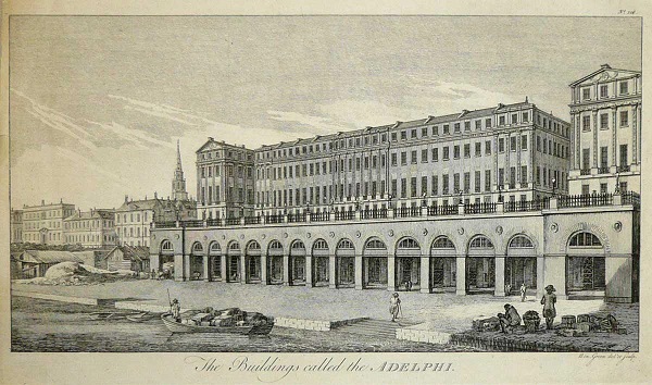
The Adelphi
1776 – The Foxgrove Manor plan is redrawn by John Sale from several plans (in British Library). It shows there was no change in Cator's holdings in the park area but does show he has acquired some land in Beckenham Village. The map under '1766' is this version but as said is easier to read. There is no legend describing Raymond or Burrell ownership but I believe the yellow outlined areas are still (Amy) Burrell property. Other plans of Langley Park of 1780 show his holdings were considerable but widespread from Bromley to Elmers End and West Wickham and intermingled with the Burrell's lands.
Although the fields annotated Ld Bolingbroke or Ld St.John are still named that way I believe they have passed to Cator with the Manor of Beckenham 1773 sale but maybe the outstanding court cases and lease to Margaret Hare are preventing the full transfer of property? One piece of evidence is the field named Lord Bolingbroke next to Pill Crofts which is identified as John Cator’s on the 1777 plan shown under ‘1777’.
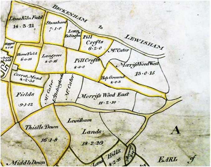
Courtesy of the British Library ©
1777 - In thie following estate plan of 1777 below, the plots called Pill Crofts and Hop Ground (or part of it) are belonging to Mrs. (Amy) Burrell so we might assume that Cator had Morrisswood east and west and maybe part of the hop ground. If these plans accompanied an exchange it demonstrates that Cator did not own all of the park area until 1777 or later. He is shown as owning land surrounding Mrs. Burrell's. Similarly a plan also of 1777 of some fields belonging to John Cator in the Langley Park area is made. Does this imply some exchange of land at this date as Cator and the Burrells reorganize their estates.
Then we have to ask how the 1793 exchanges between Cator and Burrell affected holdings or indeed whether any other exchanges took place of which we are not yet aware.
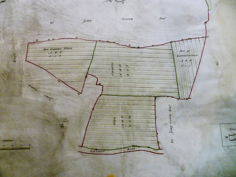
Reproduced by kind permission of the British Library © Shelfmark(s): Cartographic Items Maps 188.k.3.(3.)
Some of the field boundaries in these maps are still visible in the landscape on aerial photo maps such as Google Earth and Bing. The tree lined boundary is I believe the route of the stream and some trees may still be in the landscape, particularly one near the southern boundary of the park on the stream/ditch line. However, re-landscaping under the 2018 ‘restoration’ may destroy or bury such features.
The earlier map published by John Rocque in 1745 does not show the hop field, but depicts a continuous stretch of woodland called Langstead Wood stretching all the way to the Ravensbourne. The hop field may have been created between 1748 and 1766, but Rocque's map is not highly detailed being of a scale of about 1 inch to the mile. The two later maps of 1766 and 1776 are probably accurate as traces of the features depicted on them can still be seen on modern ordnance survey maps. By the time of this plan below of 1777 the Amy Burrell holding is surrounded almost by John Cator's land. The top boundary of Hop Garden, Pill Croft and part of Langrove Field is I believe the original course of the stream which supplied Cator's lake. The stream was later straightened and buried in a pipe perhaps to extend parts of the golf course.
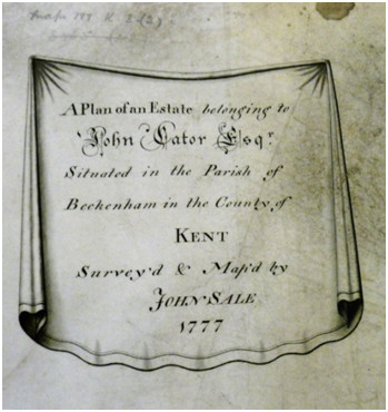
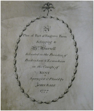
Title lozenges from the two estate
plans of 1777 (British Library©)
1778 – Edward Hasted publishes the first edition of his Topography and History of Kent (MDCCLXXVIII). Intriguingly in volume 1 of this edition has the Bayly's print of the Beckenham Place mansion and shows a lake. Whether the print is true to life is debatable. We thought the lake could not be installed until after Cator had the road from Southend to Clay Hill closed in 1785, whether he diverted the road or the lake was smaller so as not to cut the road is purely conjecture. There are differences between the two editions of Hasted, the latter one probably prompted by the publication of Lyson's Environs of London. Lyson's descriptions are shorter.
Hasted
first edition: https://books.google.co.uk/books?id=dKI0AQAAMAAJ&lpg=PA87&dq=hasted%20beckenham&pg=PA80-IA5#v=onepage&q=hasted%20beckenham&f=false
1778 – Cator proposes an amendment to the Insolvent Debtors Act in Parliament. The amendment appears to be in his own interests as it concerns persons indebted to him in his business affairs.
1778
- Hasted's first edition of his History and Topography of Kent is
published. It contains Bayly's print of the mansion. It shows a villa
with
views of a lake but no evidence of the portico which is constructed
with materials from Wricklemarsh at a later date. The print presents
some questions regarding the lake in the park. It was thought the lake
could not be constructed until the road from Southend to Clay Hill was
closed by Cator in 1785. The possibility exists that perhaps a smaller
lake was constructed between the two roads (see 1785 map) and extended
later. Map evidence also suggests the lake outline was changed between
1799 and probably1820ish.
If the portico had
been on the mansion at this time it would have protruded to the left of
this aspect. The
house originally had no attic dormer windows. The internal staircase
shows that the attic rooms were a later alteration, possibly mid to
late 19th century. As Cator had acquired Wricklemarsh in 1783 it's
possible that demolition material was brought to Beckenham Place to
clad the red brick building with portland stone by this time. The lack
of an image of the original house on Stumps Hill is frustrating.

Fanny
Burney writes a letter describing Mary Cator as a Mrs Nobody, but I
have little faith in Burney's characterisations. https://new.artsmia.org/stories/botanomania-and-the-secret-history-of-women-plant-collectors/
1780 – Regarding the Cator Coat of Arms, Pat Manning writes “The interest in this line (tracing Cator family history) lies in the fact that the brothers John and Joseph Cator used the William Cater arms to produce their own designs in about 1780, including that on the pediment of Beckenham Place. Their brother William also had arms engraved on silver plate such as a chased coffeepot held at Woodbastwick. * This may be no more than the widespread abuse of heraldry that was common in the 18th and 19th centuries. It was aided by the publication of works like Joseph Edmondson’s “Complete Heraldry” of 1780 in which is listed the arms of Cater recorded at the Visitation of Berkshire in 1566.”
1780 - A Map of the “Burrell” estates south of Beckenham, Kelsey to Langley Park area: In the British Library, part of which is missing, illustrates how Cator's and Burrell's possessions are very mixed. I suspect the map was divided as part of the 1793 exchanges with Burrell retaining this half as it relates to property they acquired and Cator obtaining the other half though the ‘other half’ hasn’t surfaced...yet. If the date is correct then Amy Burrell and her son Peter would be the Burrells anotated on the map.
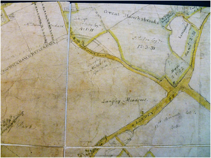
1780 part of an incomplete plan showing parts of Langley Park etc.,(British Library©)
British Library catalogue Title: [Part of a large map of estates belonging to Peter Burrell and to other members of his family in the parish of Beckenham, surveyed about 1780. Mutilated, wanting the title and scale and all the north-western and south eastern parts of the map]
Subjects:
BECKENHAM,
Kent (Parish) -- Estates - -- Maps and charts -- 1780
Publication Details: [1780?]
Identifier: System number 004801191
Physical Description: 1016 x 1350 mm.
Shelfmark(s): Cartographic Items Maps * 3065.(50.)
The Cator properties are extensive to the south of Beckenham village but the subsequent estate maps of the early 19th century show that the Burrells owned most land to the south of the village and the Cators the land mainly to the north following exchanges in 1793. Whether this plan forms the basis for land exchanges is not confirmed but it does give an insight into the complexity of property ownership. The question mark over the date of this map could mean it relates to 1777 plans and exchanges but that is unconfirmed. What is surprising is the amount of land Cator held very near Langley and Kelsey which Cator acquired from the Tolson/Tilly heirs and beneficiaries through purchases from Joseph Groves and Timewell or the Bridges.
The names of Burrell, Cator, Hare, Lethieulier can be identified as landowners or previous landowners and several leaseholders names are shown. The Cator lands will become subject to land exchanges. These plans are tantalising glimpses into the landowning situation.
This map has drafted outlines of road diversions and may relate to 1768 road diversions recorded at Kent Archive, see 1768. If so this may mean the map is earlier? The map raises several questions regarding ownership and names. What becomes Langley Farm is next to a field named Cuts Croft and surrounded by Cator and Lethieullier land. The Burrells diverted roads in stages, firstly a small diversion away from the house at Langley Place and subsequently putting a new road to the route of what is now South Eden Park Road.
Below, Stone Farm although called Barnfield House owned by John Cator, the site bounded by the neighbouring ‘Kelseys’ belonging to the Burrells. (British Library©)
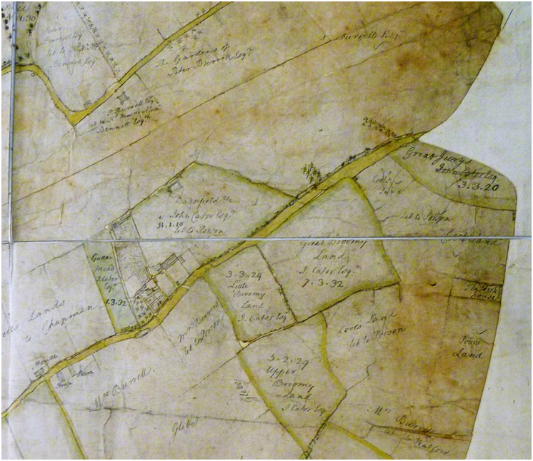

1779
- Related to Kelsey
Park and to illustrate land dealings. Counterpart lease for 60 years,
Surrey Archive 257/13/11
1) Peter
Burrell
2)
Richard Henry Alexander Bennet. Messuage called the Gattons and
messuage called the Flint House, and land, 150a, containing the Stone
field, the Downe field, Barn field, German field, Pidgeonhouse field,
Longlands, Little Longlands, Gattons, Temple Obelisk, Putlands, Two
Clampfields, Grove Lee, Grove and Crabtree Hillfield, and
appurtenances, excepting messuage called Kelseys while said Peter
Burrell or his mother shall live, timber and rights of way,
in Beckenham,
Kent.12
Oct 1779
1780
– John’s brother Joseph marries Diana Bertie in Calcutta. He is 47 and
John Barwell Cator is born the following year. There is some evidence
that Joseph had married a Sarah Villers in 1753 but it may have been a
different Joseph Cator. (recorded in clandestine marriages register for
Spittlefield) (Berties ancestry https://irp-cdn.multiscreensite.com/c3844fd3/files/uploaded/2001%20March.pdf)
Also in 1780 the court case is heard between John Cator and Mrs Margaret Hare concerning Cator’s right to the Manor of Beckenham. Bolingbroke and his trustees had sold the Manor to Cator without revealing that it had already been leased to Mrs Hare and others. Cator compensates Mrs Hare to retain his right to the estate. He later seeks recompense from Bolingbroke’s trustees. See 1787.
It may be, I suspect, that although Cator bought the Manor of Beckenham from Bolingbroke and it probably included Bolingbroke’s parts of Foxgrove Manor and elsewhere so that Cator did not have sole rights over the property until this year in which his compensation of Mrs Margaret Hare does give him full ownership.
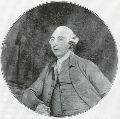
John Cator - Portrait by Joshua Reynolds
This portrait would have been in the round plaster border over the fireplace in the south facing room. It is supposed to be now at Woodbastwick in Norfolk. The plaster surround is approximately 36 inches diameter and the picture is described as about the same size in a catalogue of Reynolds paintings.
1781 - Carl von Linne the younger, the son of Carl Linnaeus, comes to London. There is no evidence to say whether this is the Linnaeus who might have met John Cator but as Carl junior did meet Joseph Banks, Solander and others who knew Peter Collinson then there is a potential link. Carl contracted an illness which killed him on his return to Sweden in 1783. It is recorded as jaundice. See Linnaean Society and Wikipedia entries. If this is the Carl von Linne who met Cator then its unlikely he had anything to do with estate planting as Cator had been at Stumps Hill for about 20 years.
1781 – 4th April, Henry Thrale dies, husband of Hester Thrale. The association of Cator with the Thrales is one of the few sources we have into Cator’s personality. Henry Thrale is listed on History of Parliament as MP for Southwark 1765-80 with some interesting detail of his life.
1782 – Cator is recorded as being at number 5 John Street from 1776 to 1782 and number 7 Adelphi Terrace from 1782 to 1806. He would have desired a town residence for his business and political career. Other residents in the Adelphi were the Adam brothers themselves and Garrick the actor though Garrick died in 1779 at number 5 Adelphi Terrace his association with Cator is tenuous if not unlikely. The Adam brothers had moved to Robert Street in 1778 and any connection with Cator is unknown though he may have been influenced by the fashion for their work. Cator died there in 1806 and his apartment was left to his heir John Barwell Cator who seem to have kept it as a town house for some time.
(source: www.british-history.ac.uk/survey-london/vol18/pt2/pp131-137#h3-0007)
1782 - John's brother Joseph is in possession of the house and land at Clockhouse between Beckenham and Penge according to the estate plan in Bromley Library Historic Collections. Being a younger brother he had not it seems inherited a large estate and had worked for the East India Company as secretary to Richard Barwell, a wealthy ‘nabob’ and factor (merchant). As Joseph had married Diana Bertie in Calcutta in 1780 it may be he was returning home with some amassed fortune. All of Joseph and Diana’s children were born at Clockhouse. John Cator and other members of the family were shareholders in the EIC. Records in the British Library and elsewhere beg investigation. It is remarkable how many local landowners and politicians had dealings with the East India Co. and it must be regarded as a source of some wealth. Chinaware, spices, silk and luxury items were traded for British manufactures. During the 18th century the practices of the EIC were questioned and investigated in parliament on several occasions but it is too complicated to relate it here. Joseph had worked and probably traded in the Far East. Naming his son 'John Barwell Cator' was both a reference to his own father, John Cator the elder and a reference to the Barwell family who lived in Benghal and were directors of the East India Company who were patrons of Joseph and may have influenced his fortunes. Joseph had been in Jamaica in 1763 at the time of his father’s death. He acquired Clockhouse after the death in 1781 of Sir Piercey Brett, Admiral of the Blue. Clockhouse is said to have been built around 1720 for one of the Lethieullier family. Piercy Brett probably moved there after 1760 as his daughter was born in Buckinghamshire in 1753. He is recorded on History of Parliament online as MP for Queenborough as Sir Piercy Brett of Beckenham and his career posts were Lt. R.N. 1734; capt. 1743; r.-adm. 1762; v.-adm. 1770; adm. 1778. Ld. of Admiralty Dec. 1766-Jan. 1770. His wife Henrietta survived him, they are both buried at St. George’s Beckenham. We don’t know where in Beckenham his wife lived after 1781.
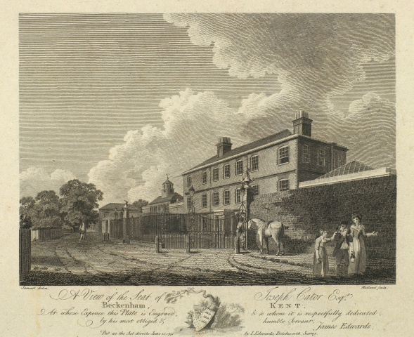
Clockhouse between Beckenham and Penge (looking towards Penge)
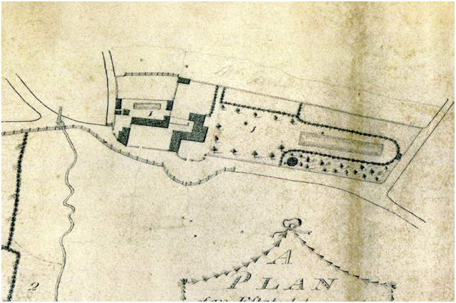
1783
– From the Ipswich Journal, The Stamford Mercury 13th February and The
Kentish Gazette on 12th February: "It
is surprising after
the many melancholy accidents that frequently happen from people going
out together
on shooting parties, that more care is not taken to avoid each other’s
fire. On
Thursday Mr. Cator and a servant of Mr. Hoare, the banker, went out to
take
this diversion from Beckeham, in Kent, when the latter discharging his
piece
without recollecting that his companion was near him, the contents were
chiefly
lodged in Mr. Cator’s arm, which, it is much reared, will prove fatal
to him.
Mr. Hoare, the moment he heard of it, humanely sent from town three
surgeons,
that the utmost care might be taken to recover him."
1783 - John Cator purchases
Wricklemarsh at
Blackheath, the house and estate of Gregory Page Turner for £22,550.
Some of the columns and windows came to Beckenham Place but the date is
uncertain. The large ground floor window is the same as at the sides of
portico. Although some accounts say John began developing the
Wricklemarsh estate into what is now Cator Estate at Blackheath, some
reassessment has re-dated most of the development process until later
after 1820 and at the instigation of Cator’s heir, John Barwell Cator.
As John Barwell Cator generally used just ‘John Cator’ as his name then
confusion has occurred in several respects as to which ‘John’ carried
out certain developments.
The Oxford Journal reports on the 12th April.:
On Monday last the
Mansion House and Park of the late Sir Gregory Page, on Blackheath,
were sold
by Auction, by Messrs Christie and Ansell, to John Cator, Esq. of
Stump’s Hill,
near Beckenham in Kent, for £22,550.
From The Kentish Gazette, 30th April 1783. The house at Blackheath, lately purchased of Sir Gregory Page Turner, by Mr. Cator, for £22,550 we hear is already sold to a gentleman from the East Indies, for the advanced sum of £28,000. But this sale it seems was not completed.
However, the Wikipedia entry for The Paragon, Blackheath states “Regency architect Michael Searles (1750–1813) was famous as an English commercial architect of large houses, particularly in London. His most notable achievement is perhaps The Paragon in Blackheath
Searles was the son of a Greenwich surveyor, also named Michael Searles (c. 1722-1799), who served (from 1765) as surveyor to Morden College in Blackheath. Searles and his father formed an unofficial father and son partnership producing plans in and around Greenwich before Searles junior set up his own practice.
Landowner John Cator granted development leases to Searles and builder William Dyer to design and build a series of high quality dwellings, intended to appeal to upper middle class buyers, situated on the south-east side of Blackheath. Facing the heath, South Row and Montpelier Row were erected from 1794 to 1805.
Its believed that the rest of the Wricklemarsh Estate was leased mainly for agriculture until the 1820’s
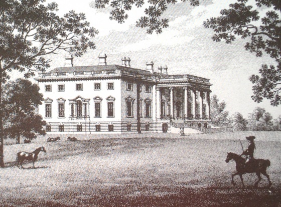
The pillars of the portico along with several ornate windows from Wricklemarsh House at Blackheath were added to Beckenham Place when much remodelling was carried out but the date is debatable. The Ordnance Survey surveyor’s preliminary sketches of 1799 in the British Library clearly show a house at Beckenham Place without the portico although the curved bay at the rear of the house and a stable block and a lake are shown. It is thought that Beckenham Place was originally red brick but that limestone ashlar covering came from Wricklemarsh along with the portico masonry. This could have been prior to 1800 but the map evidence puts it in doubt and the potential for John Cator’s heir, John Barwell Cator to have carried out alterations is a real possibility. W.H.Ireland’s History of Kent states that John Barwell Cator carried out extensive improvements to Beckenham Place, possibly including extending the house, improving and extending the stables or adding outbuildings, altering the lake etc. I remain open to new evidence regarding such changes.
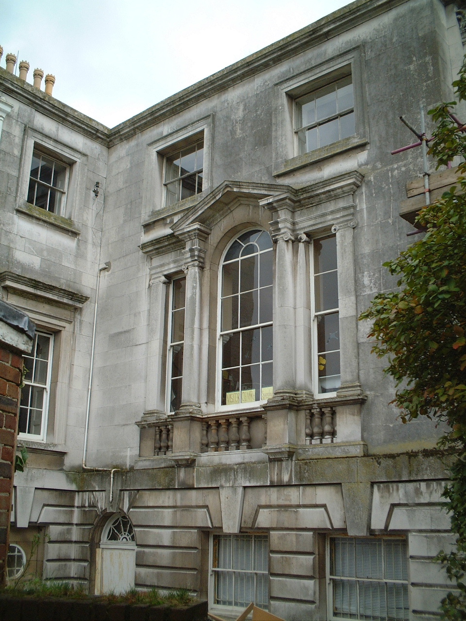
This window from Beckenham Place Portico is the same as in the print of
Wricklemarsh as well as other similarities in masonry
1783 – Also in this year Cator sues for compensation over his purchase of Beckenham Manor but is unsuccessful due to legal precedents it seems. It would be necessary to write a separate account of the full proceedings from the beginnings when Bolingbroke leased the Manor of Beckenham to Mortimer and Hare in 1769 to fully understand the circumstances. Cator finally gives up attempting to retrieve his costs from the process after another case in 1787. See 1773, 1780 and 1787. This extract partially shows how a complex trail of ‘where did the money go’ prevented Cator from retrieving his losses.
Hans Winthrop Mortimer is a co-lessee of Beckenham Manor with Mrs Margaret Hare. There is a record of him being discharged from the Fleet Prison which was a debtor’s prison in 1793, 1796 and 1797. Also, a Hans Mortimer being a victim of a theft three times between 1786 and 1803 of six pairs of stockings, some windows and some lead. In each case the thief was transported for seven years. He is also listed as a Justice of the Peace for Middlesex around that time. Several questions arise but of no real involvement in the Park but an interesting minor connection.
The Earls of Pembroke and Guilford were co-defendants in the case brought by Cator as trustees of the Beckenham Manor estate with Bolingbroke. The Earl of Guilford was the father of a Prime Minister, Lord Guilford who later inherited the title of Earl. Was Cator up against a hierarchical barrier?1784 – In a letter of 15th April to Mrs. Thrale, Cator is mentioned by Dr. Johnson as being at a meeting of Johnson’s ‘club’ with Metcalf and Crutchley who are MP’s for Horsham and mentions Cator is chosen as candidate for Ipswich. Cator is elected MP for Ipswich but unseated. The History of Parliament online describes John Cator's political career or in 'The House of Commons 1754-1790 by Lewis Namier and John Brooke' available as an e-book. Samuel Johnson dies on the 13th December 1784.
The daughter of Henry and Hester Thrale generally known as Queeney (Hester Maria) was staying with the Cators either at Beckenham or at The Adelphi as John had been appointed a Guardian to the three Thrale daughters. She was about 20 years old. The guardianship and Cator’s management of Henry Thrales will caused much friction between Hester Thrale and her new husband Gabriel Piozzi which continued almost until Cator’s death with several cases being brought before the Court of Chancery. (sources: Thraliana and Nat.Archive)
1785 - Cator has the road diverted to the current Beckenham Hill, Southend Road route and also closes Langstead Lane between Southend Green and Clay Hill. The new road is at first called Great Stumpshill Road. It is noteworthy that the pond we refer to as 'ancient' is clearly marked on the eighteenth century road diversion plan. The site of its farmhouse on the same side of the road is now mostly outside the park boundary and occupied by modern housing.

Courtesy of Kent History &
Library Centre, Maidstone.©
https://www.kentarchives.org.uk/collections/getrecord/GB51_Q_R_H_2_22’
Centre for Kentish Studies has this document: Part of highway between village of Southend in Lewisham and village of Beckenham, 1,500 yards long, to be diverted to a new line, through lands of John Cator , Esq., 1,518 yards long, 30 feet wide. Highway from Southend Green near vill of Southend to Clayhill in Beckenham, 2,250 yards long, to be stopped up, since it is disused, and the road from Southend to Clayhill by Beckenham Church is used in its place. Order: at Beckenham 22 March 1785, with plan (scale: 10 ins. to mile). Endorsed:consent of John Cator of Beckenham, Esq., same date Certificate of completion: 4 April 1785. Order enrolled 5 April 1785 [ Q/So.W11.pp529 - 530 ]
The
core of the park probably took most of its present form in the 1780's.
For it is then that the public was excluded from the park roads the
existing road becoming a driveway through his park and he also closed
another road called Langstead Lane (or Lagg Street Lane on some maps)
which ran from Southend to Clay Hill, effectively excluding the public
from his parkland estate. The gatehouses at the north and south ends of
the drive through the park still remain though the southerly one is now
outside of the public park being at the entrance to what is now a
private road confusingly also called Beckenham Place Park.
At this time the local gentry were vying with each other in improving their estates and almost all of them adopted what was then the height of fashion, large scale landscaping to produce vistas of pasture leading down to stretches of water with a backdrop of trees. The closing of Langstead Lane which would have crossed the footprint of the lake was probably with a view to creating the lake and excluding the public. Introduced species such as Turkey Oak, Holm Oak, Rhododendron, Swamp Cypress are or were present whether due to original plantings when Cator built his house or later landscaping. the Turkey Oak which blew down in 2002 was dated to 230 years of age (planted 1772 or earlier). Collinson remarks in a letter to John Bartram "my two sons (Cator his son in law and his own natural son) vye with each other in acquiring plants and ask Collinson for azaleas, khalmeias and rhodedendrons. Search The Memorials of John Bartram and Humphrey Marshal for Collinson's letter, it makes entertaining reading and an insight into the Collinson/Cator relationship. Collinson was a supplier of many plants to a wide number of clients including the aristrocracy. However, the passage of time, changing fashion and various tennants have had an impact on the landscape.
We
believe Cator owned the property both sides of the driveway through the
park even as early as the date at which he built his house (1762). The
farms probably continued in operation to manage the land. The lake was
installed at the most practicable position, a low point on level land
around the foot of the hill now called Summerhouse Wood but called
Lewisham Lands on Foxgrove Manor maps. The lake was fed by the stream
running along the valley below the house which came from springs near
Foxgrove Farm and Moat. The lake overflow which we assume would have
been continuous flowed on through his land to meet the Ravensbourne
river. After the railway was constructed much later the overflow had to
be taken under it via a conduit. The lake as well as providing a view,
provided some sport fishing and perhaps wildfowl shooting. We don't
think that boating and swimming were great Georgian passtimes but Cator
is recorded as going on barges on the Thames for social occasions. It
is said that in the late 19th century the installation of the West Kent
Sewer diverted spring water and Foxgrove Farm moat dried up and this
probably affected the feeder stream to the lake. Other reasons for
drying up could be the lake bed losing any waterproof quality. It was
probably puddled clay similar to the method of waterproofing canals, in
fact early landscape stretches of water were called canals, see the
diary of John Evelyn.
Cator also buys the title to a cottage in two tenements with several pieces of land in Lewisham received in exchange from Francis Motley Austin Esq of Court Lodge, Lamberhurst on 9th May 1785 with Cator paying £600 by way of equality of the property (source P.Manning from record at Kent Archive). The exact whereabouts of the property is unknown. Francis Motley Austin or Austen is an extensive landowner in Kent from Beckenham to Sevenoaks and an uncle to Jane Austen's father. He acquired the Manor of Billingham (Bellingham) which I assume to include Bellingham Farm Catford.
The Burrell's of Langley Park also diverted a road away from the front door of their house, it now constitutes South Eden Park Road and another between Langley and Elmers End was widened and as this record states:
Part of highway between Langley and Elmers End in Beckenham, 1,232 yards long, to be diverted to new line through lands of Sir Peter Burrell of Beckenham, knight, 473 yards long, 24 feet wide. Other parts of the said highway, 2,206 yards long, being narrow, be widened by addition of parts of lands of John Cator of Beckenham, Esq., Amey Burrell of Beckenham, widow, and Sir Peter Burrell.Footpath from Langley to Cage or Watch House in Beckenham, to be diverted into highway from Langley to Beckenham Church, and thence to the said Cage or Watchhouse. Other highways and footpaths in Beckenham, shown on plan [now missing] to be stopped up as unnecessary, reserving rights of way to owners and occupiers of adjoining land.[The papers concerning these diversions etc are missing.] Order: at Beckenham, 3 September 1784. #Consent of J. Cator, Amey Burrell and Sir P. Burrell, 3 September 1784.Certificate of completion: at Beckenham, 2 October 1784.
Held at Kent History and Library Centre Document Order #:Q/RH/2/18Y
 The three
plans of Foxgrove Manor, Beckenham Manor and the road diversion plan
shown side by side will explain how there was a farm or messuage on the
opposite side of the road from the mansion between Foxgrove and
Beckenham manors and apparently not part of either of them. But
nevertheless acquired by Cator. As the plans are orientated in
different directions they have to be rotated to align with the same
compass point.
The three
plans of Foxgrove Manor, Beckenham Manor and the road diversion plan
shown side by side will explain how there was a farm or messuage on the
opposite side of the road from the mansion between Foxgrove and
Beckenham manors and apparently not part of either of them. But
nevertheless acquired by Cator. As the plans are orientated in
different directions they have to be rotated to align with the same
compass point.
1786 – Carey’s map of 15 Miles around London shows the Beckenham area with the Beckenham Place site in the name of Cater Esq. No lake is shown whereas the lakes in Kelsey are shown. Stumps Hill is identified as ‘Stamphill’. Several place names are questionable.
1787
– Cator’s mother Mary dies in this year and is buried on the 31st of August at the age of 78 in what
becomes the family vault St. George’s parish churchyard Beckenham. Her
abode is given as Bromley in the Beckenham burial record. Mary did not leave a will it seems but she had been left money and
houses or at least the income from them from her husband. What
does emerge some time later as a result of research by Keith Baldwin is
some letters from Mary to her son Samuel left with a Mrs Ardouin of
Greenwich to be sent to Samuel after her death concerning some money
left in Bank of England Consols. Mary expresses sadness at Samuels
state of affairs and it seems he lived beyond his means getting into
debt on more than one occasion. Samuel dies the next year, see 1788.
She asks him to use the money wisely after his affairs are straightened
out. But later amends her instructions to Mrs Ardouin, requesting that
the money is divided between Samuels daughter and another granddaughter
by marriage to the Sparkes family. She asks that William Cator is used
to carry out the wishes, but Samuel dies soon after his mother and
William is also killed without disposing of the money and somehow Mrs
Ardouin left the stock in her will to be sorted out with the Cators
after all the beneficiaries had died. The letter reveals Mary's great
distress at Samuel's disposition.
Cator
buys Grangewood in Upper Norwood as part of his acquisition of the
Manor of Whitehorse or Bensham, now a public park among the other land
which was used for house building after John Barwell Cator sells it
later on. Just another example of Cator’s acquisitions. Maybe or
probably part of the same purchase as Cator also purchases the Manor of
Croydon according to History of The County of Surrey by Thomas Allen.
This must be the Manor of Bensham or Whitehorse and include parts of
what is now Upper Norwood and is listed in the 1825 Act among the other
properties and consists of about 560 acres. In the 1825 Act it is
identified as ‘to be sold’ by J.Barwell Cator to pay for other land in
Kent, Surrey or near Woodbastwick. Cator ownership of lands in Croydon
may have been as short as 20 years? Having looked at land dealings of
others such as John Evelyn, buying and selling estates was common and
frequent. As banks and investments were perhaps less divers then
investing in land was perhaps seen as safer than other forms of saving.
From The Ipswich Journal 09 June 1787; The celebrated house of Sir Gregory Page,Bart. on Blackheath, was build about 60 years ago, and, from the superior excellence of the materials through all the component parts, was confessedly the first habitable house in this kingdom; the whole expenditure fell but little short of £135,000. The building was sold by Sir Gregory Page Turner, a short time since, to Mr Cator for £22,550. who has now nearly completed the sale of this noble structure, in a manner that dooms its immediate dissolution - by lots!
Also, in this year 1787 Cator’s brings a case against Lord Pembroke in the Court of Chancery. It relates to the purchase of the Manor of Beckenham from Lord Bolingbroke in which it seems Bolingbroke omitted to reveal certain circumstances to Cator. i.e. He had leased it on a ‘rent back’ arrangement to Mrs Margaret Hare and failed to pay her the rent of £500 per annum. Cator had to recompense Hare to gain full control of Beckenham Manor. Bolingbroke was supposed to purchase other lands with the proceeds but invested the money in annuities which he assigned to a Mr. Boldero.
I wonder if this is how Chancery Lane in Beckenham acquired its name? But when we look at Chancery cases it seems landlords were pursuing one thin or another almost weekly.
Cator probably thought it not worth suing Bolingbroke directly for compensation as he was (Boling) broke.....it seems he had been juggling his debts for some time, leasing and selling off assets and the involvement of ‘trustees’ such as Pembroke and Guildford requires some disentangling. From Wikipedia: Things worsened for Viscount Bolingbroke after his divorce. The damages he won from Beauclerk (for his adultery with Diana) were paltry compared to the mountain of debt he acquired. Rather than economize he chose to sell his prized racehorse. Even before his divorce his tight finances led to his sponsoring changes in law that allowed inheritors to sell off family properties. Once the law was passed he set about selling property that had been in his family for centuries. In 1763 he sold the estate of Battersea, Surrey to Viscount Spencer. Eventually, he begged for and received a post as Lord of the Bedchamber in the court of King George III—a post he'd previously held while still married to Lady Diana, but given up due to a combination of disinterest and indolence. In the meantime he never stopped searching for an heiress old enough or unattractive enough (and therefore desperate to marry) to wed a man of questionable finances and reputation. This led to laughable "courtships" with well-bred spinsters, including one who herself had lost her fortune to gambling.
From a later press article, Cator sells the fabric of Wricklemarsh House at auction in lots: June 1822 Manchester Mercury: A press article about Wanstead House compares the fate of Wricklemarsh. The fate of this admirirable mansion, Wanstead House, reminds us of that which befel the magnificient seat of the late Sir Gregory Page at Wricklemarsh on the western side of Blackheath. this consisted of a centre united to two wings by a colonnade and was adorned with masterly paintings, hangings, marbles and alto relievos. Sir Gregory died in 1775 and left this seat to his nephew, the late Sir Gregory Page Turner, who took the name and arms of Page. Sir Gregory Page Turner disposed of the noble collection of paintings by auction and by virtue of an act of parliament the house and grounds were sold by auction to John Cator Esq. of Beckenham for £22,550. This gentleman sold it again by auction in 1787, in a very different way; all the materials, with its costly decorations, having been disposed of in seperate lots.
Again this presents a possibility that Cator added the Beckenham Place portico or the materials were unsold and left lying around. J.M.W.Turner painted the ruins in the 1790's and as Wricklemarsh was gigantic it is perfectly possible that substantial masonry was left.
1788 – Cator’s brother Samuel dies in Jamaica where had been employed as a customs official, leavin a wife, Bridget and young daughter, Mary who dies aged about 8years old in 1793.
Pat Manning’s research at Kent Archive records an exchange of lands from Lees Court, Kent with certain lands in Lewisham for which John Cator paid over £550 for equality 19 November 1788. These would probably have been Earl of Rockingham/Sondes/Lees Court lands which are identified on the Foxgrove Manor plan as being in the area of what is now Downham/Southend. The Rockingham connection is certainly complex. It seems that the last Earl of Rockingham died in 1746 without a direct heir and the Earldom became extinct. Lewis Watson 1st Earl of Rockingham had married Lady Catherine Sondes daughter of the 1st Earl of Feversham (Faversham). His title passed to his grandson also named Lewis Watson who styled himself Viscount Sondes. He was succeeded by his brother Thomas who died in 1746 without a direct heir. So far as I can see he was succeeded by Thomas Watson-Wentworth, 1st Marquess of Rockingham, KB, PC (I) (13 November 1693 – 14 December 1750) was a British peer and Whig politician. The succeeded by Charles Watson-Wentworth, 2nd Marquess of Rockingham, KG, PC, FRS (13 May 1730 – 1 July 1782). In 1782 with no heir The Marquess of Rockingham title also becomes extinct. But the property would pass back along another branch of the family and they, probably having no local interests must have sold this part to John Cator. Perhaps the estates reverted to the Sondes family who had large estates in Kent.
This extract from the 1833 estate plan may indicate where the land acquired from Rockingham was situated, around the bottom right hand corner if we compare it to the 1776 Foxgrove Manor plan.
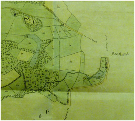
Also
refer to the 1795 purchase of land from John Forster at Southend which
would also be on this 1833 plan.
This
record in Lewisham Archive also illustrates Cator’s dealings around
this time:
Mutual release and conveyance Hon. Lewis Thomas Watson To John Cator
and James Farrer his trustee. Details of land, acreages, boundaries,
etc. Refers to lease by Indenture by Rt. Hon. Lewis Lord Sondes to John
Cator, dated 1st November 1784 for 21 years Refers also to Lease and
Release dated 7 and 8 August 1764 between Paul Whitehead, etc. Refers
also to Indentures of Lease and release dated 18 and 19 December 1787
1788
- John Cator negotiates lending money via bonds to the Prince of Wales
(later to become George IV) but he and another party withdraw before
the transaction is completed (Memoirs of George IV and Memiors of
William IV). These books are available on the internet "The history of
the life and reign of William the fourth, the reform monarch ...By
Robert Huish "
As the Princes were anticipating being able to repay the bonds upon the
death of their father George III the lenders, Cator and others could
have been held as ‘treasonable’. The circumstances surrounding the
financial position of the Prince of Wales later Prince Regent and
George IV are even more astounding as some Dutch bankers were found to
make a loan. They issued bonds in Europe and Napoleon invaded Belgium
and Holland giving the Prince of Wales an excuse not to repay the loan.
The Dutch bankers were left bankrupt and both committed suicide. This
extract is from the book. It goes further to explain that some French
royalists advanced money against these bonds and seemingly some of them
were found treasonable in France for lending money to an enemy during
the Napoleonic wars and subsequently executed. The book requires
reading to fully understand the circumstances. In any case, Cator
either had a close call or had he continued with the transaction he may
well have been raised to the Peerage on the crowning of George IV.
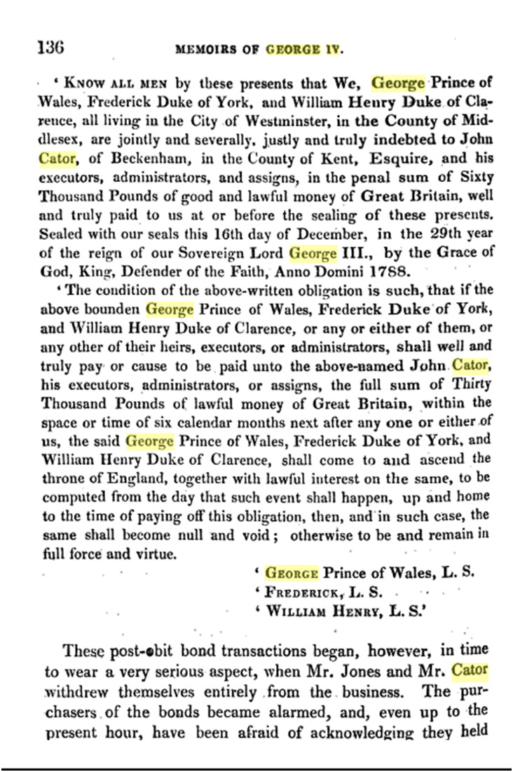
1788
- In what appears to be another Cator purchase of land, the Kentish
Gazette of February 5th carries and advertisement for the sale of
Chittenden Farm near Hever totalling 193 acres. It ends up in Cator's
list of property in the 1825 Private Act of Parliament. See 1825 for
the Act of Parliament and 1826 for the subsequent sale under John
Barwell Cator. Along with the Wricklemarsh purchase and the abortive
attempt to lend money to the Prince Regent Cator is apparently well off
for cash at this time. His shooting accident on the property of
Henry Hoare implies a good relationship with this banking family which
might lead to further discoveries about his business activity.
Also
1789 – Cator alters the course of the Beckenham to Bromley road at Clay
Hill but comparing maps of before and after the change seems minor,
maybe straightening and widening. The map shows a rerouting taking the
road a bit further away from the front of what is now Bishop
Challoner's School ex Shortlands House.
Description:Part
of highway at Clay Hill between town of Beckenham and town of Bromley,
305 yards long, to be diverted to new line through lands of John Cator,
Esq., 302 yards long, 20 feet wide.
Order: at Beckenham, 7 September 1789, with plan, surveyed by J.
Corbett, Lewisham.
Endorsed:
consent of John Cator of Beckenham, Esq., same date. Certificate of
completion: 7 January 1790.
Held At: Kent History and Library Centre
Document Order #:Q/RH/2/33
Date:1789
1790 – December 23rd, a great storm of thunder and lightning destroyed the spire of St.George’s Beckenham, and the greatest part of the church by fire; it had been repaired, and restored to its former state but rebuilt later between 1885/87, it would appear with some loss of heritage features such as effigy tombs.
1790/93 - John Cator is MP for Stockbridge. This would be his final seat in parliament. His entry in History of Parliament online makes interesting reading.
1792 – Cator publishes ‘Answers to the Complaints of Hester Lynch Piozzi and Cecelia Thrale’
John
Cator 1792
- 672 pages
Cator's 1793 Nov. 21 response (with fellow executor Jeremiah Crutchley)
to a complaint from Henry Thrale's youngest daughter Cecilia (later
Cecilia Mostyn), then a minor, filed by her advisor Bertie Greatheed.
In the response, Cator expands on his narrative of his handling of the
Thrale estate, including transcripts of schedule of accounts through
1785 Sept. (pp. 130-169), June 1787 (pp. 170-185), 1792 July (pp.
186-206), 1793 Mar. (pp. 206-212), and 1793 Aug. (pp. 213-237). It is
signed by Cator and Crutchley on p. 129, by witness John Ord (p. 1),
and by James Trower (transcriber?) (p. 129). A payment from the estate
to "Gabriel Piozzi, music master" is listed on p. 142.
Cator had acted as money lender , joint will executor and joint guardian of his children for Henry Thrale. Hester Thrale had remarried Gabriel Piozzi. This is of no impact on the Park but indicative of Cator’s financial dealings.
1792/3 - John Cator acquires the remainder of Foxgrove Manor in a land rationalisation exchange with Peter Burrell III of Langley who will attain the title Lord (Baron) Gwydyr. (source: Edward Hasted 1797)
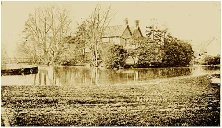
Foxgrove Farm later circa 1870 ?
This
exchange involved more of the lands Cator had
amassed south of Beckenham village from the descent of Foxgrove land
via the Tolsons, Tillys, Bridges and Groves. A later Cator estate plan
of 1833
excludes any property south of the village. It appears that both Cator
and Burrell are concentrating their holdings into large contiguous
areas, the 1809 Burrell map shows land all to the south of the village.
Some details of the 1793 exchange, Burrell to Cator: Foxgrove &
common called Boyland, capital messuage or mansion house at Clay Hill
with stable, appts, garden, orchard & fields late occ Rev Wm Rose
and lands at Clayhill. These latter may be the Oakery as Cator had
earlier acquired Woolseys Farm, now Shortlands House/Bishop Challoner
School through the purchase of Beckenham Manor.
Cator to Burrell; Stone Farm, Stone Field otherwise Barn Field formerly called the stone lands 4 pcs Gattons Mead 2a occ Samuel Parson then Robert Lloyd as bought from Joseph Grove (except Gattons Mead) formerly given to Peter Burrell by John Cator, Home Field, Grove Field occ Richard Henry Alexander Bennett Esq purchased by Cator from Lord Bollingbroke and Pikehill Green.
Burrell holds Shortlands House in 1798 (land tax redemption) though he has become Lord Gwydir by now. Bromley archive has these documents: Abstract of title, 'number 5', of the trustees of the Right Honourable Peter Lord Gwydir, deceased to estates in Kent to be given in exchange to John Cator, esquire. Begins with will of Lancelot Tolson, 25 February 1726[/7] and covering dates 1726[/7]-1793, with details of date of deed, type, parties, property and terms.
Also
in this year; Part of the highway between village of Beckenham and
village of West Wickham, 563 & 3/4 yards long, to be diverted to
new line through lands of Sir Peter Burrell of Langley Park, baronet,
563 & 3/4 yards long, 36 feet wide.
Order: at Beckenham, 4 March 1793, with plan, surveyed by John Sale,
Bromley.
Endorsed: consent of Sir Peter Burrell, same date; certificate of completion, 8 March 1793. The plan for this diversion (now missing) shows lands belonging to John/Jno Cator next to Burrell’s land. This may be associated with the aforementioned exchange and may mean the ‘1780’ map is neither 1780 nor 1768 but actually 1793. (source Kent Archive)
If it is a map of 1793 then maybe all the ‘Cator’ sites are those exchanged that year. The map seems to be from Burrell records and maybe the missing half of the map is in Cator archives so far undiscovered or lost.
1794 - John sells the Bankside business and property (source:
P.Manning). Maybe this is prompted by the death of the younger brother
Samuel in 1788 who was intended to be taken into the business as
apprentice and partner. We can only guess until information is
forthcoming. John is aged 66 so without a family member wanting to take
over the business he is perhaps reorganizing his assets. One would
imagine that he had employees managing the business during his other
business activities and political career.
Cator grants a lease 20/10/1794 Lease from John Cator of Beckenham, Kent, esquire to James Graham of Lincolns Inn, Middlesex, esquire of a piece of ground called Smith's Croft adjoining the mansion house of Graham and lands called Pond Croft, East Brook and West Brooks in Beckenham for 30 years at the annual rent of £60. Includes an assignment of the lease to Henry Jackson of Beckenham, dated 25 December 1794. Bromley Historic Collections ref 853/1/1/1/46
This property is not in the park but between what is now the High Street and Rectory Road and may be the grounds of Village Place.
1794/5 – Probably outside of the ‘Park’ but on the edge by what is now Brangbourne Road; A record of a conveyance of a messuage, water corn mill and lands in Southend, Kent from John Forster Esq. of Lincolns Inn, Middlesex, to John Cator of Beckenham, Kent in consideration of the sum of £1750. Maybe including some part of the park by the Ravensbourne but unlikely? 02/01/1795Attested copy conveyance of a messuage, water corn mill and lands in Southend, Kent from John Forster of Lincolns Inn, Middlesex, esquire to John Cator of Beckenham, Kent in consideration of the sum of £1750. Bromley Historic Collections ref. 841/1/5/16
..... land at Southend purchased from John Forster Esq of Lincoln’s Inn for £1750 on 1st/2nd Jan 1795 detailed as Flowers Garden, 3r 1p, Tree Crafts, 4a 1r 31p and Sand Pitt field 3a 1r 22p.
This last undated record is likely to be at least partly in the ‘Park’.
The document relating to this is complex and involves an exchange with Cator leasing the Green Man public house, a bakers and cottages to John Forster. Cator acquires a mill with dwelling occupied by Mr. Nattress, It discusses enlarging a mill pond to increase production by removing a garden and fish pond. This can help position the mill on the 1833 estate plans (I hope). The 1833 Cator Estate map (part below) does indeed show a mill and millpond, dwellings and a separate pond which does appear to have been used to extend the millpond on the OS map. However, this mill and the pond are long gone. This section of the map shows a small brook joining the Ravensbourne assumed to come from what is now Shaftesbury Park in Downham.
The fifth abstract concerns land purchased from the widow Jane Weatherall of Deptford by John Cator of StumpsHill for £850. It is described as “All that one close of pasture and arable called Broomfield 7 acres and one close of pasture or arable. Called Two Acres adjoining Morrices Wood, also 2acres of meadow lying in Rookey Meadow adjoining East lands, also Bullocks Meadow 2 acres and a pasture called Three Acres.” Proof of ownership was provided by the inclusion of the will dated 11.2.1735 of Robert Friend gardener of Deptford who was Jane Weatherall’s father. (source: Pat Manning from research at Kent Archive)
Of the above, the last one mentions Morrices Wood, called Morrifs (Morriss) Wood East and West on the Foxgrove Manor Map. It is likely these are the same plots and perhaps this land is around ‘A’ Earl of Rockingham’s land on the 1766 Foxgrove plan. The land at A on the Foxgrove plan is described as being grazed by oxen which may be the Bullocks Meadow mentioned here? and perhaps East Lands is adjacent to Morriss wood and Lewisham Lands. Until we find a relevant estate plan, if one exists, this is conjecture. The Ordnance Survey drawing shows Southend in about 1799 and the estate plan of 1833 shows a millpond and the mill? It is possible to identify the positions of pubs, mills and Flower House as well as lodges at the park entrance. The Ravensbourne was the source of power for several mills along its course.

From
the 1833 estate plan showing the area around the mills at Southend. Bromley
Historic Collections
The blank area includes land around Flower House. William Flower died in 1789 ‘Probate of will of William Flower of Southend, Lewisham, Kent, esquire, granted 15 August 1789. Bequeaths to his sister, Elizabeth Flowers, a house in Southend and all other freehold and leasehold estates. Daughter Frances Flowers. She is also to act as executrix.’
Flower House survived until WWII and was an asylum for the insane in the 1911 census. Despite some conjecture that it was part of the Cator estate it seems it was not. A housing estate now stands on the site.
1795 – Between 1795 and 1806 John Cator has the Paragon built as Blackheath on part of the Wricklemarsh estate. Designed by Michael Searles. Blackheath is extensively written about by other authors.
1796 – Daniel Lysons publishes Environs of London volume 4 with entries for Beckenham. He draws on information from Thomas Phillipott and Edward Hasted with some additions.
1797 - Croydon Enclosure Act; (source Wikepedia) between 1750 and 1850 there were many Enclosure Acts which allowed landowners to exclude people from what was Common Land with access to all for grazing, growing some food, foraging and pannage. The Croydon act allowed the enclosure of what included Crystal Palace Park. There is some anecdotal evidence that the Cator estate had at least some of this land and sold it to the Crystal Palace company. This story needs confirmation and is included here to illustrate how public access and use can be lost all too easily. Of course you might have to go back to Adam and Eve for the first enclosure of the Garden of Eden for history of this aspect of property ownership.
1799 - The earliest version of the Ordnance Survey map of Kent. Not published by the OS until 1860's but printed by other publishers such as Stanford's reproduced by kind permission of the British Library. This map shows clearly how the lake is supplied with water from a stream and pond. The pond is now filled in and in a school playground. By 1799 the Ordnance Survey surveyors working drawing (below) in the British Library and viewable on their website, shows the park and nearby details. Some field outlines are still similar to the 1766 Foxgrove Manor plan. John Cator has removed field boundaries inside much of his 'park' landscape.
A farm to the south of the mansion still exists as it had been on the 1785 road diversion plan and it is still visible on some early 1800 maps but gone by 1860. A house in the now private road “Tudor Manor” may have acquired its name if some remains were discovered at the time of its building (. The buildings of home farm are just visible between the stable block and Southend Lodge. The field pattern here may relate to the 1795 land transfer? Land marked with stripes is cultivated, woodland is apparent, mottled land is probably pasture and parkland marked with less dense concentrations of trees.
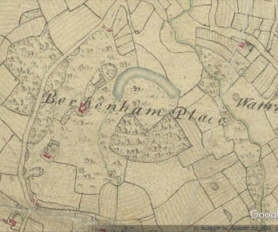
This 1799 map is accessible on the
British Library OS map collections website, this is only a small extract
1799 – Hasted’s 2nd edition of his Topography and History of Kent is published, perhaps prompted by the Lysons publication of Environs of London. The new publication is said to contain new material and edits.
1797
– Mrs. Cator of The Terrace, Adelphi is listed as a donor of 5 guineas
to an orphanage. Reading the on-line book is ‘insightful’ to say the
least about the conditions of orphans at this time. The 'progress' made
from the establishment of the Foundling Hospital in 1739 is slow, and
extreme poverty persists.
Overview:
After
Mary and John Cator’s deaths, John left the estates in the hands of
several family trustees making complex bequests. Whether John intended
the Beckenham estates to be developed is in doubt, by me and a few
others at least, although some development of the Wricklemarsh,
Blackheath estate had taken place. Between the time of his death and a
Private Act of Parliament in 1825 brought by the remaining trustees,
some of the trustees had died intestate thus the primary heir, John
Barwell Cator, son of John Cator’s brother Joseph, gains control of the
estates and resides at the Place for at least some of the time. He buys
estates in Norfolk, visits Ireland regularly or for substantial periods
and spends less and less time in Beckenham. After about 1840 the Park
is mostly leased to a series of tenants. But other events affect the
park such as the building of the railways and inheritance of the park
by John Barwell Cator’s descendents. The Trust by which the estates are
managed will perhaps never be fully understood, but John Barwell
Cator’s brother Peter is reported as managing the Beckenham estate upon
his return from being a magistrate in India. The pace of built
development of the estates was dictated in part by the demand for
housing and at least once that process stalled when demand was low.
J.Barwell Cator along with his father Joseph and siblings as trustees
were involved in further purchases of land including the enclosure of
Penge Common and development of the Croydon Canal and later the
railways. Apart from being landlords of the properties involved it
seems the main protagonists for development where other entrepreneurs.
Return to timeline:
1800 - Wricklemarsh, Blackheath; dated 1st April an engraving of Wricklemarsh in a state of demolition showing columns, window masonery. Described as Sir G.P.Turner's Houise, Blackheath and attributed to James Peller Malcolm (Philadelphia 1767-London 1815).
The picture adds to my view that the addition of a portico to Beckenham Place with materials from Wricklemarsh is after John Cator's death in 1806.1801 – John and his brother Joseph are active in local affairs. Press cuttings on an online archive reveal how John is influencing church wardens Thomas Pool and David Bassett who are required to set a rate to provide relief for the poor. The poor rate is not set and accusation is that Cator and other ‘local persons and Noble Lords’ are used to influencing this process. A Mr Jackson, a merchant, has the church wardens prosecuted for not fulfilling their duty. It would appear that Cator stays in the background but his identity is revealed in proceedings. The two churchwardens are confined in Kings Bench prison for contempt.
Subsequent to this legal case, Joseph Cator is prosecuted and found guilty of libel against Jackson, apparently an attempt at revenge by Joseph Cator for his brother John. A significant piece of evidence in the case is the fact that letters containing the libel are on paper only supplied to Joseph Cator and the Bishop of Rochester who resides at the Bishops Palace in Bromley. Joseph’s defence lawyer is George Wickes. The Cators and Wickes families are related by marriage.
Reference is made to John Cator’s experience with the law, perhaps referring to his suits against Bolingbroke’s trustees over the purchase of Beckenham Manor and other cases. As well as his time as Sheriff of Kent and as an MP and to his differences with Hester Thrale over Henry Thrale’s Will.
1802 – John Cator is implicated in another court case at Maidston Assizes for an unwarranted eviction a tenant from one of his fields. A Mr Jackson sues Cator for damages. The case is prosecuted by the barrister Garrow. Cator is made to pay £100 damages.
1804 - Mary Cator dies and is buried in St. Georges churchyard with her daughter.
1805
– John Cator prepares his Last Will and Testament, mentioning
properties in Kent, Surrey, Essex and Middlesex. These include his
Mansion at Beckenham Place and an estate “situate near Addington”.
Copies are in the National Archive, Surrey Archive and Prerogative
Court of Canterbury Wills. Middlesex may refer to his Adelphi
apartment? It must be remembered that County boundaries have been
modified. The original Southwark based business was in Surrey as were
any properties in Croydon, Norwood and Addington. The will copied into
the records of the Prerogative Court of Canterbury Wills extends to 21
pages of difficult to read handwritten text. The original presumeably
in John Cators handwriting is in the National Archive at Kew. Several
of Cators nephews are mentioned including George and Henry Sparkes,
his nephews by his sister Mary. His inention was that the estates
remained intact and
this leads to the later 1825 Act sought by his heirs to allow the break
up of the estate. See 1825.
1806 - John Cator dies at his apartment in the Adelphi near The Strand and is buried in St George’s churchyard, Beckenham with his wife and daughter in the family vault. Having lived on Bankside in Southwark near his business and later acquiring an apartment in the Adam Brothers Adelphi near the Strand Cator was a man of property and we can only speculate on how he accumulated his wealth. Referring to Pat Mannings “Cators of Beckenham and Woodbastwick” will give details of John Cator’s legacy. His Will was complex and the assets extensive. The later Act of Parliament of 1825 listing properties is enlightening.
The family tomb bears this inscription:
JOHN CATOR, late of Beckenham Place, 21st February
1806 aged 76 years/ MARY his wife 13th August 1804 aged 71
years/ MARIA their only child April 1766 aged 3 years/
MARY his mother 28 August 1787 aged 78 years/ ANN his
sister 27th July 1766 aged 17 years/ MARY daughter of his brother SAMUEL August 1793 aged 8 years.” (source: P.Manning)
1806 – John Barwell Cator marries Miss Elizabeth Louisa Mahon, a niece to Lord Vigo.
1806-1825 - John Barwell Cator (1781-1858), son of John's oldest brother Joseph, ultimately inherits the estate with other trustees although substantial assets are directly left to him in the Will. It is held in trust by his father Joseph until Joseph's death in 1818. But not before two cousins of Barwell Cator who are also named in the will die before majority and hence the whole estate becomes J.Barwell Cator's via an act of parliament, though this has yet to be fully unravelled and Pat Manning’s account of it is the best thus far so please read her book. According to John Cator’s will of 1805, No one person was left in charge of his estates and there were strict instructions in the will to keep the estates intact, avoid cutting down timber, defacing or destroying the land. He also wished that the property should remain in the family and be passed from father to son. Subject to limitations and conditions, Beckenham Place, all Manors and herediments in Kent, Surrey, Essex, Middx, Hereford and elsewhere including an Addington estate were left in trust to George Sparkes and Henry Sparkes, sons of John’s deceased sister, Mary Sparkes. Sarah Cator, the widow of his late brother William was left an annuity of £60 pa for life. £20 p.a. annuities went to Bridget Cator, widow of Kingston, Jamaica and Elizabeth Scott of Rodborough, Glos. Susannah Scott, Elizabeth’s daughter received dividends from bank annuities, similarly niece Harriet Heapy and great-niece Mary Ann Sparkes. Ann Frances Baynes, wife of Lt Col Baynes and daughter of John’s late brother William received £2000. By 1825, the Cators found the estates impossible to administer because the Sparkes brothers had died intestate and their heirs were all minors.
They submitted a private Act dated 27.6.1825 to King George IV to enable the descent to go down through Joseph’s eldest son, John Barwell Cator. (source: P.Manning “Cators of Beckenham and Woodbastwick”)
John
Barwell Cator 1781-1858
1806 - Building leases begin to be sold for parts of the Wricklemarsh, Blackheath estate. There is some debate about the alterations to Beckenham Place Mansion. Possibly John Barwell Cator having acquired great wealth through his inheritance indulged in adding the portico to the mansion and remodelling the lake as part of his spending spree. Without written records the maps available are a source of information. In 1799 the mansion appears on a map without a portico and it’s unlikely that John Cator the younger would engage in such alterations at this late stage in his life. The lake is of a different shape in the 1799 and later maps. The print of 1812 shows the portico and the maps of about 1860 show a different lake outline.
This description is from the 2009 Conservation Management Plan produced by Rees Bolter Architects:
Although the fabric of the north wing is of considerable archaeological significance, the architectural relationship between the extension and rest is clumsy and it is hard, almost impossible, to believe that the patron of the first house could have sanctioned such work. The survival of the shell of Wricklemarsh into the nineteenth century and the internal character of the extension make it far more likely that the extension was the work of John Barwell Cator, undertaken in the whirlwind of expenditure following his inheritance, to impress his new wife and family. Major expenditure on country houses usually follows a change of ownership. The wing has, within this report, generally been referred to as work of c1810 although no secure dating has been established. The new wing required the main hall to be approached along a rather long central corridor, with long rooms flanking it on each side. The overall impression of the new wing is that it was conceived as a showcase for masonry salvaged from Wricklemarsh, compromised by the levels existing within the original house. The pediment supported by the columns is visually too light and the rooms on each side of the central corridor are ill-proportioned. The additional accommodation was, presumably, welcome.
1807
- J.Barwell Cator buys land at Woodbastwick, Norfolk. This is the
beginning of the gradual move away from the Beckenham estate (source:
P.Manning, see her account on
www.bblhs.org.uk/download/i/mark_dl/u/4010072272/.../Cator%20Pre2.pdf)
1808
- John Barwell Cator’s wife’s relative Mr Aylmer Bourke Lambert has
access to Barwell's papers inherited from Peter Collinson via John
Cator at the mansion. Lambert's letter to James Edward Smith of the
Linnaean Society in their archive is the route which leads to
Collinson’s revelation about the date of the mansion. Lambert made
copies of the catalogue which became the property of Lewis Weston
Dillwyn who printed the version which we can now access on the internet
and reveals the first date of the mansion at Beckenham Place.
Lambert comments about J.Barwell Cator "who has just come into all his
uncles immense property" and "Cator has lately married a relative of
mine Miss Mahon, a niece to Lord Vigo"
1809 – A Burrell Estate map and book of plans is printed (source: British Library) showing their estates to the south of Beckenham. Also in this year J.Barwell Cator sells The Manor of Bensham/Whitehorse according to Lyson’s but the 1825 Act still lists extensive property in Addington, Croydon and Norwood? Very little has been discovered about the Cator property beyond Beckenham. Historians in some of those outlying areas are also unaware of details.
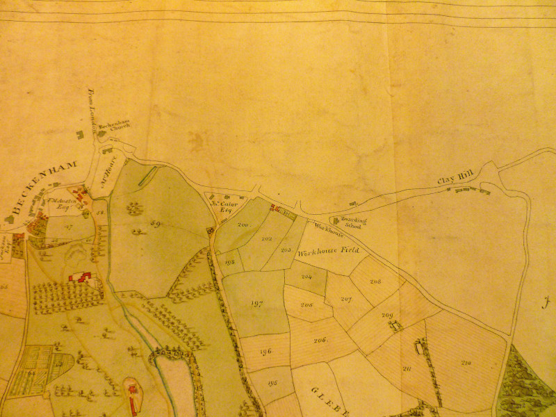
Part of the Burrell Estate plan 1809 (High Street, Bromley Road and Kelsey)
Courtesy of the British Library
1810
– John Barwell Cator's daughter Elizabeth Diana Cator born in
Beckenham 27th
July. She will marry Dennis Henry Kelly in Ireland in 1832
demonstrating the strong links with Ireland through John Barwell
Cator's marriage to Elizabeth Mahon.
1812 - Mr. Lambert, a relative of John Barwell Cator’s wife Elizabeth Mahon, visits Beckenham Place where he sees Peter Collinson’s catalogue of plants and also comments on the grounds of Beckenham Place “When I visited these grounds in 1812 I was much struck by the remarkably healthy appearance of many fine trees, including, as nearly as I can recollect, Cedars, Exotic Firs, Linodendrons and many large North American shrubs whose ages by this memorandum may be nearly ascertained”.
This view can be compared to Collinson’s own view of Beckenham Place or Stumps Hill as it was in 1762:
The trees which survive of evident age are native English Pedunculate Oaks, introduced Turkey and Red Oak, Sweet Chestnut (introduced by the Romans). Over time several oaks which may have been landscape boundary marks and field boundaries have died. Lack of tree management may have led to loss of trees and some ancient trees have been removed either by human interference or storm damage as with the storm of 1989.
1812 - J. Preston Neale produces a print of the Mansion in a book of country houses, although the pediment on top of the columns is not drawn accurately. It does depict how it perhaps should have been built. Preston Neale's work was published from 1812 to 1825 so different dates may be attributed to this print but it appears in the earliest edition. The book of prints has a description which may be of questionable accuracy because the Place was not in existence before 1760 but Neale describes the history of Beckenham Manor and Langley in a hotch-potch of facts from Hasted, Lysons and Ireland. Perhaps John Barwell Cator was trying to embellish the history. Neales publications extended to 5 volumes and Beckenham Place is in the third volume of one edition dated 1820.
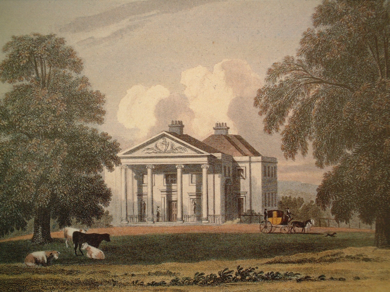
1813 – Albemarle Cator (the first or elder) is born at Beckenham, J.B.Cator’s eldest son who will inherit the estates.
1816 – This map is said to be published in 1816, probably surveyed earlier in the 1799 OS. At 1 mile to the inch the lake is more of a curved canal shape than the kidney shape on later maps. See the 1833 estate map and the 1799 OS Survey drawing etc. Of some interest is the description in J.P.Neale's publication of prints of the houses of the nobility and gentry which says the water through Beckenham Place is a tributary of the Ravensbourne and which had been widened (into a lake?). The old lake bed had a sluice and run-off channel which ran to the Ravensbourne. These days the stream from the viscinity of Foxgrove is mostly dried up. Also of interest on this map it shows the emparked land around the mansion and the blank or white area is part of the Foxgrove Farm lease. The enclose central part would appear to be the reserved woodland and probable pheasantry / shoot area.
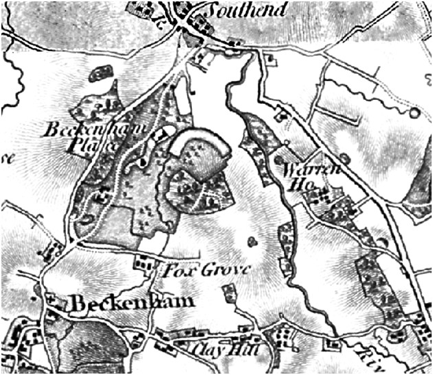
1817
– The London Courier and
Evening Gazette 09 June 1817 records a marriage of the daughter of
Mr Andrew Wedderburn of Beckenham Place implying an early lease of the
house to a tenant. If accurate this is the first record of leasing of
the house. Whether John Barwell Cator was leasing short term while in
Ireland or Woodbastwick is unknown.
1818 – Joseph Cator dies at Clockhouse. On 25th March, the College of Arms authorised to John (Barwell) Cator of Beckenham and Woodbastwick the Cator Arms, an earlier form of which can still be seen over the pediment at the front.(source: P.Manning). Joseph’s wife Diana dies in 1829 in Beckenham and whether she remained at Clockhouse is unknown.
1820
- Peter Burrell III of Langley, Lord Gwydyr dies and his Beckenham
estates at Kelsey and Langley are sold to new owners including the
Hoare Banking family and the Goodharts. (source: Bromley Historic
Collections and British Library). These estates are mostly south of the
Beckenham village whereas the Cator estates are mostly north of the
village. Burrell was MP for Boston, Lincolnshire and has an entry on
History of Parliament online. It was said the Burrells rose to fame by
not doing anything much i.e. Lord Gwydyr inherited one of his titles
from a great uncle, Merrik Burrell, and a high position through his
wife’s family. She was Baroness Willoughby de Eresby. The mainstream of
the family later changed its name to Drummond-Burrell and then to
Drummond-Willoughby. The title of Baron Gwydyr was passed to a cousin.
Wikipedia and History of Parliament are sources of information.
1821 – William Thornhill Cator is born at Beckenham Place, the younger of J.Barwell Cator's two sons. This evidences that the Cators were still occupying the mansion up to this time. At least for some of the time as Barwell spent some time in Ireland and Norfolk.
1823 – Anne Charlotte Cator born in Beckenham, daughter of J.B.Cator
1825 – John Barwell Cator and other trustees of the estate acquire permission via a private Act of Parliament to lease or sell plots of land for development on the Beckenham Estates. This is the beginning of a long process of disposal of the Beckenham estates which leads to the ‘remainder’ becoming the public park. John Cator's Will had put family trustees in place and restrictions on selling land. His will stipulated that his estate was for the use of John Barwell Cator with remainder to his heirs or assigns and the family were ‘remaindered’ in order of seniority. He also stipulated that leases should not exceed 21 years and that Beckenham Place would not be leased. No land was to be sold so an Act of Parliament was required to permit J.Barwell Cator and the trustees to dispose of or exchange lands. This extract explains that sales from the estate have to be matched by purchases of new lands either close to the Beckenham and Kent holdings or near Woodbastwick. John Barwell Cator is said to have sold land in Croydon to enable the purchase of more land in Norfolk:
“An Act to enable John Cator, Esquire to grant building leases of lands in the counties of Kent, Surrey, Essex and Hereford; and also for vesting in Trustees for sale part of the Estates in said Counties devised by the will of John Cator Esquire, deceased, and for laying out the money arising from such Sales respectively, under the Direction of the High Court of Chancery, in the Purchase of other estates, to be settled to the same Uses; and for other purposes. Schedule 1 includes particulars of property purchased prior to and after the death of Cator.”
The intention was that the ‘estate’ remained intact for the family at least in value if not geographically fixed.
The petition on the Act was signed by John Barwell Cator, William Cator, Bertie Cornelius Cator, Sarah Cator, Thomas Cator, Charles Cator and Peter Cator. These were the surviving children of Joseph Cator. It is interesting that this Act is not sought until after the death of Joseph Cator in 1818.
The papers of Mother Mary Baptist (formerly Bessie Taylor) for her 1967 thesis include the transcript of the properties covered by the Act. It illuminates the extent of the Cator properties in Beckenham and the section for “Additional Information” will include more details from the Act. Pat Manning also acquired copies of the property schedules in the act from the House of Lords archive. The schedules list fields, acreages, tenants and rents. Several locations can be identified from old Ordnance Survey maps, for example, the Addington properties are located around what is now New Addington at Lodge Lane and Castle Hill. Some descriptions are vague and cannot be accurately located ie. Mansion in the Parish of Battersea with meadows.
A
reason cited for the application or petition for the Act was that there
had been built development around the edges of the estate thereby make
development of the estate advantageous. A similar reason was given by
the Burrells and Raymonds in 1759 for seeking to develop parts of their
estates probably around the edges of Bromley and Beckenham towns.
Briefly, the estate was in Beckenham (1108 acres),
Carshalton (12 acres), Croydon (about 560 acres), Addington, Chelsham
and Farleigh (over 1100 acres), Ross, Herefordshire (only 9 acres),
Chingford, Loughton and Waltham Abbey (about 140 acres), Bromley (about
25 acres), Lewisham (about 95 acres/ at Wricklemarsh and/or Sydenham),
Chittenden Farm at Chiddingston and Hever in Kent (193 acres), Penge
(55 acres before Cator’s death, 176 acres purchased after his death),
Leigh Park Farm and Priory Farm, at Leigh, Kent (280 acres).
Wricklemarsh isn’t separately identified and whether it is included in
the Lewisham figure or disposed of already is unclear. Of note is the
land in Penge acquired after John’s death in 1806 which Pat Manning
attributes to Joseph Cator. References to the Cator involvement in
Penge Common enclosures can be found and also involvement with the
Croydon Canal company. I was surprised to see that land in Ross was
only 9 acres compared to the extent of the other estates.
Penge
is described as at least partly in the Parish of Battersea which might
subsequently come under Beckenham in the tithe map.
Very
little can be discovered regarding some of these properties. In the
1840 Tithe Map of Kent, payments were made for Chittenden Farm at Hever
by owners John and Samuel Williams and occupied by John Norman and for
Leigh Park Farm and Priory Farm at Leigh the owner is shown as Lord de
Lisle with James Bellingham as occupant/tenant. Cator's business
dealings were such that it is possible he held mortgages on these
properties but we have to await a lucky break to discover the full
story.
John Barwell Cator subsequently was widely referred to as just 'John Cator' which leads to some confusion over estate affairs and attribution of some developments to the wrong 'John'. The given names of the Cator 'landlords' alternate between ‘John’ and ‘Albemarle’ but John (Barwell) Cator was succeeded by his son Albemarle (1813-1868), who's first son John died before inheriting the estates so the second son also named Albemarle (1836-1906) inherited. His son John (1862-1944) followed but he broke tradition and had a son named Henry (1897-1965) who then returned to tradition having a son John (1926-1999) who's son Albemarle (1953-present) is the current holder of the remaining estates in Woodbastwick at time of writing (2019).
1826
- The British Press of 22nd July carries an advertisement for the sale
by auction of three farms listed in Cator's properties in the 1825 Act
of Parliament. We only have the information in the Act, the
advertisement for sale of Chittenden Farm in 1788 and this
advertisement for sale of the three farms. Chittenden Farm near
Hever, Leigh Park Farm and Priory Farm near Leigh (near
Tonbridge, Kent). Chittenden Farm 193 acres, Leigh Park Farm 152 acres
and Priory Farm 130 acres. These acreages match those recorded in the
Act of Parliament and the fact that the Act records the intention to
sell those properties for reinvestment elsewhere (ie Woodbastwick,
Norfolk).
1827 – The Morning Post of 16 August 1827 records that the daughter of James West of Beckenham Place and Bryanston Square marries Charles Wyndham Rawdon in Beckenham Church.
1828 – The Cators acquire Kent House Farm bordering Penge Common from Alexander and Thomas Baring (National Archive and Lewisham Local Studies) Indenture regarding title to Kent House Farm.
1828 – W.H.Ireland publishes his New and Complete History of Kent drawing on previous publications by Philipott, Hasted and Lysons. He describes the Manor of Foxgrove becoming divided in the 1700’s in three parts which I assume to be Raymond and the Burrell’s, Cator, and Bolingbroke. He describes Beckenham Place Park being embellished with infinite taste by its affluent proprietor (John Barwell Cator).
1828 - London Evening Standard 29 September 1828 records David Inglis from Tunbridge Wells for Beckenham Place. Newspaper small ads published change of address and movements of people (social media of the day).
1829 - Alexander D. Inglis recorded as tenant of the Mansion in the Morning Post 22 August 1829. Pat Manning reports that the Cator family believe J.Barwell Cator occupied the mansion up to 1841 but these other tenants cast some doubt on it. It’s entirely possible that J.Barwell Cator leased the mansion during periods when he was resident in Ireland or Woodbastwick, Norfolk.
1830 - Foxgrove Manor house is demolished and a new farm house built. (source: Rob Copeland)
1831 – The Kentish Weekly Post records a daughter born to the wife of Alexander Inglis at Beckenham Place. The Inglis’s leave by 1834.
1833 - An estate plan is produced: Map entitled: 'Plan of an Estate belonging to John (Barwell) Cator Esq situate in the Parishes of Beckenham, Lewisham and Bromley in the County of Kent'. Shows roads, field boundaries, Southend, parish boundaries (with Croydon and Penge) and boundary with Lord Farnborough's lands. Scale is 5 1/2 cm: 1/4 mile. Certified as 'Plan marked B3' in declaration of Thomas Henry Burroughes and John Cator (Bromley Library).
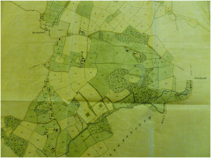
Reproduced courtesy of Bromley Historic Collections
This extract from the map raises some questions as a subsequent estate plan says that shaded areas are on long leases to tenants so probably the same is true of this one. It is frustrating that any accompanying documents are not with the map which would have given field names and leaseholders. I assume unnumbered fields or buildings are not Cator property but illustrated for mapping detail, and perhaps seen as potential purchases? Although Barwell Cator was decamping to Norfolk the family were still dealing in this area as evidenced by documents concerning the Croydon Canal and Penge Common. Comparison with the Foxgrove plan and Beckenham Manor plan shows that field patterns changed and the River Pool was straightened for some of its course. Maybe some leaseholds can be identified from the descriptions in the 1825 Act of Parliament document. The map is orientated with West at the top and does illustrate how the Cator land was mainly to the north of the village. Even so there are plots belonging to others. S.Wilson Esq having some of the north side of the High Street including plots which had been Cator’s on the 1776 Foxgrove plan and G.Austin has the area around Thayers Farm north of Clockhouse. G. Austin is probably an heir of Francis Motley Austin found on the 1809 Burrell map. Lord Farnborough to the east of Cator’s land had the estate around what is now Bromley Court Hotel.
1834 – Launcelot Holland is recorded as tenant of Beckenham Place in the South Eastern Gazette 21 January 1834 when his daughter marries Charles Manners Forster, son of John Forster of Southend. Launcelot Holland would later be tenant or occupant of Langley Farm in the 1841 census living on independent means. Martha Cator, daughter of Peter Cator, marries Henry Holland, Launcelot’s son, in 1841 so there are family ties and associations.
1835 – John Cator (1835-1859), eldest son of Albemarle Cator the elder is born but will not survive to inherit the estates, he dies in 1859 of wounds received in the Crimea. His birth date is subject of some speculation as the family may have been in Ireland at the time of his birth. Two siblings were born in Ireland but his younger brother Albemarle who does inherit, was born at Woodbastwick. This evidences that the Cators were mainly absent from Beckenham around this time. John Barwell Cator, the father/grandfather was also in Ireland very often at this time. (source: P.Manning and census evidence)
1835 - Mr Peters. a banker is tenant of Beckenham Place. Whether some shading of the estate map reflects his lease is unclear. Peters was succeeded by Captain Walter Raleigh Gilbert, R.H.A., no dates available. Followed by R.H. Page who later changed his name to Page‑Henderson. Although census records note the occupants of the village there are not addresses in the first records. Later census records give addresses and eventually occupiers complete their own census returns.
1835 – These details relate to sales of parts of the Beckenham and Penge Cator estates. Bromley archive has this document relating to Penge Place and Farm which will become Crystal Palace Park: John (Barwell) Cator Albemarle Cator Thomas Mason of Linden grove, Bayswater, Middlesex, Surveyor (2) John Scott of New Broad street, London, Esquire Property: Mansion House, stable and grounds called Penge Place, lately in the occupation of Henry Peters, Esquire. Also Penge Cottage, farmyard and stables, lately in the possession of Joseph Rose. Also 93 acres, 3 roods and 24 perches of land in the occupation of Peters, Rose and William Wilmot, all as tenants. Also Upper Barn Field, the Grove, part of Upper Wood, part of Hermitage Wood, part of Windmill Hill Field, Three Gate Field, Holly, Rag Field, Six Acre Field, Shoulder of Mutton Field, Nine Acres, Five Acre Field, Coal Earth Field and Filbert Orchard. All in Penge, Battersea, Surrey. Terms: 1st parties bargain and sell to the 2nd party, to hold for a year, at the rent of a peppercorn. (b) Attested Copy Conveyance Parties: (1) Bertie Cornelius Cator and John Foakes(2) John Cator(3) Albemarle Cator(4) Thomas Allason (owner of lots 5,6,23,24,25)(5) John Scott(6) George Grote Property: As above Consideration: £11,750 14s 6dTerms: 1st and 2nd parties release Penge Place to Scott, Grote as trustee
Also in 1835 The Crooked Billet public house, Penge Wharf and several other properties are offered for freehold sale in three newspapers. As the Crooked Billet and other Penge property had been in Cator possession it is almost certain these sales were by John Barwell Cator. Penge Wharf is recorded as being part of George Wythes property at a later date and it is known that George Wythes bought a lot of Cator property and subsequently developed it. One reason why my view is that the Cators were not the development and planning activists as some believe. Penge Wharf is purchased by John Lawrie of Sydenham Place. Lease and release was a form of land sale made to avoid tax, later made illegal.
|
14/15 October 1835 |
|
(a) Lease |
1836 - Albemarle Cator II is born at Woodbastwick, Norfolk. The family return to Ireland where subsequent siblings are born until about 1844 according to census evidence his sister Charlotte is born in 1838 in Ireland. With Albemarle’s wife’s family being in Ireland it is possible they travelled back and forth if she felt more comfortable going into labour near her family.
This
is also the year of a great storm, from The Evening Chronicle 02
December 1836 "The storm of Tuesday morning raged here with great
violence. In Langley Park above 100 trees have been uprooted. In
Kelsey, Eden Farm and Beckenham Place forest trees of the largest
dimensions are lying in all directions.
1837 – John Barwell Cator puts some property up for sale in the County Chronicle, Surrey Herald and Weekly Advertiser for Kent 25 July 1837 page 2 col 170 acres on Penge Common and 15 acres more, Shortlands House and 56 acres with Lodge Farm 75 acres, Norwood and Penge Common 40 acres, 50 acres and 42 acres, Oakery 9 acres, adj (Mr Scott) 23 acres, adj 9 acres, adj 1 acre.
1838
- The Tithe map and returns show William Peters in occupation of
Beckenham Place, the house, lodges and 71 acres of land. But some
fields and woods known to be part of the current park are held 'in
hand' by
John Barwell Cator and William Gibbons who is shown as
occupying Foxgrove Farm also occupies parts of Beckenham Place Park
such as
the woodland and what is now called Crab Hill but was earlier called
Thistle Down.
Crab Hill road appears to have got its name from a field of Foxgrove
Farm called Crab Tree Field which is outside the park. Somehow Thistle
Down became forgotten and Crab Hill adopted as the name for this part
of the park. The Tithe list of land and values shows William Cator
owning or at
least having part of Beckenham in his name perhaps as a trustee of the
Cator estates. We believe we have evidence
of the Cators having an interest in land in Essex up until the 1838
Tithe map around Woodford but that is being researched.
Thayers
Farm next to Clockhouse is 'owned' by Albemarle Cator the
first, the eldest son of John Barwell Cator, and occupied by William
Inglis comprising of 45 acres. Clockhouse with its Stables and gardens
is owned by John(Barwell)Cator but unoccupied. William Cator has 194
acres on the Anerley/Penge borders including what would be the site
Beckenham Cemetary occupied by William Rogers. The Tithe for
Lewisham which covers the north and eastern parts of the park was
somewhat later in 1843 and shows that William Peters only had the
stable block and a small paddock whereas much of the arable,
wood, lake, pasture and plantation was 'in hand' with John
Barwell Cator. William Gibbons had on lease from Cator a mill, millpond
and small fields
at Southend.
The
Cators had about 300 acres in Lewisham around the park and elsewhere.
In Beckenham they had 1300 acres. The remaining park is about 214 acres.
1841-51
– The 1841 and 1851 census show William Peters of Beckenham Place and
in 1848 his daughter Marianne marries Captain Walter Raleigh Gilbert.
Recorded in Western Times 30 December 1848
This
evidences, with the 1838 Tithe Map, the length of the Peters
lease of the house which was
hitherto unknown. See 1835 which states that Walter Raleigh Gilbert
takes over residence. Other press announcements evidence the Peter’s
residence at Beckenham but also intimate a seasonal movement between
Beckenham and other residences i.e. Brighton Gazette 03 April 1845 Mrs Peters and family have left
Regency House for Beckenham Place and Sussex Advertiser 28 March 1848 Mrs Peters has left Brunswick
Terrace for Beckenham Place.
In
the 1841 census Foxgrove Farm is shown as occupied by William Gibbons,
Farmer with
family members and farm labourers.
There
is no census record of the Cators for Beckenham or Woodbastwick as the
family is believed to be in Ireland. John Barwell Cator’s wife’s family
was in Ireland and though his son Albemarle was born in Beckenham,
Albemarle had children born in Ireland by his wife who was born in
Abbot Dangan, Ireland. By the 1851 census Albemarle had become
established in Woodbastwick with three children upto the age of 7 born
at Woodbastwick.
1847 – Elizabeth Louisa Cator nee Mahon dies at Hessen in Germany. It is said that John and Elizabeth were living in Germany to economise on living expenses. Whether true or not requires confirmation.
1851
to 1873 - Peter Cator, brother of John Barwell Cator, is living at The
Hall, Bromley Road, Beckenham.
He is recorded as managing the Cator estate locally after spending
several years in Madras. (sources: census, Manning and BHS). The 1851
census shows Albemarle Cator, the eventual figurehead of the estates
living at
Woodbastwick and all his children are born in Ireland or Norfolk. He
will inherit in 1858 on the death of his father.
1853 – Rob Copeland records in his Manors of Beckenham that occupation of Foxgrove Farm passes from William Gibbons to his son Henry Gibbons. Whether as freeholders or under lease we don’t know but probably under lease. A later estate record in Bromley Collections may explain. But the 1857 electoral roll lists William Gibbons in occupation. The 1851 census shows William as head and Henry as farm bailiff. From an OS map of about that time we might deduce where the Foxgrove Farm and Beckenham Place boundaries met. Parkland was shaded and other fields in plain white.
1857 - John Clairmont Abrams in occupation at the mansion (Pat Manning source) from an electoral roll.
1858
- John Barwell Cator dies at Woodbastwick Hall, Norfolk and the estates
are inherited by his son Albermarle (1813-1868). Albermarle will
eventually be succeeded by his 2nd son also named Albemarle. Pat
Manning records that J.B.Cator and his wife lived in Germany for some
time to save money. Though he had great wealth the restrictions on
disposing of the net worth of the estate seem to have caught up with
him and there are several opinions that he was extravagant. His effects
are valued at under £35,000 but this may be just personal assets apart
from estates left in trust which were still extensive at Woodbastwick
and Beckenham as the estate map of 1864 updated to 1889 shows. It
requires deeper investigation but we know that physical assets in trust
and personal cash can be quite different matters.
1861 - Robert Henry Page and family reside in the mansion. A Merchant and Russia Broker. (source U.K.census 1861)
1864
- November, a map of the Beckenham Estate of Albemarle Cator is printed
(Bromley Library Historic Collections). It excludes the site of Old
Manor House opposite the church as that is part of the Burrell estate.
That map shows a proposed road extending Westgate Road into Summerhouse
Wood and illustrates the intention of the Cators to build on or
sell/lease the land. The legend also states ‘revised upto 1889’
indicating that this is a later publication. It is also annotated as
being part of documents lodged with a commissioner for oaths in 1906
when the second Albemarle dies and his eldest son John Cator 1862-1944
inherits.
However
the map is also annotated "updated to 1889" so I list there in the
timeline.
1866 - The Mansion occupier is still given as Robert Henry Page Esq. (source: a directory found be E.Inman)
1868 - Albermarle Cator (the first) dies, Albermarle's eldest son John did not marry, dying without issue as they term it in 1859, hence Albermarle's second son, Albemarle junior (or the second) (1836-1906) inherited the estates (source: P.Manning). John had lost an arm due to injuries received in the Crimean War.
1868 – The Parish of Beckenham installs boundary posts, some of which can be found across the park. See 1884 for Lewisham boundary posts. (dates need confirmation)
1869/71 – The mansion occupier is Sir John Kirkland, Bart. J.P. an army agent who had good relations with Queen Victoria and Prince Albert and received gifts from them but he dies in 1871 prior to the census. He is associated with Blackfen and is referred to on a relevant website. A press advert gave an indication of Kirklands activities at Beckenham Place as it lists furniture, farm stock and produce to be sold after his death.
1870
- The first publication of the Ordnance Survey maps shows very
little built development around the park. Field patterns from the
Foxgrove and Beckenham manor plans may be detected. The Ordnance Survey
maps of the 1860's and 1890's in the British Library and National
Library of Scotland illustrate the mainly rural nature of the estates
at Beckenham and Blackheath. An internet search for 'NLS Kent VII'
should access the full map from which the extract below is taken. We
might assume that John Barwell Cator made changes to the estate as the
lake is of a quite different outline to the 1799 Ordnance Survey
drawing and comparing the two maps shows the difference in the
footprint of the house ie with a portico on this map, without on the
1799 drawing.
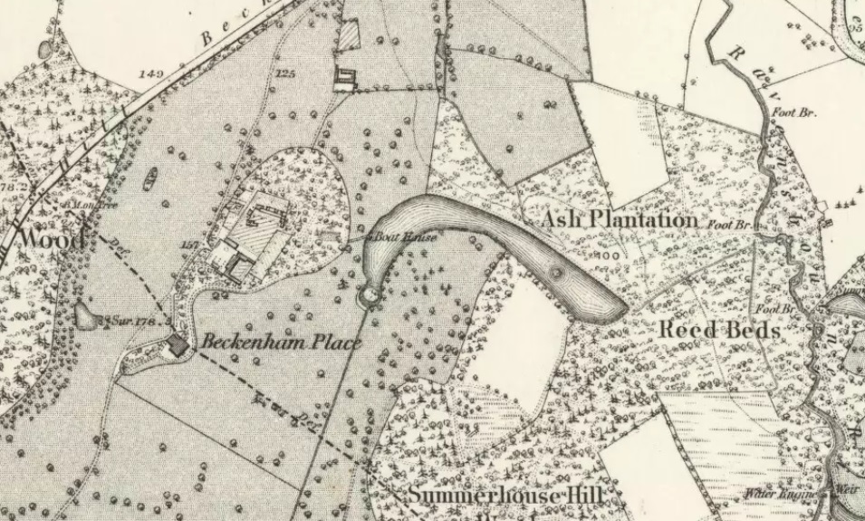
OS
map – National Library of Scotland (their website has access to many
digitized maps)
1871
- John Kirkland the younger is mansion occupant in the 1871 census with
son, aunt and servants. Albemarle Cator and family are resident at
Trewsbury House, Coates, Gloucestershire which they favour over
Woodbastwick which is also leased to other occupants. The lease must
have been vacated as a press advert puts the lease up for sale.
1873 - Peter Cator, youngest son of Joseph Cator, dies. He had lived at The Hall, Bromley Road, Beckenham and is credited with administering the Beckenham estates for some time. By the 1881 census The Hall is one of the Cator properties leased, in this case to Henry Phillipps a merchant who came from Padstow.
Charles Oliver Frederick Cator,1837- 1876 Inventor of the Leverage Anemometer. Author of various papers on meteorology. Son of the late Lady Louisa Cator and Rev. Thomas Cator. Succeeded to the entire management of the Cator Estate in 1873, when his uncle, Peter Cator died.
Obituary Beckenham Journal (monthly bound volumes) January 1877, 10, 20 (Bromley Historic Collections)
1874‑6 John Fell Christie is listed in a directory.
1875
– This record looks like it relates to at least some of the disposal of
the southern part of the park, being on the north side of Foxgrove
Road:
Bromley
Library archive: Agreement between Albemarle Cator of Woodbastock Hall, Norfolk,
esquire (1st part) and William Henry Maltby of Beckenham, Kent, builder
(2nd part) in relation to 2 pieces of ground on the north and south
sides of Foxgrove
Road, Beckenham. Cator agrees
to let the property to Maltby for 90 years at the annual rent of £10
per year for the first year and £40 thereafter. Maltby is to build a
dwelling House. Includes a map of the premises and draft form of lease.
A
large house in a large site was built called ‘Foxgrove’, not to be
confused with Foxgrove Farm. Foxgrove Avenue is now on the site.
1877‑8 No one is listed as in occupation of the mansion. Albemarle Cator the younger, second son of Albemarle the elder is born at Coates, Gloucestershire. He will inherit the estates as his brother John does not survive to inherit.
1878 – Foxgrove Farm demolished (source: RHCopeland)
Foxgrove Farm shortly before demolition
1879 - Spencer Brunton and his family are in occupation of the mansion. The Brunton children made a story book Christmas card depicting a royal family visit, maybe this harks back to the Kirkland residency or is just children’s imagination. This page from the book depicts a move into the mansion. But by 1881 they are in the census as living at Brook Street, London with their 6 children and a string of about 10 servants including a butler and two footmen. Spencer was a member of the London Stock Exchange but by 1891 his wife had filed for divorce. An earlier 1871 census shows they had lived in Copers Cope Road at a house called The Ferns with a daughter and only 3 servants. The six children were born in quick succession.
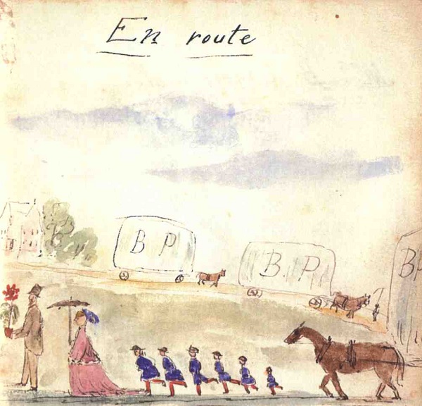
1881
- The census shows the mansion is occupied by Owen Henley aged 32 and
family, a gardener
- so we might assume he is acting as gardener/caretaker. Unless of
course the official tenant is just absent and recorded at another
address?
In
the census for this year Albemarle Cator is recorded as being at
Trewsbury House, Coates, Cirencester with his wife, 12 children and a
string of servants.
Spencer Brunton had moved to Brook Street,
Westminster. We find Owen Henley previously listed in 1871 aged 22
unmarried
living in St. George’s Villas, Beckenham as a domestic gardener,
But
1881 is also the year for this event in June:
This article was discovered by one of our ‘eagle–eyed Friends’ in the Local Studies library in Bromley. It is from The Beckenham Journal. JUNE 1881.
BAZAAR AT BECKENHAM PLACE.
On Saturday and Monday last, the 25th and 27th June (1881), a grand bazaar was held in Beckenham Place, which was kindly lent for the purpose by Albemarle Cator Esq., the object being to aid in defraying the debt remaining on the Building Fund of St James' Church, School, and Working Men's Club, Elmer's End. The idea of the bazaar had been originated and carried into effect by a number of ladies desirous of assisting the church, whose efforts had been made quite apart from those of the Building Committee. They had secured influential patronage, H.R.H. Princess Mary Adelaide, Duchess of Teck, who had kindly promised to honour the bazaar with her presence, and to perform the opening ceremony, and of Viscount Lewisham, M.P., and Lady Lewisham, Major-General Lord Chelmsford, G C B and Lady Chelmsford, Right Hon. Lord Forbes, Hon. Lady Inglis, Hon. Mary Thesiger, Sir Charles Mills, Sir Edward Scott, Bart and Lady Scott, Co1. Sir John Farnaby Lennard, Bart., and Lady Lennard, Lady Cave, Lewis Loyd, Esq., and Mrs. Loyd, Mrs. George Lillie Craik, and Albemarle Cator, Esq. Great anxiety had been manifested to make the bazaar a success, the ladies who consented to take stalls, pledging themselves to provide stock to the value of at least £100, a sum which was unquestionably for exceeded in nearly every case. Consequently there was no lack for those who came, to use the words of Marzials' popular song, "With their pockets full o' money," to exercise their liberality in a good cause.
At Beckenham Place excellent arrangements had been made for accommodating the large number of visitors expected, and all that was necessary to render the occasion completely successful was fine weather. Unhappily Saturday proved unpropitious in this respect for rain fell during the greater part of the morning, at times very heavily, so that by two o'clock, the hour fixed for opening the grounds, every place was thoroughly wet. This misfortune necessitated the alterations of some of the arrangements by rendering any proceeding in the open air impossible. Thanks, however, to the care of those who had the arrangements in hand, no inconvenience was felt beyond that occasioned by the crowding of the rooms.
Shortly after three o'clock, Princess Mary arrived, accompanied by her daughter, Princess May, and her little son, Prince Randolph, and attended by the Honorable Mary Thesiger. The Princess was received at the entrance of the fine old mansion by the Rev. A. Barber, Incumbent of St. James', Lady Inglis, Lord Chelmsford, G.C.B., Albemarle Cator, Esq., Mrs. A. Cator, and Rev. W. Cator. Having declared the bazaar open, the Princess proceeded to inspect the stalls. In the apartment on the left of the entrance hall were three stalls, the first held by Lady Inglis, the Misses Inglis, and Miss Buckworth; the second by Mrs. Barber, Mrs. PascalI, Mrs.Strickland, and Miss Isaacson; and the third by Mrs. Wallace and family, assisted by Mrs. Phillips. Each of these stalls was well stocked with the thousand-and-one articles always provided for such occasions, Lady Inglis’ being arranged as effectively, perhaps, as ,any in the bazaar. Mrs. Barber's stall, the goods on which were valued at upwards of £250, contained a number of contributions from working men and women, who had devoted their spare time of some months past to their production. A room on the other side of the building contained stalls kept by Mrs. and Miss Kirby, and by Mrs. W. C. Jones, Mrs. Green, and Miss Smart. The latter stall was stocked to a large extent with fancy stationery and kindred articles, amongst them being some beautiful views taken by instantaneous photography. There was also a collection of New Zealand native spears and other arms, which soon secured purchasers. A spacious apartment, arranged in a most enticing manner, was devoted to refreshments, which were dispensed by a number of ladies under the direction of Mrs. Cameron and Mrs. Bicknell. Further provision in the way of creature comforts was made by Mr. Cameron, who had furnished a first-rate cold collation. The most attractive stall, at any rate in appearance, was that for flowers and fruit, which occupied a room by itself, presided over by Mrs. Radcliffe, Mrs. Blundell, Mrs. Newcombe, Miss Burleigh, and Miss Jones. These ladies had furnished themselves with a stock of choice flowers and fruit, which they had arranged so artistically that it was not at all surprising to find that the Duchess of Teck spent some little time there - indeed there was no department more worthy of a visit than this. Upstairs, Dr. Phillips had a number of microscopes, with some most interesting and instructive slides, on view; while Mr. Bloken was in charge of a Fine Art Collection, which preferred no claim to be considered "aesthetical." Another item calling for notice is that sketches of the new church of St. James, which has been designed by Mr. .A. R. Stenning and will be a very handsome structure, were on view.
Her Royal Highness, having completed her tour of the stalls and made several purchases, proceeded to a concert room, where some of the pupils of the Royal Normal College and Academy of Music for the Blind, Upper Norwood, were about to give selection of music. Mr. F. J. Campbell, the Principal, having been introduced to the Princess, who referred to the affection entertained for him by his late pupil, Prince Alexander of Hesse, the following pieces were performed, by Her Royal Highness' request :-Humerous glee, "Humpty Dumpty sat on a wall" (Caldicott); song, "Die beiden Grandieri" (Schumann), Mr J. Prydie; trio," O Memory" (Leslie), Miss A. Campbell, Miss A. Carson, and Mr A. Hughes; piano solo, " Silver Spring," by W. Mason, a lad aged 14; and the humorous glee, "Little Jack Horner" (Caldicott.) All these pieces were performed with that skill and effect for which the members of the College are justly renowned, and they secured the hearty applause of the Duchess.
Her Royal Highness left soon afterwards, to the strains of the "National Anthem."
During the afternoon a very large number of persons visited the bazaar. A brisk trade was carried on at the different stalls, and there were several canvasers for subscriptions towards articles to be drawn for. A second selection of music was given by the Blind College, and the Band of the Royal Artillery, which was present under the conductorship of the Band Master, Mr. Albert Mansfield, also provided some most enjoyable music.
In the evening a Promenade Concert was given under the direction of Mr F. T. Newcombe at which the following ladies and gentleman took part:-Mrs. PascalI, Mrs. Newcombe, Mrs. Radcliffe, Misses Brown, Miss Wigan, (an exceedingly good performer), Miss Burleigh, Mr. M. Beaumont, Mr. Sternhardt, Mr. Weber, Mr. A. H. Neuffert.
On Monday there was a very large attendance. The proceedings were enlivened by the band of the Duke of York's School. The total receipts of the two days amounts to over £750, which sum, after paying all expenses, provides the Ladies Committee sufficient to pay off the debt on the building fund, and a balance of £50 for other purposes.
1880 - This passage was taken from The Beckenham Journal and Penge and Sydenham Advertiser, JUNE 1880. Copies of these journals are in the Local Studies library in the Central Library in Bromley.
The
area referred to is not clear, the Friends would be please to hear
ideas on the location mentioned. Perhaps Cator Park, Kings Hall Road?
‘NOTES BY THE WAY’.
We have mentioned that a proposal has been made on behalf of Mr. Albermarle Cator to let on lease 42 acres of land for 99 years to the Local Board, to be appropriated as a recreation ground. The exact terms and covenants are not stated, but we believe they are liberal. The Board have applied for a statement of the conditions, and are favourably disposed to its consideration. The main difficulty is that which meets the Board at every point-that however moderate the terms, there will be some cost incurred, and with the many claims upon the rates for the execution of absolutely necessary works, there is much hesitation in entering upon others, however desirable, that will lay the slightest burden on the ratepayers. The ways and means are always approached with caution, and discussed with anxious care. It will always be the case that in a scattered district the expenses will be heavy and appear out of proportion when compared with compact and covered districts. We observe that about one-fifth of the amount collected is spent upon lighting and upon watering and repairing the roads, and these items of expense would not be greatly increased if the houses were much more numerous. The rating value of the neighbourhood in such case would be increased, and the expenses would appear lighter. We feel bound to say so much, when such a proposal is before the Local Board; but, at the same time, we should deeply regret if such a favourable opportunity of obtaining a recreation ground of' suitable extent and in perpetuity is lost. The opportunity may never occur again, if allowed to pass away. We are aware another pressing matter is before the Board; that of obtaining a burial ground. We think that the leading ratepayers ought to assist, and there is one way of doing so that at once occurs to us. If the Cricket Club would unite in any way, the case might be met. No doubt the money required for laying out the grounds for such a purpose might be borrowed upon a long term, so that it really would be little more than the interest that would fall upon the ratepayers. We trust that the proposal of Mr Cator will not only be a liberal, but a generous one, and that the Board will be strengthened by the public approval to enter upon the undertaking.
1882 – A lease on a site called Hawthorndeans abutting Southend Road for 90 years, presumed to have been made freehold at a later date. A large house on a sizeable plot.
1883 – About this time a Beckenham directory records that the installation of the West Kent sewer caused the drying up of the moat around Foxgrove Farm. This area supplied the water for Beckenham Place’s lake so I’m concluding it was this that was the main cause of the lake subsequently drying up.
1884? – The Boundary posts are installed between Beckenham and Lewisham parishes. Robert Borrowman's book from 1910 records the ceremony of Beating the Bounds from parish records, but that the parish boundaries had become lost or forgotten so a sum of money was made available and cast iron boundary posts installed to mark the parish boundaries. Several of these posts are in Beckenham Place Park marked 'Beckenham' along with some marked 'Lewisham'. The parish, or now Borough, boundary has since been moved. Some posts are near old oak trees which for many years or even centuries were used as boundary markers. Some old maps record 'boundary mark on tree'. One interesting speculation or story is that the Beckenham parish boundary is strangely shaped as a body was found near Crystal Palace but no parish claimed it for burial apart from Beckenham so the boundary was drawn to where the body was discovered. Now boundaries are more 'political' and determined by the Boundaries Commission.
One
curiosity is perhaps that Foxgrove Manor seems to have been partly in
Beckenham Parish and a small part in Lewisham Parish as well as Bromley
Parish. As Borrowman
records that the Parish boundaries were forgotten perhaps the ancient
parish boundary was more to the north than it was fixed in 1884. The
Cator estate plan revised to 1889 shows a disputed boundary near the
mansion. It would be interesting to see if these historic markers
survive the park remodelling.
1885 - A Beckenham directory published by Thornton’s contains a brief history and informative data. Despite much of the information being presumably correct and quoted from sources I use in this account, some information is mixed up. For example in the passage below Beckenham Place was not the home of Piercy Brett, he lived at Clockhouse. And as I state here, Beckenham Place was in Foxgrove Manor and not in the 1773 Beckenham Manor property. This directory describes the water for the moat of Foxgrove being lost when the West Kent main sewer was installed.
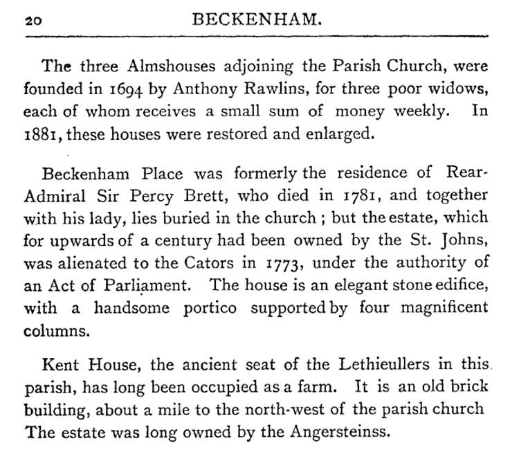
1885 – From a local directory: The populatiop of Beckenham continues steadily on the increase. In 1871, the census recorded a population of 2391, in 1861, it was 6090, showing an increase of 3699 in ten years, and during the following period of ten years, there was a further increase of 6,921, making the total in 1881, 13,OII. The population is now estimated at 15,000, equal to that of Bromley at the last census. With this increase of numbers, much of the rustic beauty of the place has fallen a prey to the builder, and to the necessities of increased traffic and widened roads. The approach to the village, from Penge, not many years ago,wound through a splendid avenue of trees; Bromley road has been changed from a shady to an open thoroughfare; and last, but far from least, Church hill has been deprived of that wealth of wood and foliage which in past years made it a perfect picture. Whilst regretting the loss of so much that was beautiful, we cannot forget that we are living in a practical age, in which there seems to be no standing still, and with which few suburbs are going more rapidly or successfully forward than favoured Beckenham.
1885‑93 Edwin Covell lives in the mansion, a butcher’s proprietor/meat salesman. An 1885 directory has an advertisement for his business. The Bromley Record reports his death in May 1893 and his obituary states “he was the largest importer of foreign cattle, farmed extensive land in and around Beckenham” Another Covell family occupies Kent House Farm as farmers presumably also as leaseholders. The Covells are recorded on the 1891 census along with several servants. Study of the census records reveals the number of people ‘in service’ and ‘living in’ in the large villas of the viscinity.
1889 – We should revisit the 1864 Estate Plan annotated as ‘revised up to 1889’ as the plan shows areas leased in several cases to developers. Although this is the plan which shows an intention to have a road through Summerhouse Wood the plan predates the coming of the railway, its route is not even indicated on the plan but the map might be the basis for planning the railway which is authorized by an Act of Parliament in 1889.
Looking at the areas outside the park on the map it shows that very little development has taken place in Beckenham, Lewisham and Bromley. The OS map shows development near to Beckenham village, mainly large Victorian villas. The census returns for the period illustrate large households often with servants occupying coach houses, some houses used as schools, and often accommodating what is referred to as ‘professionals’. Of course there are some artisan housing areas of terraced property near the village centre. The records of the estates of the Wythes and Hoare families illustrate the nature of property leasing and development. Again searching online catalogues of Bromley Historic Collections is informative.
The legend of this map states that land coloured pink is on long lease to leaseholders and that roads made and now being made coloured brown whereas intended roads are outlined. The landlord reserves the right to alter omit or substitute other roads. What is now The Avenue is called Mote Road (after the moated Foxgrove Farm/Manor). Leased property can be seen in the southern corner of what was the original park. This is perhaps the cusp upon which the existence of the current public park is turned. Copers Cope Road, Brackley, Worsley Bridge, Park Road seem to bear the brunt of development over the next years. The small area next to the mansion is shown as disputed parish boundary.
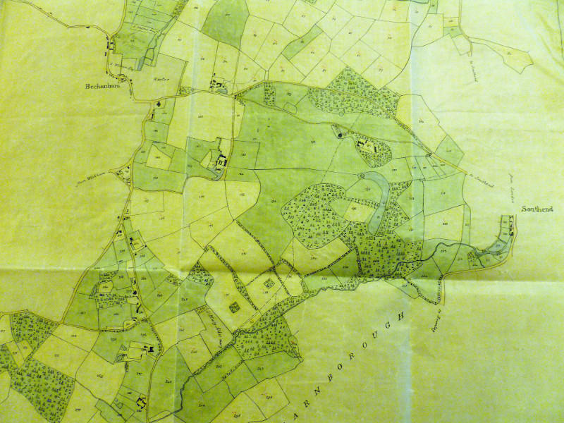
Estate Plan updated to 1889 – Courtesy of Bromley Historic Collections
1889 - An Act of Parliament authorises building of the Nunhead to Shortlands railway which runs via Beckenham Hill station to Ravensbourne station across the park. It states that Albermarle Cator is to be compensated for lands purchased etc. Negotiations began as early as 1884. The Cators had obtained parliamentary approval to develop their Beckenham estates for housing in the 1825 Act and the 1865 estate plans show an intended road slicing right through Summerhouse Hill Wood, a proposal which fortunately never materialised. In 1879 discussions took place between the Cators, neighbouring landowners and the London, Chatham and Dover Railway concerning a proposal to build a railway along the Ravensbourne valley in order to encourage speculative builders to construct houses in the area. This came to nought, as did a bill brought before Parliament in 1884. However in March 1889, an agreement was signed between Albemarle Cator of Woodbastwick Hall, Norfolk, Sir John Farnaby of Wickham Court and representatives of the London, Chatham & Dover Railway, which paved the way later the same year for the passing of an Act authorising the construction of the Shortlands and Nunhead Railway.The landowners contributed land as well as finance whilst the L.C.D.R. guaranteed to operate the line once it was constructed. Records in Bromley Library note the Forsters and a Mr Redman as being promoters of the bill to authorise the railway with compensations and land purchases from Albemarle Cator (jnr.).
05/07/1889 Agreement between Alfred George Renshaw, of The Hall, Southend, Kent, esquire and William Stewart Forster, of 28 Lincolns Inn Fields, esquire, promoters of the Bill relating to the Incorporation of the Shortlands and Nunhead Railway Company (1st part) and Albemarle Cator, of Woodbastwick Hall, Norfolk, esquire (2nd part). It is agreed between the parties that if the Bill is passed in to law to authorise the construction of the railway, then the Company erect stations at Ravensbourne and Beckenham Hill and will pay compensation to Cator. Cator will sell property to the Company as required. (source: Bromley local studies)
The attraction for the railway company was that it offered an alternative route to that through the Penge tunnel, an important role it provides to this day. Maximum charges per mile were set at 3d, 2d & 1d for first, second and third class passengers, 4d for horses, 1d for cats and dogs and 5d or 4d for carts and carriages depending on whether they had two or four wheels. Five stations were to be provided on sites selected by the landowners, each well staffed and provided with all comforts for both lady and gentleman passengers despite the fact that when they first opened they were surrounded by fields with hardly a dwelling within sight! As the landowners provided the lions share of the resources the precise route of the line was dictated by them, not by the operational needs of the railway company. The result is that the line winds its way along the valley carefully avoiding major features, such as the former lake in Beckenham Place Park as can be seen from the sketch plan which shows the original field boundaries.
The railway company was very happy with their new route, which cost £265,000 and opened for business on 1st July 1892. Under a new Act passed in 1896, they assumed complete control of the Shortlands & Nunhead Co exactly five years after it opened. Ravensbourne Avenue, Crab Hill, Downs Hill and Farnaby Road owe their existence to the building of the line, as does the gully, which forms the present entrance to the park from Crab Hill. This was said to be the source of much of the gravel used in the construction. Many of the trees, which still shield the line, are the successors of those originally planted to screen it from the expected housing development. This house building never took place, but evidence of the Cators' expectations can still be seen today.
The width of the bridge, now connecting nothing but two parts of the park, suggests that it was originally designed to take considerable traffic. It contrasts markedly with the two earlier ones nearby in Westgate and Downs Bridge Roads, which are much narrower as they were probably intended solely to provide farm access. Despite several changes of ownership the railway service through the park continues substantially unchanged. Ravensbourne station lost its goods yard in the 1960s and in 1986 the booking office was badly damaged by fire. It has been rebuilt in a sympathetic style and the remains of the porter’s accommodation can still be seen in its basement by peering through a gap in the wall. Beckenham Hill station is basically unchanged apart from the loss of the down side canopy which was removed in 1968. We believe there was also a goods depot at one time.
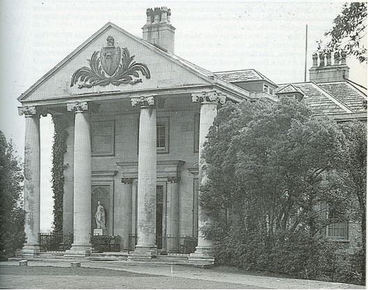
Beckenham Place circa 1892 – if accurately dated this photo shows the roof dormers installed prior to the house being used as a school or sanatorium.
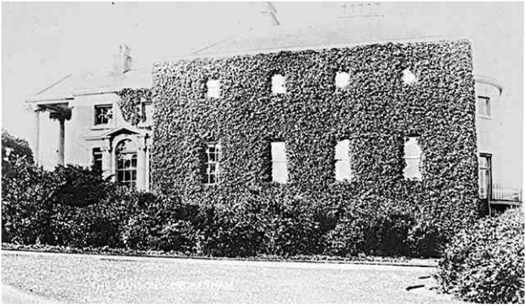
This earlier undated photo shows a roof without dormer windows, note the shrubs and ivy on the south wall.
1894 The Beckenham Place mansion occupier is listed as Mrs Covell, her husband Edwin has recently died in May 1893. E. Covell is also recorded as the tenant in the documents concerned with the authorisation of the construction of the Shortlands Nunhead railway through the estate. See also 1885
The Ordnance Survey map for 1894 below shows the road now called Beckenham Place Park and Westgate Road which partitions off part of the original park. Only a few houses have been built, St. Margaret’s which still exists, Maywood, Westgate and Fox Grove as well as some houses on Southend Road. The proposed extension of Westgate Road into Summerhouse Hill Wood from the 1833 estate plan has not taken place.
1895‑99 No one listed as in occupation of the mansion
1901 – The Bromley Record reports that the mansion is to be leased as a school and states “the news has given considerable satisfaction in the locality it being felt that the estate is now, at any rate for the time being, safe from the all-devouring speculative builder”. The mansion had been vacant for seven years.
1902 - Beckenham Place is listed as Craven College School. It had
always been difficult, especially as the area became increasingly
urban, to find tenants for Beckenham Place sufficiently wealthy to rent
both the house and the whole of the surrounding park. At the turn of
the century there was still a pheasantry in Summerhouse Hill Wood and a
photograph of the participants at the last shoot together with their
bag used to hang in the mansion. The local hunt last met in Beckenham
in 1905, by which time the house was occupied by a private boys school
called Craven College. An advertisement for which copied from
Thornton's 1902 Beckenham Directory by kind permission of Bromley
Library, is reproduced below.
The advertisement implies that the College was founded in the 1830s, but nothing is known of its early history or whether its name is derived from a place or a person. Immediately before coming to Beckenham it was only in Highgate for a few years, occupying a house in Millfield Lane on the north-east corner of Hampstead Heath.
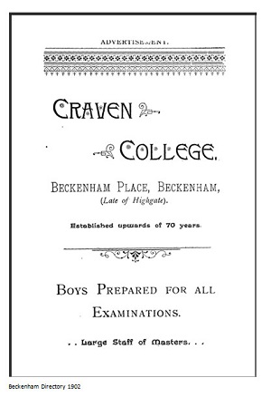
The College occupied Beckenham Place from approximately 1900 to 1905
under the headmastership of J. Hartley French. It then moved to Elmer
Lodge at Elmers End, possibly because of the loss of sports facilities
due to the lease of the park to the newly formed Foxgrove Golf Club.
Elmer
Lodge was built in 1856 on the site of a 17th century predecessor and
still exists today, substantially unchanged externally apart from the
loss of its conservatory. Today it is a mosque after many years
existing as a public house called appropriately ‘The Elmer Lodge’
J. Hartley French was succeeded as headmaster by Mr W.T. Carlin who
held the post initially assisted by a Mr E M Verall, until the demise
of the College at the outbreak of the 1914‑18 war. The existence of the
former college was commemorated by the nearby 1930s shopping parade,
known as "College Parade" until comparatively recently.
1906 to 1933 - From 1906 until 1933 Beckenham Place was the home of the Norwood Sanatorium which specialised in the voluntary treatment of wealthy(?) alcoholics and drug addicts. It was founded by a Dr Frances Hare, a retired Inspector of Hospitals for the Australian State of Queensland. The occupations of the patients in the 1911 census return is perhaps informative i.e. Medical practitioners and a chemist, a retired army officer, private means and an artist.
The reason for the name is probably because the sanatorium previously occupied a building at Crystal Palace, strictly speaking Upper Norwood, now called The Alma public house. The faint inscription 'Sans Souci’ still to be seen over the front door of the mansion is believed to date back to this sanatorium period or was imported with the stonework from Wricklemarsh in the late 18th or early 19th century.
The Conveyance of the park to the LCC in 1928 states that a lease was taken out on the Mansion on 1st of May 1906 for 21 years by Margaret Piper Rickman and later in 1925 the Norwood Sanatorium Limited took out or extended the lease for 7 years which would put the expiry into 1934. The implication here may be that Margaret Rickman sub-let or was acting on behalf of the Sanatorium.
Eric Inman relates: The sanatorium opened its doors on September 25th 1905 with 13 patients, a number which peaked at 232 in 1913. The average length of stay was six to eight weeks and the inclusive weekly charges pre‑war were £7.17s.6d a week, falling to £7.7s.0d after six weeks. This included medical attendance, medicines, board and lodging, games and ordinary services all provided in luxurious surroundings, as can be seen from the four interior pictures which are included by kind permission of Bromley Libraries.
The billiard and smoking rooms were reserved for gentlemen. The room to the left of the front door housing the current Visitor Centre is thought to be the billiard room. The drawing room was for the sole use of ladies, except when afternoon tea was taken there or gentlemen were invited for music or evening games. These could not last long for ‘lights out’ was at 10.30pm.
The sanatorium advertises its amenities as including, lawns for croquet, tennis and bowls. The home farm supplied fresh milk, new laid eggs and chickens for the table, whilst the hothouses and vegetable gardens provided fresh fruit and vegetables, including grapes, peaches and tomatoes.
Dr Hare retired in 1925 and died three years later at his home, 'Oakland's', 15 The Avenue, Beckenham. Kelly's Directory lists his successors as being Dr George (1926‑7), Dr Barham (1931) and Dr Given (1933). A Dr Walter Masters, who is not listed in the surviving editions of Kellys, is, in a detailed biography, described as taking over from Dr Hare before 1928 and moving the business to Chislehurst, because of a lack of space.
Doctor Hare authored several books on the treatment of addiction. We have accessed the 1911 census records which we reproduce here for illustration of the numbers of staff and patients present at Beckenham Place.
)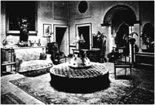
An interior of the mansion when a sanatorium
1906 - Albemarle Cator (II or jnr.) dies and is succeeded by his son
John Cator (1862-1944). It is under this John Cator that we presume the
park was sold to the London County Council. The various leases and
sales of other land is too complicated and lengthy to attempt to relate
here. A reminder that Pat Manning's book covers the Cator family in
some detail and researching the various online archive catalogues is
informative. Looking at the online catalogue of Bromley Local Studies
also reveals some basic details of land sales and development. The
estate plan of 1833 is annotated as being part of the Will documents of
Albemarle Cator.
1907 – Beckenham Place Stables: a lease for 21 years taken out by Philip George Collins and others and extended by one year to expire in 1927. The interaction between the Sanatorium, Golf Course and Stables is still unclear as the occupancies run alongside each other. The Home Farm is leased at a later date, see 1918 and maybe 1911 if I can find the census return.
1907 - The Foxgrove Golf Club is established on the grounds of the estate. A lease is taken out for 21 years with a ‘variation’ dated 1913 which might have related to the building of the clubhouse. This implies that the golf club occupancy expires in 1928. The "Foxgrove Club" Edwardian building is built circa 1912 by club members. From 1933 to 2016 it is a private social club. In 2017 it is occupied by caretaker tenants.
The Creation of the Golf Course
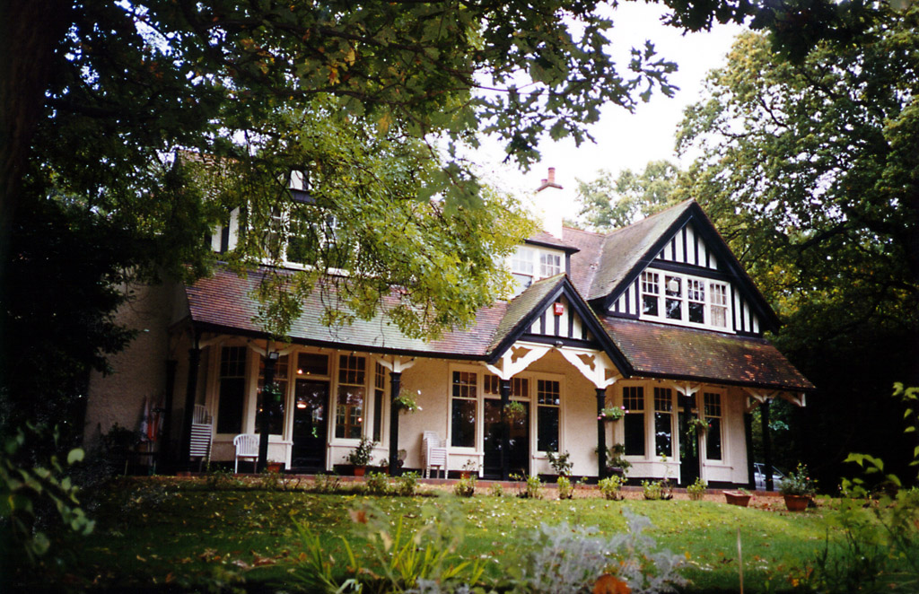
Foxgrove Club original golf clubhouse built circa 1912-22
A group of Beckenham residents formed the Foxgrove Golf Club and in March of the same year leased most of Beckenham Place Park, apart from the woods and the immediate surroundings of the home farm, for a period of 21 years. Little time was lost in building a club house and laying out the greens, for in October of the same year the first monthly medal meetings were held for both ladies and gentlemen. Shortly afterwards a commemorative dinner was held in the new clubhouse, which over fifty members attended. (source: Eric Inman)
1910 – Robert Borrowman publishes his ‘Beckenham Past and Present’ drawing on the works of Philipott, Hasted and Ireland as well as material he could access in Beckenham Parish records. He reiterates the origin of Beckenham Place to 1773 and Cator’s purchase of Beckenham Manor from Bolingbroke. It seems he is not aware of the prior sale of the old Manor House or of the problems Cator has gaining full occupation of Beckenham Manor until 1780. Nor of the fact that Beckenham Place is in the Manor of Foxgrove. Nevertheless, his book has interesting information about the Parish. Borrowman admits that information about the early history of Beckenham is ‘meagre’. Borrowman does reveal to us other historians of Kent such as Lambarde, Kilburne and Harris, but they throw no further light on my research.
1911 – The 1911 Census is now available and we can tell who was occupying the various buildings in the park. The Mansion was the aforementioned sanatorium which came under Beckenham district. The Stables, Garden Cottage and North gate Lodge, under Lewisham district, were occupied by golf course groundsmen and gardeners. It would appear that the Stables only had two families in residence whereas later as a public park the stables had 5 ‘Homesteads’ for park workers and families. In 1911 the Gamekeepers Cottage had a couple living there, we take this to mean the cottage that was in Summerhouse Wood. No mention of occupants of Home Farm in this census apparently.
1920 – Several conveyances of sites either on the private road, Beckenham Place Park or on Southend Road which were part of Cator’s parkland. One in 1921 on Foxgrove Road adjoining the private road, a house called Foxgrove which had been build in 1880’s?
1920 – Several conveyances of sites either on the private road, Beckenham Place Park or on Southend Road which were part of Cator’s parkland. One in 1921 on Foxgrove Road adjoining the private road, a house called Foxgrove which had been build in 1880’s?
1927
- The London County Council decides to acquire the park from the Cator
Estate. The minutes of the LCC record that there is a need for public
open space for the housing estates of Downham and Bellingham which are
being developed. A
transcript of the minutes can be found later on. Of course the LCC did not see the
Local Authority boundaries which bisected the park as overly important.
The price was £47,000 although the later conveyance states £43,000. At
some point the Mansion and Homesteads have living accommodation
provided for park staff. The Garden Cottage and the Gatehouse lodge
also are lived in by staff. Seven 'cottages' and maybe 2 apartments in
the Mansion. Over time managers, supervisors, gardeners and groundsmen
are accommodated there with their families. Maintenance and security
are provided by on-site staff. Large areas of woodland are fenced to
protect it with a balance of areas of protection with areas of free
access. The condition of the lake is not clearly known but the 1930's
map below shows the lake has been reduced in size. To the east of the
railway the land is described as a gravel pit, reed beds and an
athletics ground. Thomas Cook's had the athletics ground for a period
of time but it later became the Catford Sports and Social Club for
council employees. The gravel pit and reed beds are believed to have
been used for wartime bomb rubble or as one source describes for spoil
from the building of housing estates. Anyone having more information
please contact us. Old family photos or similar information welcome.
Apart from the reason that the LCC saw a need for open space, the
landed gentry had been finding it difficult to maintain estates after
WWI and maybe this was an incentive for the Cator Estate to dispose of
the park.
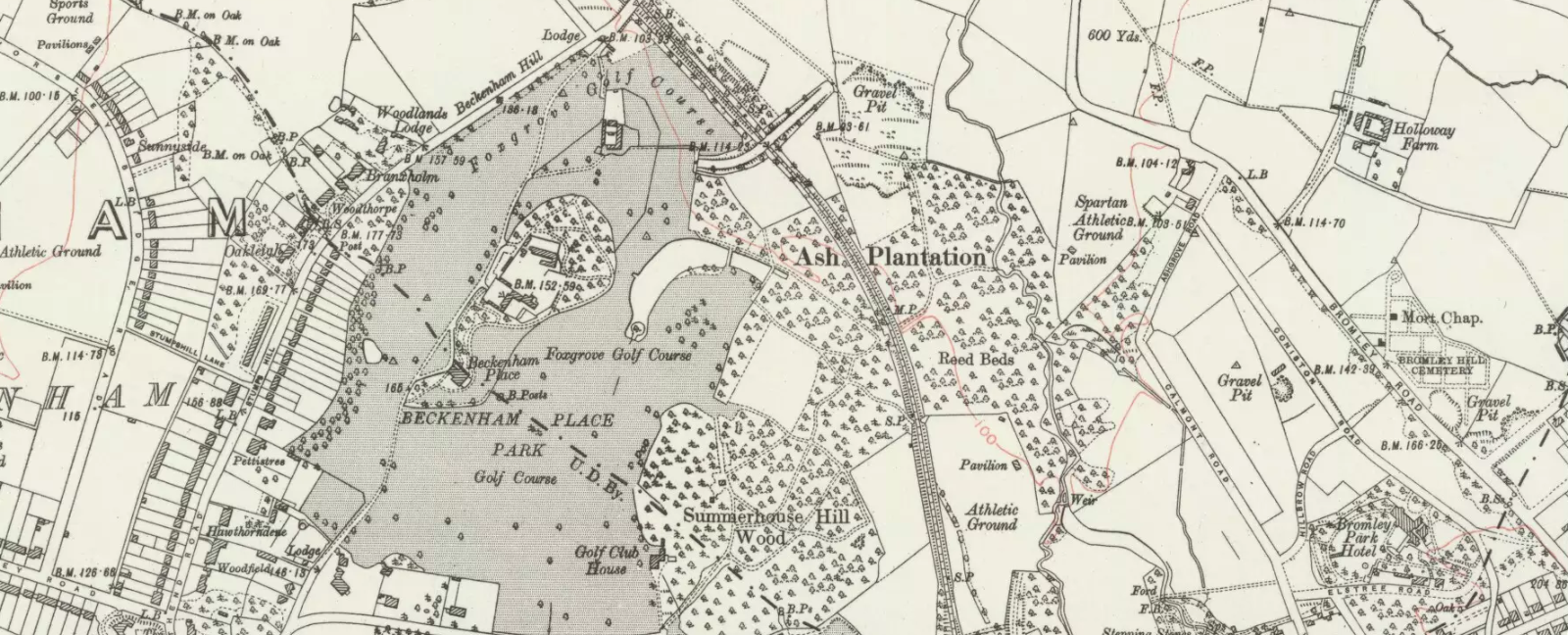
1928 – The date of the conveyance of Beckenham Place from the Cator Estate, John Cator(1862-1944) of Woodbastwick Hall, Norfolk, the vendor and the estate trustees to the purchaser, the London County Council dated 24th January. The LCC cites the Open Spaces Act 1906 as amended by the LCC General Powers Act 1926. The purchase price of £43,000 is made up of two parts, £16,000 under the Open Spaces Act and £27,000 under the General Purposes Act. It should be a matter of record that the southern part of the eastern side of the railway which we call Summerhouse Field must have been acquired at a later date as at one time this was Thomas Cooks Sports Ground and became the Catford (Lewisham) Council sports ground at a date to be discovered. It is described as an Athletics ground on the map accompanying the conveyance. Some areas of Beckenham Place parkland had been either partially sold or leased over a period of time from the late 19th Century to early 20th Century. Whereas it would once have extended to Foxgrove Road in the south and to Southend Road/Beckenham Hill Road in the west, properties were disposed of along the latter roads on the west and the private road ‘Beckenham Place Park’ was inserted into the landscape for large properties, only 1 of which survives, St. Margaret’s. The others have been redeveloped into smaller plots over time. For example a house called Dura Den is now a close of several smaller houses.
Stumpshill Wood is mostly outside of the park conveyance seemingly following the boundary between Beckenham Manor and Foxgrove Manor. Whether this has anything to do with the Cator’s ‘Lord of the Manor’ rights is subject to debate. The Land Act of the early 20th Century redefined some of these priveledges. It is still shown as an area of woodland on both sides of Beckenham Hill Road and Southend Road though some large houses are on the west side mostly in Lewisham Parish or Borough.
The farm, stables and lodges of the park had been leased and rented for several years prior to the LCC purchase. An area bordering Old Bromley Road on which now stands the ......Club, old abandoned changing rooms and the childrens playground is not included in the park purchase and must have been acquired at a later date or separately.
Some questions arise from the 1928 Conveyance map such as a building on Crab Hill on the site of later changing rooms for football pitches, a smaller hut close by. The path up from the Crab Hill entrance is more of an access into a gravel pit and it mush be assumed that the later Prisoner of War Camp had something to do with alterations in this area as well as any changes to do with public access to the park. The fate of the cottage or gamekeepers hut in the woodland which was even still showing on A-Z maps into the 1980’s is unclear but is now a few bricks at foundation level if you are lucky enough to find them.
The map explains the old water course to the lake in that there is a drain along Westgate Road following round into Beckenham Place Park (private road) and then turning into the park toward the lake. The lake had been reduced in size by approximately half by the time of the conveyance. Earlier maps show springs and ponds in this area and it is to be assumed that the spring is put into the drain in Westgate Road quite close to the school, which once had a pond on the site of its playground. The dryness of the stream or drain may be attributable to drying up of the spring or diversion of water into sewers. This can be compared to the drying up of Foxgrove Farm mote due to the West Kent Sewer installation and drying up of some ponds and drains on the west side of Stumpshill in the region of Braeside. Diversion of rain run-off from roofs and hard standing into drains rather than into the topsoil and groundwater can all contribute to drying up of the underlying clay and Blackheath (Harwich Formation) Beds. The fact that water for the new lake is drawn up from a borehole some depth below the surface indicates the dryness of the ground nearer the surface.
Home
Farm or Beckenham Place Park Farm depicted by a young girl who lived
there (Miss I. Krombach?)
1931
- The Home Farm is vacated and demolished. Above is one of two
paintings produced by a lady who lived at the farm when she was a young
girl. There are some references to fresh milk, new laid eggs and
chickens being supplied to the sanatorium in the 1920s from a home
farm, no trace of which now exists other than in some aerial views of
the park taken in 1996 the ‘footprint’ of the building can be seen
clearly in the grass as 'crop marks'. Maybe at least two farmhouses
were destroyed in the original creation of Beckenham Place Park and
perhaps a new one built to supply John Cator in his mansion. It could
be that Home Farm was in existence when Cator bought the land as the
Rocque map shows buildings between the site of the mansion and Flower
House. Some buildings shown on early maps appear to have been swept
away in the creation of the park. Home farm was just inside the north
gate. This was not demolished until 1931. Groundwork associated with
the 2018 landscape work may have covered over the evidence of the
farmstead, only time will tell.
If one studies the Roque map it might be deduced that there was a house already in this position and a farm in the vicinity of Home Farm. As map making was inaccurate before the Ordnance Survey then exact positions cannot be identified.
One
of the early farms was on the opposite side of the road to the mansion,
just outside the present southern gate to the park on a site now
occupied by modern houses. Rocque's 1745 map also shows a building and
gardens opposite the position of the present mansion, though whether
this was a farm, outbuildings or gardens belonging to the previous
house is not clear.It consisted of a picturesque huddle of buildings,
which had obviously grown up over the years and is well depicted in
this watercolour made in the early 1920s/30s by an unknown lady artist.
Reproduced by courtesy of Miss I Krombach, who spent some of her
childhood at the farm and is probably the artist.
The Home Farm lost much of its land when the private golf course was
constructed, originally consisting of 9 holes. The purchase of the park
by the LCC and the departure of the sanatorium to Chislehurst deprived
the farm of its reason for existence. Its final occupants from 1931‑33
were the Krombach family, in residence when the farm was leased by
United Dairies to stable its horses. It was demolished soon after they
left and the site incorporated into the now public golf course.(source
E.Inman) The position of Home Farm shown on a sketch map.
1933 - The Golf Course becomes public and at one time the busiest in
Europe, see 2016 for history and closure.
1935 – Oak tree avenue planted along the drive in the park to mark the Silver Jubilee of George V’s reign. (source; anecdotal evidence).
Among
the changes which are thought to have take place after the purchase of
the park from the Cator estate are: removal of some outbuildings and
greenhouses around the kitchen garden, conversion of the kitchen garden
into formal gardens and tennis courts, removal of the game keepers
cottage and pheasantry in the woodland. Conversion of the homesteads
including the installation of Crittal type windows and installation of
sheds for park management equipment. Essentially before English
Heritage property listing features which might otherwise have been
preserved were lost. But in the light of more recent decay due to
neglect then the situation is about the same.
1939/45 - WWII An Italian Prisioner of War 'Summerhouse' Camp was
constructed on Crab Hill and an anti aircraft gun and barrage balloon
emplacements are installed. Sheep grazing and growing of some crops for
the war effort is introduced. Curiously enough the nearer one comes to
the present day the more difficult it becomes to find out what happened
to the mansion and park but Eric Inman wrote most of the following... I
know of no bombs or rockets actually falling on the park, which is
quite surprising considering the numbers, which fell on the built-up
areas close by.
However, the recollections of Derek Bates who was aged 6 or 7 at the end of WWII and lived in the stable yard homesteads because his father was part of the park staff although he joined the RAF during the war. Derek recalls a V1 falling on the golf course in front of the mansion. In a memoir written primarily for his family but a copy donated to the Friends of Beckenham Place Park he recounts the windows and roof of their cottage being damaged and repaired, collecting bits of V1 and the army taking away parts of the rocket. Disappointedly he recalls his mother giving his shrapnel collection to the army. He also recalls seeing a V1 destroy housing nearby which must be the record below.
Nearby residents recall a bomb crater just off of Worsley Bridge Road and Greycot Road. The area experienced several bomb hits, V1's and V11's. Bomb strikes were mapped quite comprehensively.
This entry recalls a V1 strike near the park: “The Flying bomb exploded In Beckenham Hill Road. 1-11 ,2-16 Highland Croft,1-23 and 2-50 Braeside.184,186,188 Beckenham Hill Road, 37b Beckenham Hill Road, 31-37Southend Road, 42-80 Southend Road, Ada Lewis House Southend Road. Were damaged.”
An anti–aircraft gun and later a barrage balloon were sited near the mansion, with the operators of the latter being based in a wooden hut to one side of the mansion forecourt. (A recent park visitor, who had been stationed with the AA battery, informed us it was only here for a short time as the tactic was changed from having single weapons stationed locally, to having a larger battery at West Wickham). It has been said that Anti Aircraft fire injured or killed more civilians than it did enemy aircraft. Sheep were grazed on the golf course, but whether this displaced or supplemented the golf is something else it would be interesting to know.
Part
of the park was dug up to grow potatoes and other vegetables
particularly during the latter part of the war, when it was used as a
prisoner of war camp. It housed Italian prisoners and according to one
Italian book entitled ‘Prigionieri Italiani in Gran Bretagna (1940-47)
was Camp No 233, known as Summerhouse Camp, Ravensbourne, Bromley,
Kent. Probably some of the bumps in the ground may owe their origins to
this period and not to some more distant times as some believe. Some of
the paths through the woods also owe something to the efforts of the
prisoners, as well as stonework and path-laying in some local houses.
Another camp on Worsley Bridge Road accommodated German navy POW's
according to local residents.
A consultants report produced for the Heritage Lottery Fund bid found
that several high explosive bombs fell in the park but no damage to
buildings is recorded. Several websites show maps of bomb and rocket
explosion sites. No deaths were reported for those in the park.
An image on Google Earth Historic imagery shows the POW camp on Crab Hill
1945 – From here until 1990 very little is known apart from the fact
that the LCC/GLC managed the park and golf course and kept it
maintained to a high standard with staff and wardens. Derek Bates is
again a source of some information relating how his father spoke with
visitors to the gardens giving horticultural advice. Some photos from
his family album show how the park was well maintained.
I personally recall how busy the golf course was, with a long queue of cars waiting for the park to open with eager golfers. It was almost impossible to get a game at weekends and usually very busy during the week. For many years the golf course brought plenty of money into the coffers of Lewisham Council after 1970’s but very little money was spent on the infrasture of the park. Regretably few records are easy to acquire but at the Public Enquiry recent accounts ......
1971
- Control and ownership of the park passed from the Greater London
Council to the London Borough of Lewisham (LBL) and in 1995 the
boundaries were adjusted so that the whole of the park fell within
Lewisham. Prior to this the mansion was in Beckenham, (since 1965 part
of the new London Borough of Bromley), whilst the stables were in
Lewisham as evidenced by a number of parish boundary posts which can
still be seen within the park today. The condition of the
mansion and stables prior to Lottery funding reflects the inability of
any borough council to
fund, repair and maintain a Grade 11* nationally listed building
without additional support when
faced with competing higher priority responsibilities. Some sources
mention the park was briefly in the possession of Bromley Council but
we can’t find any evidence of that apart from the fact that prior to
the mid 1990's Bromley had some administrative powers over planning and
council tax or rates.
These
images are undated but pre 1990 when the homesteads were vacated and
post 1960 colour photography
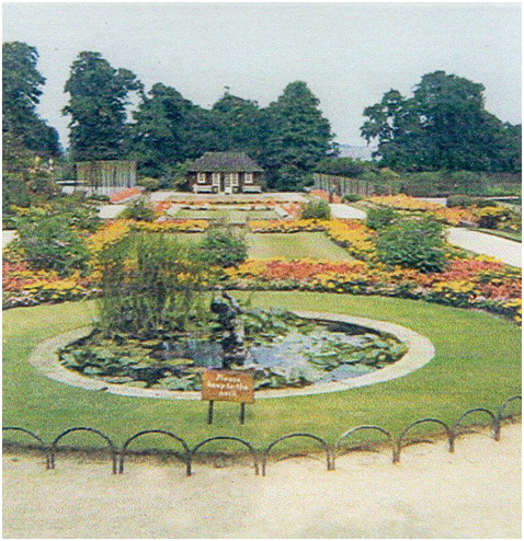 |
 |
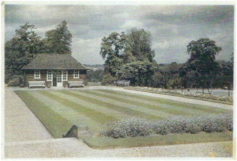 |
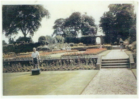 |
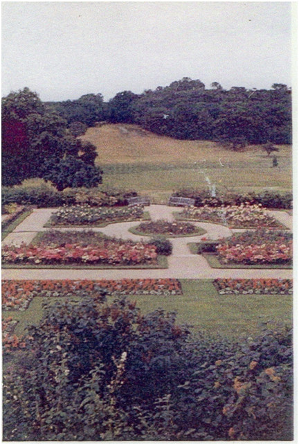 |
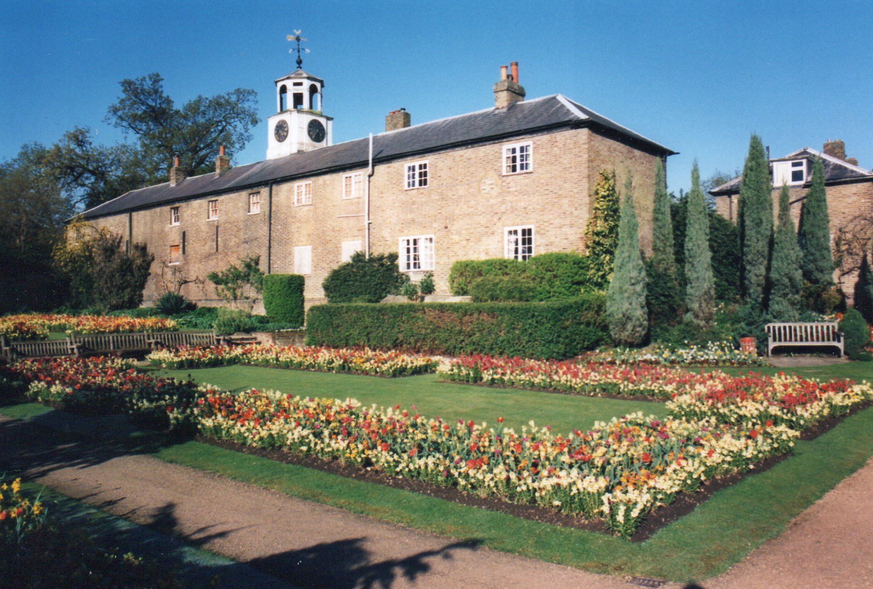 |
1976
- The Park and other open space is designated Metropolitan Open Land, a
form of inner city Green Belt under the Greater London Development Plan.
1984-7 – This extract from the Conservation Management Plan of 2009:
Records at English Heritage confirm the undertaking of further repair works in 1984-7 including the insertion of the large steel beams above the lantern, repairs to stacks, the aluminium light over the main hall, dry rot repairs. Investigation of the decorations to the ground floor ceilings was undertaken by English Heritage in about 1985. No record of the investigations has been found but they are understood to have been entirely consistent with the ceilings being of late C18 date.
1992 - Football pitches and changing rooms in the eastern part of the park are closed to enable David Lloyd scheme (DLL). Stable Block Homesteads and other accommodation cleared of tenants to provide vacant possession to DLL. 11 football pitches were fully used at weekends so this was another example of removing one group of park users for another as with the golfers at a later date.
1992 – London Borough of Lewisham attempt to pass occupation of the park to David Lloyd Leisure for the purposes of an indoor Tennis centre and extended golf facilities. A Public Enquiry leads to rejection of the plans to extend golf and add indoor tennis centre. Ironically, this scheme would have more than doubled the golf area, as well as covering a large area of the park with indoor sports facilities. Later, in 2015, the golf is deemed unviable and removed completely.
1993/2000 – Although the Tennis Centre scheme is refused the Park is managed by David LLoyd Leisure as a 7 year management contract had been awarded prior to the public enquiry. Rejection of the tennis centre and golf extension plans was largely because of the MOL status of the park. In 1993 planning permission was granted in principle by London Borough of Lewisham for a sporting venture, which would have radically transformed what is Metropolitan Open Land (MOL) into inaccessible sporting areas, at the expense of informal leisure activities by the general public. Determined opposition by a widely supported and well-organised ‘Save Beckenham Place Park Campaign’ and other groups led to a public inquiry and rejection of the application in 1994. Many local and national groups were active in the campaign, primarily the Ravensbourne Valley Preservation Society, a local residents association. Other groups included The London Wildlife Trust, Council for the Protection of Rural England, Friends of the Earth and Save BPP Campaign group. Despite DLL being a large tennis related company they cannot provide enough nets for 3 tennis courts?
1993 - The Friends of Beckenham Place Park is inaugurated to attempt to positively influence the management of the park for conservation, heritage and open space use. At the same time the London Borough of Lewisham ex-Mayor John Rudd establishes the Beckenham Place Park Working Party for all interested parties to have a forum to discuss park related matters. Unfortunately the Council disband this forum in 2016 in a democratic backward step, in favour of forums which divide opinion.
1996 – The Friends of Beckenham Place Park open a volunteer run visitor centre in a vacant cottage in the stable block. There had already been a high level of vandalism and the Friends repaired and decorated the cottage to a degree where a park conservation worker lived there for some years afterwards. Permission was granted to open a Visitor Centre in the stable block in January 1996 to be run by volunteers from the Friends.
1997 – about this time, Eric Inman produces a series of articles on the History of Beckenham Place for the Friends of BPP newsletter. Eric and I accepted various other sources such as Hasted as bonafide but this account explores aspects of the History which have shown Hasted and others to be inaccurate.
1999 – The Visitor Centre removed to the Mansion in November 1999. We regret leaving it as it might have saved the stable block from the later fire in 2011.
The
21st Century
2000 - The Friends’ Visitor Centre moves into the Mansion at the invitation of a park manager.
2000/2014
- various changes is park management, consultations regarding use of
buildings, including rejection of a charitable trust bid for management
of the mansion. As part of one management tendering exercise around
2009 a firm of architects, Rees Bolter, produced a Conservation
Management Plan
(CMP) for the Mansion and a summary of possible uses. The CMP has a lot
of interesting information about the park and mansion including details
of past stages of renovation and repair. It is worth a read but bear in
mind that some of the history has since been altered and revealed. The
CMP describes how the mansion resembles Palladian designs in Italy
among other things.
2002 - Local Nature Reserve Listing (LNR) and Large Turkey Oak blown
down: Wayne Butler as an in-park conservation officer employed by a
park management company gets the park listed as a nature reserve. The
Turkey Oak tree which was the second largest of its species in the UK
and was over 230 years old came down on a windy day. The trunk had been
hollow for many years and it had suffered from vandalism which weakened
it. The date and age indicates it may have been planted by Cator.
Perhaps supplied by his father in law, Peter Collinson who supplied
many of his contacts with young trees probably cultivated in his Mill
Hill garden. Turkey Oak was introduced from Turkey early in the 18th
century and thought to be a valuable timber but it decays quickly when
harvested. 15 years after its demise very little can be seen of it
apart from some largest pieces of its trunk. It would have stood very
near the end of the original lake.
Turkey Oak - over 230 years old
2004 (?) - Mander and Mitchenson Theatre Collection leaves the mansion: having occupied most of the mansion upper floors for over 20 years the collection is moved firstly to the Greenwich University and then to Bristol University to join other theatre memorabilia. Though the collection originally had plans to turn the mansion into a theatre museum they both did not raise enough funding and also did not in my opinion take the opportunity to apply to the National Lottery Arts Fund to achieve their aims. Though occupying the mansion the collection made no contribution to its upkeep and was not open to the public.
2009 – A Conservation Management Plan is produced by Rees Bolter Architects. One of several ‘consultations’ commissioned by L.B.Lewisham this plan outlines possible uses for the mansion, its condition and history of maintenance. Though containing some errors or omissions regarding the history in our view, the Plan was comprehensive but not acted upon to any great degree. The Plan may be viewed through a link on the Friends of BPP website.
The management plan was introduced thus: (but in this history we dispute some dates) but the plan does reveal some otherwise unknowns.
Beckenham Place is a Grade II* listed mansion of c1774 with a simple stone faced exterior and a number of important interior rooms. It was extended in about 1810 by the construction of a new entrance front which incorporates a great deal of material from the great house of c1723 at Wricklemarsh. The estate was purchased by John Cator in 1773 and remained in the Cator family until 1926 when it was purchased by the London County Council. The Cators occupied the house until about 1825; it was let to a series of tenants during the remainder of the nineteenth century and was in institutional use in the early twentieth century. Since passing into public ownership the house has provided accommodation for refreshment rooms and golf related uses on upper and lower ground floor levels. Upper floors were in residential use for a time, were briefly occupied by a theatre archive and have now been empty for about ten years. The mansion is an important building, reflected in its Grade II* listing, principally because of its position in the designed landscape, the interiors of the upper ground floor and the salvaged fragments of Wricklemarsh.
As the conservation management plan concentrated on the house more will be said in ‘Additional Information’ under ‘The House on Stumps Hill’
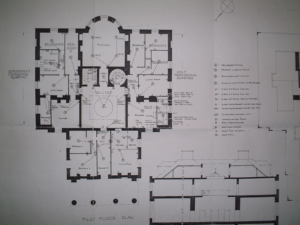
Floor
Plan of the Mansion
A gap in the history here needs filling with information regarding Consultations and Tendering for use of the Mansion, such as the bid by a Korean Hotelier which would have involved unacceptable extension of the building.
The
Golf Course is put under the management of Glendale with the intention
of increasing income from the course. However, Lewisham retain all the
cost centre expenses such as grounds staff and machinery therefore most
income remains with Glendale and all costs incur to L.B.Lewisham
2011 - Most of the Stable Block destroyed by fire after being left
abandoned and insecure for several years. Most of the heritage features
of the building are destroyed including the clock which was about 300
years old. Below, the rear of the stable block facing the gardens in
less than perfect but complete condition. The righthand end had been
extensively remodelled probably after LCC takeover but the centre and
left hand end had old if not original features. The clock was nearly
300 years old and may have once been at Clockhouse, Penge.
2014 - London Borough of Lewisham decide to bid for Heritage Lottery Fund money under the 'Parks for People' scheme to fund improvements to the park. The mansion remains excluded from any funding at this time. Although various works had been done to the mansion over a long period such as repairing the roof, installing disabled toilets etc. No complete restoration has been done. If we added up all the money spent on tinkering it would probably have paid for a proper job or at least provided match funding for a grant a long time ago. However, the scheme is not popular with all and various people object, not least the golfers whose course is deemed to close under the scheme. The Public Consultation such as it was presented four schemes either including the existing golf course or closing the golf course in favour of an 'Eighteenth Century Parkland Landscape' restoration. The latter narrowly won having the biggest quarter of the votes out of about 300 public responses. The restoration should include the reconstruction of a lake, rebuilding of the stable block and restoration of other Homestead buildings.
2014 - The Environment Agency are evaluating a flood alleviation scheme to use part of the park to prevent flooding further downriver. Floods have been recorded in Lewisham, Southend, and Beckenham over hundreds of years but infrequently i.e. the 100 year flood which intimates a flood event will happen even if rarely. A prevention scheme was installed on the River Quaggy at Sutcliffe Park some years ago. the Quaggy / Ravensbourne and Pool rivers have combined by the time they get to Lewisham near the station. A deluge backs up at that point threatening housing and businesses. The result of uncontrolled or ill advised development on river floodplains. There could be some landscaping and nature habitat advantages to this scheme but at time of writing detailed plans and consultation is awaited.
2015 - The mansion remains at risk awaiting HLF restoration bid, The park and homesteads await the production of stage 2 HLF bid for restoration etc.
2016 - Lewisham Council close the public golf course, unable or unwilling to make it financially viable. The Mansion is put on short term lease to a property management organisation RJK Properties with intentions to increase use of the building.
At this time Lewisham Council (councillors and officers one presumes) decide to disband the Beckenham Place Park Working Party, probably because members of the working party tell them things they don’t like to hear. They establish 3 forums which in the view of some is a ‘divide and rule’ tactic. Public representation of views is suppressed by this procedure in my opinion.
2017 - Heritage Lottery Fund bid for £4.9million approved for park and some buildings regeneration. At time of writing the Local Authority are tendering for design consultants for the actual scheme after former consultants produced plans for the bid? Why the original tender couldn't have included a proviso that if the bid was approved the former consultants would continue with the scheme God alone knows. Seems a lot of the money will be spent before a shovel hits the ground or a brick is laid. Fairly comprehensive plans were submitted with the bid and for the planning permission application but a furter 'detailed design' phase is being tendered.
2017
- May 13th The Public Park's 90th anniversary. This is the date of the
LCC meeting in 1927 which appears to have decided the purchase of the
Park from The Cator estate. The Foxgrove Club Golf Course and the
Norwood Sanatorium had active leases for a short time.
2017 - August: New design consultants have been appointed to perform
the detailed planning. Planning permission for the scheme is still not
granted awaiting, we assume, presentation of detailed plans. Apparently
some concerns remain regarding the lake and its proposed source of
water i.e. the stream appears inadequate, a borehole would be perhaps
inadmissable and its event suggested that filling of the lake would be
by mains water.
2017 - October. The planning application for grant related works is
approved by Lewisham Council. Alterations to the landscaping will
include removal of some trees which were planted to define the now
closed golf course. The Mansion although in use and under a short term
lease to RJK Properties is still on the English Heritage at risk
register and not included in any current restoration grant or scheme.
2018 – Over the winter of 2017/2018 a large number of trees have been felled to meet the ‘vision’ of the landscape architects and invisible ‘design team’. The desire to recreate a lake and wetland area required the felling of what were quite mature trees of up to 100 years age. Due to the lack of maintenance of the former artificial lake it was either overgrown, partially filled in and generally left to its own devices. As the new lake may have to be filled with an engineered water supply I wonder what the long term future of any new lake will be. As previously mentioned it seemed the original lake was created for John Cator circa 1790, probably extended or remodelled by his nephew John Barwell Cator after inheriting the estate circa 1810. Subsequently reduced in size and mostly dried up due to diversion or building over the supplying stream. Any overflow of the lake area is taken by a conduit under the railway to the Ravensbourne. At time of writing (Spring 2018) I’m informed that the current rainfall is creating a pond. The area will require artificial lining as most man-made lakes either made use of natural clay beds or clay was imported and ‘puddled’ down as a liner.
Some work is commencing around the Stable Block but we have no indication as to whether original 18th century heritage features will be conserved or restored. “Heritage Lottery” seems just that.....a lottery as to whether any heritage is preserved.
An update on the progress of the works reveals that contamination of soil at the site of the lake requires sealing in of contaminant and cancellation of a proposed raised landscaping feature. Some architectural feature flooring in the stable block is to be retained. Some archaeology is discovered under the old lake bed. The new lake is to be provided with water from a borehole as the old water source is either dried up or periodically may carry polluted road run-off.
Excavations for the lake and car park are creating large piles of spoil and the installation of pathways is also contributing to this eyesore. The concept of ‘restoring 18th century landscape’ is in fact obscuring the landscape as well as destroying it. All I can say is that previous landscaping for golf course or sports pitches did not endeavour to conserve any landscape either.
2019 – Work continues on the landscape of the park, installing a new lake and rearranging the garden area, installing a car park and continued work on the stable block, homesteads and garden cottage.
Contaminated war time landfill was discovered on the lake site and was tipped on another area of the park under protective plastic sheeting.
The Flood Alleviation scheme for the east side of the park was abandoned in late 2018 due to escalating costs, perhaps among other reasons. Now the fate or prospect of funding for works to that side of the park is in doubt.
Although there is some support for the works, there have been objections and criticism of some of the works as not being in keeping with ‘restoration of 18th century landscape’ in fact destroy and covering up a lot of it. Excessive tree planting which alters the character of some areas and felling of mature or maturing trees purely for visual aesthetic reasons. One ancient tree was drawn to the attention of project workers as being in need of management and lopping to balance the crown. The work was refused and subsequently the tree fell and though the work might not have prevented it we will never know if conservation could have been achieved.
2019
– July, The lake and Homesteads are opened but shortly after some
safety concerns are raised concerning use of the lake, some children
rescued from deep water. The profile of the lake bed is such that it
deepens from paddling depth to over 2 metres quite suddenly. Maybe a
forseeable design flaw as a gradually sloping lake bed would not hide
any surprise drops. The other unforeseen issues around the lake have
required temporary fencing, security patrols and additional safety
measures
The Homestead cafe is opened to the delight of some. Unfortunately the stable yard looks like its just been resurfaced over the top of any other surfaces which might have had some historic or heritage significance. The new clock tower (minus the destroyed ancient clock) cannot take the weight of the bell which is apparently dated to 1734 (probably the date which it was installed at Clockhouse). The bell is destined to be hung inside the cafe area (time gentlemen please).
Works are still being carried out and snagging to address footpath erosion, stairways etc
The 'mound' near the railway who's main purpose is to accommodate spoil from lake excavation and provide a viewpoint etc is merely a pile of earth with steps and a path leading to it and shows signs of being a mud trap. The old burning yard which we know has a concrete surface somewhere underneath it has been levelled but the remains of years of waste disposal can be seen in the soil, such as plastics and glass. Several young trees planted to reclaim the site a few years ago have been bulldozed in the process. One step forward, two back it seems.
As the flood scheme has been cancelled L.B .Lewisham are planning a 'makeover' of the east side of the park with reed beds and more mounds of spoil. I'm informed this is to meet the Heritage Lottery Grant conditions which included a guarantee that 'improvements' would be made to the east side. L.B.Lewisham are providing a further £2m for the scheme.
The Friends of Beckenham Place Park Visitor Centre in the mansion on Sundays was closed as a viable space was not made available and their volunteers maintain the Sensory Wildlife Garden area of the formal gardens. Volunteers under the L.B.Lewisham volunteer coordinator perform works in other areas of the garden and around the park. The Garden Cottage is a volunteer hub and base for the coordinator.
2020 - The Covid outbreak coincided with the closure of the Visitor Centre and and curtailed any intention by the the Council and it partners to provide outreach, education and interpretation. The park became popular as one of the few places people could access during lockdown restrictions. The Friends of BPP could not continue maintaining the Sensory garden during lockdown but resumed when restrictions were lifted.
2021 - A Friends volunteer organised a funding application to restore the ancient pond which was dredged and a plantform installed for activities like pond dipping or casual enjoyment of the area. A garden wall collapsed and repairs were planned. The walls are Grade II listed by English Heritage in the same way as the buildings. Friends volunteers resume working in the garden.
2022 - Garden wall repaired. The Friends organised some events such as Fungi Walk, History walk, Bluebell walk and continue to maintain the Sensory Garden.
2023
- The lack of sufficient numbers of volunteers to take on roles in the
Friends forces it to wind up activities. The funds available to the
Friends in the form of unspent grants for the Ancient Pond and Sensory
Garden are transferred to London Borough of Lewisham for future
expenditure on those areas. A balance of funds amounting to over
£5k is transferred for distribution in grants to London Borough
of Lewisham open spaces volunteer groups via the Biodiversity
Partnership grant scheme.
A Crystal Ball is required beyond this point.
See Additional Information in another next file to be completed soon. Full references will be added here shortly and amendments or corrections will continue to be made to this account.
About the Park Buildings History Nature Trail Sensory Garden Gardens Woodland Meadows Riverside Wildlife Golf Course
This page gives a brief timeline of the main
events in the evolution of Beckenham Place Park Timeline of the park's evolution:
|